
Nebraska topographic map
Interactive map
Click on the map to display elevation.
About this map
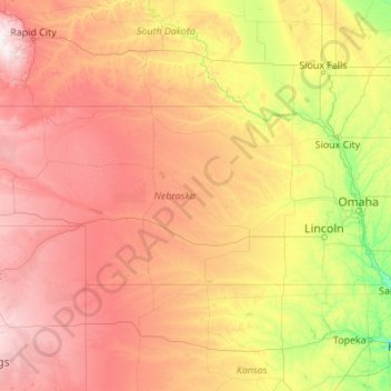
Name: Nebraska topographic map, elevation, terrain.
Location: Nebraska, United States (39.99998 -104.05352 43.00127 -95.30805)
Average elevation: 2,451 ft
Minimum elevation: 837 ft
Maximum elevation: 7,083 ft
Nebraska is composed of two major land regions: the Dissected Till Plains and the Great Plains. The easternmost portion of the state was scoured by Ice Age glaciers; the Dissected Till Plains were left after the glaciers retreated. The Dissected Till Plains is a region of gently rolling hills; Omaha and Lincoln are in this region. The Great Plains occupy most of western Nebraska, with the region consisting of several smaller, diverse land regions, including the Sandhills, the Pine Ridge, the Rainwater Basin, the High Plains and the Wildcat Hills. Panorama Point, at 5,424 feet (1,653 m), is Nebraska's highest point; though despite its name and elevation, it is a relatively low rise near the Colorado and Wyoming borders. A past tourism slogan for the state of Nebraska was "Where the West Begins" (it has since been changed to "Honestly, it's not for everyone"). Locations given for the beginning of the "West" in Nebraska include the Missouri River, the intersection of 13th and O Streets in Lincoln (where it is marked by a red brick star), the 100th meridian, and Chimney Rock.
Other topographic maps
Click on a map to view its topography, its elevation and its terrain.
Kingwood
United States > Texas > Harris County > Houston
Kingwood, Houston, Harris County, Texas, 77345, United States
Average elevation: 72 ft
Houston
United States > Texas > Harris County
Houston, Harris County, Texas, United States
Average elevation: 82 ft
Conroe
United States > Texas > Montgomery County
Conroe, Montgomery County, Texas, United States
Average elevation: 203 ft
Pittsburgh
United States > Pennsylvania > Allegheny County
Pittsburgh, Allegheny County, Pennsylvania, United States
Average elevation: 994 ft
San Francisco
San Francisco, California, United States
Average elevation: 207 ft
Seattle
United States > Washington > King County
Seattle, King County, Washington, United States
Average elevation: 131 ft
San Diego
United States > California > San Diego County
San Diego, San Diego County, California, United States
Average elevation: 410 ft
San Fernando Valley
United States > California > Los Angeles County > Los Angeles
San Fernando Valley, Los Angeles, Los Angeles County, California, 91406, United States
Average elevation: 1,627 ft
Dallas
United States > Texas > Dallas County
Dallas, Dallas County, Texas, United States
Average elevation: 525 ft
Boston
United States > Massachusetts > Suffolk County
Boston, Suffolk County, Massachusetts, United States
Average elevation: 82 ft
Montgomery County
Montgomery County, Texas, United States
Average elevation: 226 ft
Katy
United States > Texas > Fort Bend County
Katy, Fort Bend County, Texas, United States
Average elevation: 144 ft
Cypress
United States > Texas > Harris County
Cypress, Harris County, Texas, 77433, United States
Average elevation: 151 ft
Austin
United States > Texas > Travis County
Austin, Travis County, Texas, United States
Average elevation: 709 ft
Manhattan
United States > New York > New York County > New York
Manhattan, New York County, New York, United States
Average elevation: 52 ft
Denver
United States > Colorado > Denver County > Denver
Denver, Denver County, Colorado, United States
Average elevation: 5,525 ft
Salt Lake City
United States > Utah > Salt Lake County
Salt Lake City, Salt Lake County, Utah, United States
Average elevation: 5,223 ft
Wake Forest
United States > North Carolina > Wake County
Wake Forest, Wake County, North Carolina, United States
Average elevation: 344 ft
Philadelphia
United States > Pennsylvania > Philadelphia County
Philadelphia, Pennsylvania, United States
Average elevation: 144 ft
Chicago
United States > Illinois > Cook County
Chicago, Cook County, Illinois, United States
Average elevation: 597 ft
Export
United States > Pennsylvania > Westmoreland County > Export
Export, Westmoreland County, Pennsylvania, 15632, United States
Average elevation: 1,122 ft
Whidbey Island
United States > Washington > Island County
Whidbey Island, Island County, Washington, United States
Average elevation: 148 ft
San Jose
United States > California > Santa Clara County
San Jose, Santa Clara County, California, United States
Average elevation: 866 ft
Miami
United States > Florida > Miami-Dade County
Miami, Miami-Dade County, Florida, United States
Average elevation: 16 ft
Milwaukee
United States > Wisconsin > Milwaukee County
Milwaukee, Milwaukee County, Wisconsin, United States
Average elevation: 673 ft
Greenville
United States > South Carolina > Greenville County
Greenville, Greenville County, South Carolina, United States
Average elevation: 951 ft
Las Vegas
United States > Nevada > Clark County
Las Vegas, Clark County, Nevada, United States
Average elevation: 2,480 ft
Jefferson County
Jefferson County, Colorado, United States
Average elevation: 7,838 ft
Lake Tahoe
United States > California > Placer County
Lake Tahoe, Placer County, California, United States
Average elevation: 6,814 ft
Portland
United States > Oregon > Multnomah County
Portland, Multnomah County, Oregon, United States
Average elevation: 253 ft
Albuquerque
United States > New Mexico > Bernalillo County
Albuquerque, Bernalillo County, New Mexico, United States
Average elevation: 5,538 ft
Saint Petersburg
United States > Florida > Pinellas County
Saint Petersburg, Pinellas County, Florida, United States
Average elevation: 13 ft
San Antonio
United States > Texas > Bexar County
San Antonio, Bexar County, Texas, United States
Average elevation: 810 ft
Charlotte
United States > North Carolina > Mecklenburg County
Charlotte, Mecklenburg County, North Carolina, United States
Average elevation: 679 ft
Reno
United States > Nevada > Washoe County
Reno, Washoe County, Nevada, United States
Average elevation: 5,413 ft