
巍山彝族回族自治县 topographic map
Interactive map
Click on the map to display elevation.
About this map
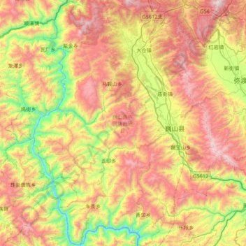
Name: 巍山彝族回族自治县 topographic map, elevation, terrain.
Location: 巍山彝族回族自治县, 大理白族自治州, 云南省, 中国 (24.94376 99.92555 25.53966 100.42365)
Average elevation: 6,578 ft
Minimum elevation: 3,796 ft
Maximum elevation: 10,161 ft
巍山境内山脉属于横断山脉云岭南部的延伸部分,东部是哀牢山北段,中部属于无量山北段地区,两山之间为巍山坝区,坝区面积167.66平方公里。地势由西北向东南倾斜。境内河谷、盆地、山地相间分布。最高点海拔3,037米,最低点海拔1,050米,县城海拔1,725米。
Other topographic maps
Click on a map to view its topography, its elevation and its terrain.
西双版纳热带植物园-百竹园
西双版纳热带植物园-百竹园, 勐仑镇, 勐腊县, 西双版纳傣族自治州, 云南省, 666100, 中国
Average elevation: 1,834 ft