Pazardzhik topographic map
Click on the map to display elevation.
Pazardzhik
The northern parts of the region include the middle ridges of the Sredna Gora mountain, to the south the relief flattens and forms the westernmost parts of the Upper Thracian Plain and to the south are located the Rhodope Mountains where most of the forests are situated. The highest point of the region is Savov Vrah at an altitude of 2,306 m while the lowest altitude is around 200 m in the plains of the central area. The climate is transcontinental with milder winter than northern Bulgaria in the lowlands but with very low temperatures and high snowfall in the mountain areas. The average annual temperature is 11.3 °C.
About this map
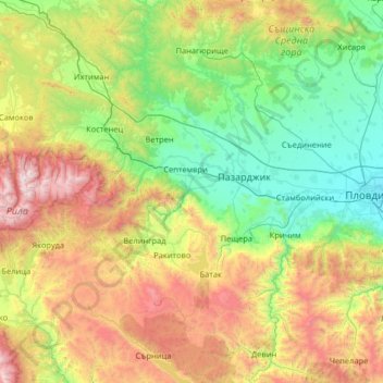
Name: Pazardzhik topographic map, elevation, terrain.
Location: Pazardzhik, Bulgaria (41.66851 23.75533 42.62901 24.53780)
Average elevation: 3,054 ft
Minimum elevation: 509 ft
Maximum elevation: 9,511 ft
Other topographic maps
Click on a map to view its topography, its elevation and its terrain.

Rhodope Mountains
In geomorphological terms, the Rhodopes are part of the Rila-Rhodope massif, which is the oldest landmass on the Balkan peninsula. The Rhodopes are spread over 14,735 square kilometers (5,689 sq mi), of which 12,233 square kilometers (4,723 sq mi) are on Bulgarian territory. They have the greatest extent of…
Average elevation: 1,644 ft


Bansko
Bansko (Bulgarian: Банско [ˈbansko]) is a town in southwestern Bulgaria, located at the foot of the Pirin Mountains at an elevation of 1200m above sea level. It is a ski resort.
Average elevation: 3,392 ft




Sredna Gora
Bulgaria > Sofia > Koprivshtitsa
The mountain is divided into three parts by the rivers Topolnitsa and Stryama — Ihtimanska Sredna Gora to the west, Sashtinska Sredna Gora in the center, and Sarnena Sredna Gora to the east. Compared to most other mountain ranges in Bulgaria, Sredna Gora has lower average altitude, which determines higher…
Average elevation: 4,265 ft




Vihren
Vihren (Bulgarian: Вихрен [ˈvixrɛn]) is the highest peak of Bulgaria's Pirin Mountains. Reaching 2,914 metres (9,560 ft), it is Bulgaria's second and the Balkans' third highest, after Musala and Mount Olympus. Although Vihren is deprived of lakes and streams due to the karst topography, a number of…
Average elevation: 8,012 ft


Borovets
Borovets (Bulgarian: Боровец [ˈbɔrovɛt͡s]), known as Chamkoria (Чамкория [ˈt͡ʃam koˈrijɐ]) until the middle of the 20th century, is a popular Bulgarian mountain resort situated in Sofia Province, on the northern slopes of Rila mountain, at an elevation of 1350 m.
Average elevation: 4,573 ft
Rila mountain range
Rila (Bulgarian: Рила, pronounced [ˈriɫɐ]) is the highest mountain range of Bulgaria, the Balkan Peninsula, and Southeast Europe. It is situated in southwestern Bulgaria and forms part of the Rila–Rhodope Massif. The highest summit is Musala at an elevation of 2,925 m which makes Rila the sixth…
Average elevation: 8,284 ft



Gorno Kraishte
The terrain is mountainous and hilly, covering parts of Western Rila and Rhodope Mountains and the valley in the upper reaches of the Mesta River. The average altitude is 850 meters. The climate is transitional continental with an average annual temperature is 8 °C. Winters are cold, with an average January…
Average elevation: 2,841 ft



Elhovo
Central to this region is the field of Elhovo. Its flat surface extends on both sides of the river Tundzha which is flowing from the north. The average elevation is 100–150 m. In the peripheral parts the field gradually passes into the gentle slopes of the Manastira and the Dervent Heights.
Average elevation: 397 ft
Sandanski
Sandanski has developed in an amphitheatrical fashion on the outer south-west flanks of Pirin Mountains along the lower reaches of Sandanska Bistritsa River. The town's altitude varies between 240 and 300 meters. Its geographical location between Kresna and Rupel Gorges determines town's mild winter…
Average elevation: 906 ft

Vihren
Vihren (Bulgarian: Вихрен [ˈvixrɛn]) is the highest peak of Bulgaria's Pirin Mountains. Reaching 2,914 metres (9,560 ft), it is Bulgaria's second and the Balkans' third highest, after Musala and Mount Olympus. Although Vihren is deprived of lakes and streams due to the karst topography, a number of…
Average elevation: 8,012 ft

Belmeken
Belmeken (Bulgarian: Белмекен) is a summit in the northeastern part of the Rila Mountain in southwestern Bulgaria with a height of 2,626 m. It is built up of granite. Its northern slopes are steep and rise over the Kutlinite cirque. The southern and southeastern slopes are oblique. To the southeast at…
Average elevation: 7,546 ft


Vitosha
Due to a great variability in elevation, a rich diversity of climates, flora and fauna can be found within the park. Research has revealed that on the comparatively small area of the mountain there are 1,500 species of higher plants, 500 species of fungi, 500 species of algae, 326 species of mosses, and 200…
Average elevation: 6,906 ft

Dospat
The town was probably founded by Despot Alexius Slav in the 12th or 13th century, from whose title (despot) its name is very likely derived. Dospat Dam is the highest dam in Bulgaria by altitude and, with its 22 km2 of water area, the second largest in capacity. It is fed by the River Dospat.
Average elevation: 4,278 ft


Dospat
The town was probably founded by Despot Alexius Slav in the 12th or 13th century, from whose title (despot) its name is very likely derived. Dospat Dam is the highest dam in Bulgaria by altitude and, with its 22 km2 of water area, the second largest in capacity. It is fed by the River Dospat. At the bottom of…
Average elevation: 4,278 ft

Bansko
Bansko lies at the foot of the Pirin Mountains, not far from the national park of the same name, in the valley of the Nestos River at an elevation of 925 meters above sea level. It is a ski resort. The city is about 160 km from Sofia and about 220 km from Thessaloniki.
Average elevation: 3,392 ft

Pernik
Pernik is the second largest town in western Bulgaria. The town is located in the Pernik Valley. part of the ethnographic region of Graovo, at an altitude between 700 and 850 metres (2,297 and 2,789 feet), length of 22 kilometres (14 miles) and is surrounded by mountains Vitosha, Lyulin and Golo Bardo. Through…
Average elevation: 2,694 ft