
美濃加茂市 topographic map
Interactive map
Click on the map to display elevation.
About this map
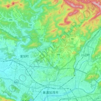
Name: 美濃加茂市 topographic map, elevation, terrain.
Location: 美濃加茂市, Prefectura de Gifu, Japón (35.42990 136.95900 35.55371 137.08681)
Average elevation: 492 ft
Minimum elevation: 131 ft
Maximum elevation: 1,785 ft
Other topographic maps
Click on a map to view its topography, its elevation and its terrain.
生野区
Japón > Prefectura de Osaka > Osaka
生野区, Osaka, Prefectura de Osaka, Japón
Average elevation: 26 ft