
Ota topographic map
Interactive map
Click on the map to display elevation.
About this map
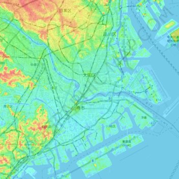
Name: Ota topographic map, elevation, terrain.
Location: Ota, Tokio, Japón (35.48166 139.65283 35.61309 139.85782)
Average elevation: 33 ft
Minimum elevation: -33 ft
Maximum elevation: 167 ft
Other topographic maps
Click on a map to view its topography, its elevation and its terrain.
生野区
Japón > Prefectura de Osaka > Osaka
生野区, Osaka, Prefectura de Osaka, Japón
Average elevation: 26 ft