
伊賀市 topographic map
Interactive map
Click on the map to display elevation.
About this map
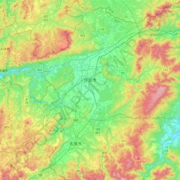
Name: 伊賀市 topographic map, elevation, terrain.
Location: 伊賀市, Prefectura de Mie, Japón (34.55755 136.01995 34.90202 136.34234)
Average elevation: 1,142 ft
Minimum elevation: 135 ft
Maximum elevation: 3,031 ft
Other topographic maps
Click on a map to view its topography, its elevation and its terrain.
生野区
Japón > Prefectura de Osaka > Osaka
生野区, Osaka, Prefectura de Osaka, Japón
Average elevation: 26 ft