
Ise topographic map
Interactive map
Click on the map to display elevation.
About this map
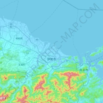
Name: Ise topographic map, elevation, terrain.
Location: Ise, Prefectura de Mie, 516-0037, Japón (34.38472 136.63261 34.65348 136.82099)
Average elevation: 171 ft
Minimum elevation: -16 ft
Maximum elevation: 1,932 ft
Other topographic maps
Click on a map to view its topography, its elevation and its terrain.
生野区
Japón > Prefectura de Osaka > Osaka
生野区, Osaka, Prefectura de Osaka, Japón
Average elevation: 26 ft