
弥渡县 topographic map
Interactive map
Click on the map to display elevation.
About this map
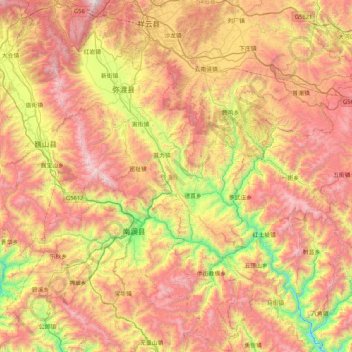
Name: 弥渡县 topographic map, elevation, terrain.
Location: 弥渡县, 大理白族自治州, 云南省, 中国 (24.78347 100.31986 25.53581 100.77907)
Average elevation: 6,713 ft
Minimum elevation: 3,488 ft
Maximum elevation: 10,151 ft
Other topographic maps
Click on a map to view its topography, its elevation and its terrain.
西双版纳热带植物园-百竹园
西双版纳热带植物园-百竹园, 勐仑镇, 勐腊县, 西双版纳傣族自治州, 云南省, 666100, 中国
Average elevation: 1,834 ft