
The Backbone topographic map
Interactive map
Click on the map to display elevation.
About this map
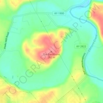
Name: The Backbone topographic map, elevation, terrain.
Location: The Backbone, Franklin County, Kentucky, United States (38.23641 -84.82917 38.23651 -84.82907)
Average elevation: 692 ft
Minimum elevation: 577 ft
Maximum elevation: 876 ft
Kentucky trails, hiking, mountain biking, running and outdoor activities
Other topographic maps
Click on a map to view its topography, its elevation and its terrain.
Jefferson County
The highest point is South Park Hill, elevation 902 feet (275 m), located in the southern part of the county. The lowest point is 383 feet (117 m) along the Ohio River just north of West Point.
Average elevation: 604 ft
Land Between the Lakes National Recreation Area
United States > Kentucky > Trigg County
The United States Army Corps of Engineers constructed a dam on the Cumberland, producing another lake. It was planned to be at the same elevation as Kentucky Lake, and the two rivers were to be connected by a canal that did not require locks. This project was intended to lessen the shipping distances for goods…
Average elevation: 479 ft
Jefferson Memorial Forest
United States > Kentucky > Jefferson County > Louisville
Average elevation: 538 ft
Pine Mountain State Resort Park
United States > Kentucky > Bell County > Pineville
Average elevation: 1,604 ft
Flatwoods
United States > Kentucky > Greenup County
The area now known as Flatwoods was originally named "Advance": Advance Methodist Church formed a Sunday school beginning in 1860. The name was later changed to "Cheap", after John Cheap, a blind clergyman. The original farming community returned to the name of "Advance" when a post office was established in…
Average elevation: 636 ft
Hartford
United States > Kentucky > Ohio County
Several elements of the Downtown Hartford Historic District, including the courthouse, jail and main block of the Hartford City Hall, remain virtually intact on the exterior. As in most downtowns, however, storefronts have suffered the greatest changes. Fortunately, most of the upper elevations of these…
Average elevation: 404 ft
Westwood
United States > Kentucky > Boyd County > Fairview
Westwood is a census-designated place in Boyd County, Kentucky, United States. The population was 4,387 at the 2020 census. A suburb of Ashland, the two areas are closely affiliated, sharing a ZIP code and bus system. Westwood is located on a flat to hilly elevation just west of the Ohio River. The flat…
Average elevation: 630 ft
Eminence
United States > Kentucky > Henry County
According to the United States Census Bureau, the city of Eminence has a total area of 2.9 square miles (7.4 km2), of which 0.04 square miles (0.1 km2), or 1.70%, is water. The city is located on high ground, with elevations up to 960 feet (290 m), where several watersheds converge. The source of the Little…
Average elevation: 899 ft
Breckinridge Center
United States > Kentucky > Union County > Breckinridge Center
Average elevation: 420 ft