
Charles City County topographic map
Interactive map
Click on the map to display elevation.
About this map
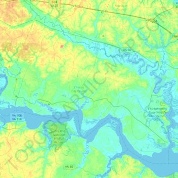
Name: Charles City County topographic map, elevation, terrain.
Location: Charles City County, Virginia, United States (37.22303 -77.27158 37.49059 -76.87177)
Average elevation: 59 ft
Minimum elevation: -7 ft
Maximum elevation: 249 ft
Virginia trails, hiking, mountain biking, running and outdoor activities
Other topographic maps
Click on a map to view its topography, its elevation and its terrain.
Virginia Beach
United States > Virginia > Virginia Beach
Virginia Beach, Virginia, located in the coastal region of the United States, features a predominantly flat terrain characterized by its proximity to the Atlantic Ocean. The elevation is remarkably low, averaging about 10 feet (3 meters) above sea level, which contributes to the area's susceptibility to…
Average elevation: 7 ft
Wattsville
United States > Virginia > Accomack County
It lies at an elevation of 3 feet.
Average elevation: 36 ft
Thousand Trails Chesapeake Bay RV Resort
United States > Virginia > Gloucester County
Average elevation: 33 ft
Rustburg
United States > Virginia > Campbell County
Rustburg is located in north-central Campbell County at 37°16′25″N 79°05′56″W / 37.273731°N 79.098914°W / 37.273731; -79.098914 (37.273731, −79.098914). U.S. Route 501 passes through the center of town, leading north 11 miles (18 km) to Lynchburg and south 20 miles (32 km) to Brookneal.…
Average elevation: 892 ft
Quinby
United States > Virginia > Accomack County
It lies at an elevation of 7 feet.
Average elevation: 3 ft
Kiptopeke State Park
United States > Virginia > Northampton County > Kiptopeke
Average elevation: 20 ft
Robious Landing Park
United States > Virginia > Chesterfield County > Midlothian
Average elevation: 180 ft