
Bob Marshall Wilderness topographic map
Interactive map
Click on the map to display elevation.
Bob Marshall Wilderness
"The Bob", as it is known by locals and nicknamed by the U.S. Forest Service employees, ranges in altitudes of 4,000 to more than 9,000 feet (1,220 to 2750 m). A long escarpment known as the Chinese Wall averages 1,000 feet (300 m) high from its base and extends for 22 miles (35 km). With numerous waterfalls, lakes, and dense forests, the wilderness is prime Grizzly bear habitat; the U.S. Forest Service claims that the population density of this species is higher in "The Bob" than can be found anywhere else in the U.S. outside of the Greater Yellowstone Ecosystem or Alaska. The Bob is also home to many other large mammals, such as moose, elk, black bear, mountain goat, bighorn sheep, wolverine, cougar, Canadian lynx, and wolf. Bald eagles, osprey, pelican, and trumpeter swan are just a few of the bird species found. The dense old-growth forests are dominated by Douglas fir, larch, and spruce. Forest fires have changed large areas in the wilderness complex in recent years.
About this map
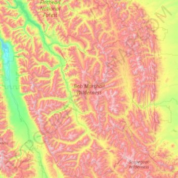
Name: Bob Marshall Wilderness topographic map, elevation, terrain.
Location: Bob Marshall Wilderness, Montana, United States (47.22802 -113.66402 48.16473 -112.69086)
Average elevation: 5,833 ft
Minimum elevation: 3,051 ft
Maximum elevation: 9,134 ft
Montana trails, hiking, mountain biking, running and outdoor activities
Other topographic maps
Click on a map to view its topography, its elevation and its terrain.
Crazy Peak
United States > Montana > Sweet Grass County
Crazy Peak, elevation 11,214 ft (3,418 m), is the highest peak in the Crazy Mountains, an island range of the Montana Rockies, in the United States. Crazy Peak dominates the surroundings, rising over 7,000 feet (2,100 m) above the Yellowstone River Valley, and is the highest peak in Montana north of the…
Average elevation: 9,626 ft
Berkeley Pit
United States > Montana > Silver Bow County > Butte
The mine is at 46°00′56″N 112°30′37″W / 46.01556°N 112.51028°W / 46.01556; -112.51028, at an altitude of 4,698 feet (1432 m) above mean sea level.
Average elevation: 5,614 ft
Bozeman
United States > Montana > Gallatin County
Bozeman is located at an elevation of 4,820 feet (1,470 m). The Bridger Mountains are to the north-northeast, the Tobacco Root Mountains to the west-southwest, the Big Belt Mountains and Horseshoe Hills to the northwest, the Hyalite Peaks of the northern Gallatin Range to the south and the Spanish Peaks of the…
Average elevation: 5,509 ft
Rice Motel and Trailer Court
United States > Montana > Jefferson County > Whitehall
Average elevation: 4,390 ft
Carbon Hill Trailer Court
United States > Montana > Custer County > Miles City
Average elevation: 2,402 ft
Freezout Lake Wildlife Management Area
United States > Montana > Teton County
Average elevation: 3,796 ft
Little Granulated Mountain
United States > Montana > Silver Bow County > Butte
Average elevation: 8,389 ft
Kalispell
United States > Montana > Flathead County > Kalispell
Kalispell is located at 48°11′52″N 114°18′58″W / 48.19778°N 114.31611°W / 48.19778; -114.31611 (48.197801, −114.316068), at an elevation of 2,956 feet (901 m).
Average elevation: 3,461 ft
Lake McDonald
United States > Montana > Flathead County
Lake McDonald is the largest lake in Glacier National Park. It is located at 48°35′N 113°55′W / 48.583°N 113.917°W / 48.583; -113.917 in Flathead County in the U.S. state of Montana. Lake McDonald is approximately 10 miles (16 km) long, and over a mile (1.6 km) wide and 472 feet (130 m) deep,…
Average elevation: 3,967 ft