
Make a donation
Gear up for your next adventure:
As an Amazon Associate, this site earns from qualifying purchases at no extra cost to you.
Zhejiang topographic map
Click on the map to display elevation.
Make a donation
Gear up for your next adventure:
As an Amazon Associate, this site earns from qualifying purchases at no extra cost to you.
Zhejiang
Zhejiang consists mostly of hills, which account for about 70% of its total area, with higher altitudes towards the south and the west. Zhejiang also has a longer coastline than any other mainland province of China. The Qiantang River runs through the province, from which it derives its name. Included in the province are three thousand islands, the most in China. The capital Hangzhou marks the end of the Grand Canal and lies on Hangzhou Bay on the north of Zhejiang, which separates Shanghai and Ningbo. The bay contains many small islands collectively called the Zhoushan Islands.
Make a donation
Gear up for your next adventure:
As an Amazon Associate, this site earns from qualifying purchases at no extra cost to you.
About this map
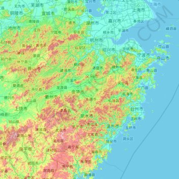
Name: Zhejiang topographic map, elevation, terrain.
Location: Zhejiang, China (26.85910 118.02241 31.18258 123.39362)
Average elevation: 732 ft
Minimum elevation: -7 ft
Maximum elevation: 6,683 ft
Make a donation
Gear up for your next adventure:
As an Amazon Associate, this site earns from qualifying purchases at no extra cost to you.
Other topographic maps
Click on a map to view its topography, its elevation and its terrain.
Guangzhou
China > Guangdong Province > Guangzhou
The elevation of the prefecture generally increases from southwest to northeast, with mountains forming the backbone of the city and the ocean comprising the front. Tiantang Peak (天堂顶, "Heavenly Peak") is the highest point of elevation at 1,210 metres (3,970 ft) above sea level.
Average elevation: 69 ft
Lhasa
Lhasa has an elevation of about 3,600 m (11,800 ft) and lies in the centre of the Tibetan Plateau with the surrounding mountains rising to 5,500 m (18,000 ft). The air only contains 68 percent of the oxygen compared to sea level. The Lhasa River, also Kyi River or Kyi Chu, a tributary of the Yarlung Zangbo…
Average elevation: 14,370 ft
Xi'an
Xi'an lies on the Guanzhong Plain in the south-central part of Shaanxi province, on a flood plain created by the eight surrounding rivers and streams. The city has an average elevation of 400 metres (1,312 ft) above sea level and an annual precipitation of 553 mm (21.8 in). The urban area of Xi'an is located…
Average elevation: 1,352 ft
Make a donation
Gear up for your next adventure:
As an Amazon Associate, this site earns from qualifying purchases at no extra cost to you.
Hong Kong
Hong Kong has a humid subtropical climate (Köppen Cwa), characteristic of southern China. Summer is hot and humid, with occasional showers and thunderstorms and warm air from the southwest. Typhoons occur most often then, sometimes resulting in floods or landslides. Winters are mild and usually sunny at the…
Average elevation: 203 ft
Make a donation
Gear up for your next adventure:
As an Amazon Associate, this site earns from qualifying purchases at no extra cost to you.
Shangri-La
China > Yunnan > Shangri-La > Jiantang
Shangri-La has either a dry-winter, warm-summer humid continental climate (Köppen climate classification: Dwb), or a dry-winter subtropical highland climate (Köppen climate classification: Cwb), both of which are unusually cool by Yunnan standards due to the high elevation, which ranges between 2,700 and…
Average elevation: 12,054 ft
Make a donation
Gear up for your next adventure:
As an Amazon Associate, this site earns from qualifying purchases at no extra cost to you.
Make a donation
Gear up for your next adventure:
As an Amazon Associate, this site earns from qualifying purchases at no extra cost to you.
Make a donation
Gear up for your next adventure:
As an Amazon Associate, this site earns from qualifying purchases at no extra cost to you.
Mischief Reef
China > Hainan Province > Sansha
Mischief Reef, also known as Panganiban Reef (Tagalog: Bahura ng Panganiban; Vietnamese: Đá Vành Khăn; Mandarin Chinese: 美濟礁/美济礁; pinyin: Měijì Jiāo; lit. 'Meiji Reef'), is a low tide elevation (LTE) reef/atoll surrounding a large lagoon in the SE of Dangerous Ground in the east of the…
Average elevation: 0 ft
Batang
It is warmer here than most of Tibet (because of the lower altitude) and is reported to be a friendly, easy-going place, surrounded by barley fields. The plain surrounding the town is unusually fertile and produces two harvests a year. The main products include: rice, maize, barley, wheat, peas, cabbages,…
Average elevation: 12,822 ft
Make a donation
Gear up for your next adventure:
As an Amazon Associate, this site earns from qualifying purchases at no extra cost to you.
Make a donation
Gear up for your next adventure:
As an Amazon Associate, this site earns from qualifying purchases at no extra cost to you.
Make a donation
Gear up for your next adventure:
As an Amazon Associate, this site earns from qualifying purchases at no extra cost to you.
Make a donation
Gear up for your next adventure:
As an Amazon Associate, this site earns from qualifying purchases at no extra cost to you.
Make a donation
Gear up for your next adventure:
As an Amazon Associate, this site earns from qualifying purchases at no extra cost to you.
Longshengzhuang
China > Inner Mongolia > Fengzhen City > Ulanqab City > Longshengzhuang
Average elevation: 4,567 ft
Make a donation
Gear up for your next adventure:
As an Amazon Associate, this site earns from qualifying purchases at no extra cost to you.
Make a donation
Gear up for your next adventure:
As an Amazon Associate, this site earns from qualifying purchases at no extra cost to you.
Grand Canyon South Entrance
China > Anhui > Huangshan District > Alchemy Peak
Average elevation: 4,941 ft
Make a donation
Gear up for your next adventure:
As an Amazon Associate, this site earns from qualifying purchases at no extra cost to you.
Make a donation
Gear up for your next adventure:
As an Amazon Associate, this site earns from qualifying purchases at no extra cost to you.
Chongqing
The central urban area of Chongqing, or Chongqing proper, is a city of unique features. Built on mountains and partially surrounded by the Yangtze and Jialing rivers, it is known as a "mountain city" and a "city on rivers". The night scene of the city is very illuminated, with millions of lights and their…
Average elevation: 1,043 ft
Make a donation
Gear up for your next adventure:
As an Amazon Associate, this site earns from qualifying purchases at no extra cost to you.
Subi Reef
China > Hainan Province > Nansha District
On 12 July 2016, the UNCLOS special arbitral tribunal in the Philippines v. China case confirmed that Subi Reef is, or in its natural condition was, exposed at low tide and submerged at high tide and is, accordingly a low-tide elevation that does not generate entitlement to a territorial sea, exclusive…
Average elevation: 0 ft
Make a donation
Gear up for your next adventure:
As an Amazon Associate, this site earns from qualifying purchases at no extra cost to you.
Make a donation
Gear up for your next adventure:
As an Amazon Associate, this site earns from qualifying purchases at no extra cost to you.
Scarborough Shoal
China > Hainan Province > Sansha
The Philippines state that its assertion of sovereignty over the atoll is based on the juridical criteria established by public international law on the lawful methods for the acquisition of sovereignty. Among the criteria (effective occupation, cession, prescription, conquest, and accretion), the Philippine…
Average elevation: 0 ft
Amur River
China > Heilongjiang > 黑瞎子岛镇
The river rises in the hills in the western part of Northeast China at the confluence of its two major affluents, the Shilka and the Argun (or Ergune), at an elevation of 303 metres (994 ft). It flows east forming the border between China and Russia, and slowly makes a great arc to the southeast for about 400…
Average elevation: 141 ft
Make a donation
Gear up for your next adventure:
As an Amazon Associate, this site earns from qualifying purchases at no extra cost to you.
Make a donation
Gear up for your next adventure:
As an Amazon Associate, this site earns from qualifying purchases at no extra cost to you.
Make a donation
Gear up for your next adventure:
As an Amazon Associate, this site earns from qualifying purchases at no extra cost to you.
Chuen Lung Cha Tau Wo
China > Hong Kong > Tsuen Wan District > Chuen Lung Village
Average elevation: 1,319 ft
Dachaomen
China > Chongqing > Youyang Miao and Tujia Autonomous County > Longtan
Average elevation: 1,650 ft
Make a donation
Gear up for your next adventure:
As an Amazon Associate, this site earns from qualifying purchases at no extra cost to you.
Make a donation
Gear up for your next adventure:
As an Amazon Associate, this site earns from qualifying purchases at no extra cost to you.
Make a donation
Gear up for your next adventure:
As an Amazon Associate, this site earns from qualifying purchases at no extra cost to you.
Make a donation
Gear up for your next adventure:
As an Amazon Associate, this site earns from qualifying purchases at no extra cost to you.
Make a donation
Gear up for your next adventure:
As an Amazon Associate, this site earns from qualifying purchases at no extra cost to you.