
Make a donation
Gear up for your next adventure:
As an Amazon Associate, this site earns from qualifying purchases at no extra cost to you.
Centre topographic map
Click on the map to display elevation.
Make a donation
Gear up for your next adventure:
As an Amazon Associate, this site earns from qualifying purchases at no extra cost to you.
About this map
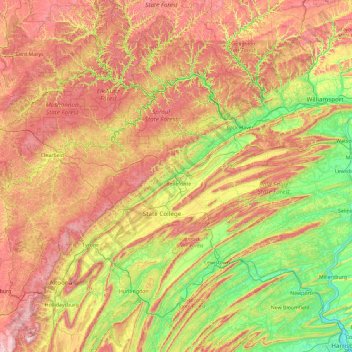
Name: Centre topographic map, elevation, terrain.
Location: Centre, Centre County, Pennsylvania, United States (40.23817 -78.48657 41.63817 -77.08657)
Average elevation: 1,388 ft
Minimum elevation: 292 ft
Maximum elevation: 3,127 ft
Pennsylvania trails, hiking, mountain biking, running and outdoor activities
Make a donation
Gear up for your next adventure:
As an Amazon Associate, this site earns from qualifying purchases at no extra cost to you.
Other topographic maps
Click on a map to view its topography, its elevation and its terrain.
Nesquehoning
United States > Pennsylvania > Carbon County
Nesquehoning is located at 40°52′5″N 75°49′27″W / 40.86806°N 75.82417°W / 40.86806; -75.82417 (40.868178, -75.824176). According to the U.S. Census Bureau, the borough has a total area of 21.6 square miles (56 km2), of which, 21.2 square miles (55 km2) is land and 0.4 square miles (1.0…
Average elevation: 1,207 ft
Codorus State Park
United States > Pennsylvania > York County > Manheim Township
Average elevation: 676 ft
Make a donation
Gear up for your next adventure:
As an Amazon Associate, this site earns from qualifying purchases at no extra cost to you.
Make a donation
Gear up for your next adventure:
As an Amazon Associate, this site earns from qualifying purchases at no extra cost to you.
Big Pocono State Park
United States > Pennsylvania > Monroe County > Pocono Township
Average elevation: 1,388 ft
Hydetown
United States > Pennsylvania > Crawford County
Hydetown Borough is located just south of the southern terminal moraine for glaciation in northwestern Pennsylvania. The borough is drained by Oil Creek, a southward-flowing tributary of the Allegheny River, which runs through the northwestern and southwestern sides of the borough and Thompson Creek, which…
Average elevation: 1,352 ft
Make a donation
Gear up for your next adventure:
As an Amazon Associate, this site earns from qualifying purchases at no extra cost to you.
Pine Township
United States > Pennsylvania > Lycoming County
The villages of Oregon Hill and English Center were founded by survivors of the failed English Settlement. Oregon Hill, at an elevation of 1,700 feet (520 m) in the northern part of the township, was the location of two churches, a blacksmith shop, and two stores along with several homes. The settlers of…
Average elevation: 1,617 ft
Make a donation
Gear up for your next adventure:
As an Amazon Associate, this site earns from qualifying purchases at no extra cost to you.
Aston Township
United States > Pennsylvania > Delaware County > Aston Township
Average elevation: 197 ft
Make a donation
Gear up for your next adventure:
As an Amazon Associate, this site earns from qualifying purchases at no extra cost to you.
Make a donation
Gear up for your next adventure:
As an Amazon Associate, this site earns from qualifying purchases at no extra cost to you.
flood plane
United States > Pennsylvania > Chester County > Uwchlan Township > Lionville
Average elevation: 489 ft
Make a donation
Gear up for your next adventure:
As an Amazon Associate, this site earns from qualifying purchases at no extra cost to you.
Make a donation
Gear up for your next adventure:
As an Amazon Associate, this site earns from qualifying purchases at no extra cost to you.
Potato Creek
United States > Pennsylvania > McKean County > Keating Township
Average elevation: 1,542 ft
Make a donation
Gear up for your next adventure:
As an Amazon Associate, this site earns from qualifying purchases at no extra cost to you.
Shanor-Northvue
United States > Pennsylvania > Butler County > Windward Heights
Average elevation: 1,240 ft
Make a donation
Gear up for your next adventure:
As an Amazon Associate, this site earns from qualifying purchases at no extra cost to you.
Susquehanna Trails
United States > Pennsylvania > York County > Peach Bottom Township
Average elevation: 463 ft
Make a donation
Gear up for your next adventure:
As an Amazon Associate, this site earns from qualifying purchases at no extra cost to you.
Brackenridge
United States > Pennsylvania > Allegheny County
Brackenridge is located at 40°36′30″N 79°44′32″W / 40.60833°N 79.74222°W / 40.60833; -79.74222. The borough's average elevation is 827 feet (252 m) above sea level. According to the U.S. Census Bureau, the borough has a total area of 0.6 square miles (1.6 km2), of which 0.5 square miles…
Average elevation: 873 ft
Make a donation
Gear up for your next adventure:
As an Amazon Associate, this site earns from qualifying purchases at no extra cost to you.
Temple
United States > Pennsylvania > Berks County > Muhlenberg Township
Temple is a census-designated place in Muhlenberg Township, Berks County, Pennsylvania, United States at an elevation of 361 feet (110 m). The community was named for a local inn called Solomon's Temple. Temple was an independent borough until it was disincorporated on January 1, 1999. The ZIP code is 19560.…
Average elevation: 413 ft
Village Green-Green Ridge
United States > Pennsylvania > Delaware County > Aston Township
Average elevation: 157 ft
Linntown
United States > Pennsylvania > Union County > East Buffalo Township > Linntown
Average elevation: 499 ft
Make a donation
Gear up for your next adventure:
As an Amazon Associate, this site earns from qualifying purchases at no extra cost to you.
Make a donation
Gear up for your next adventure:
As an Amazon Associate, this site earns from qualifying purchases at no extra cost to you.
Georges Township
United States > Pennsylvania > Fayette County
Georges Township is in southwestern Fayette County. It surrounds the boroughs of Fairchance (near the center of the township) and Smithfield (in the southwest). Pennsylvania Route 43 (the Mon–Fayette Expressway), U.S. Route 119, and Pennsylvania Route 857 cross the township, running roughly parallel. All…
Average elevation: 1,660 ft
Make a donation
Gear up for your next adventure:
As an Amazon Associate, this site earns from qualifying purchases at no extra cost to you.
Make a donation
Gear up for your next adventure:
As an Amazon Associate, this site earns from qualifying purchases at no extra cost to you.
Make a donation
Gear up for your next adventure:
As an Amazon Associate, this site earns from qualifying purchases at no extra cost to you.
Shenandoah Heights
United States > Pennsylvania > Schuylkill County > West Mahanoy Township
Average elevation: 1,542 ft
Make a donation
Gear up for your next adventure:
As an Amazon Associate, this site earns from qualifying purchases at no extra cost to you.
Make a donation
Gear up for your next adventure:
As an Amazon Associate, this site earns from qualifying purchases at no extra cost to you.
Make a donation
Gear up for your next adventure:
As an Amazon Associate, this site earns from qualifying purchases at no extra cost to you.
Make a donation
Gear up for your next adventure:
As an Amazon Associate, this site earns from qualifying purchases at no extra cost to you.
Make a donation
Gear up for your next adventure:
As an Amazon Associate, this site earns from qualifying purchases at no extra cost to you.
Russellton
United States > Pennsylvania > Allegheny County > West Deer Township
Average elevation: 1,066 ft
Curtisville
United States > Pennsylvania > Allegheny County > West Deer Township > Curtisville
Average elevation: 1,129 ft
Make a donation
Gear up for your next adventure:
As an Amazon Associate, this site earns from qualifying purchases at no extra cost to you.
Make a donation
Gear up for your next adventure:
As an Amazon Associate, this site earns from qualifying purchases at no extra cost to you.
Make a donation
Gear up for your next adventure:
As an Amazon Associate, this site earns from qualifying purchases at no extra cost to you.