
Salaverry topographic map
Click on the map to display elevation.
Salaverry
Abarca una superficie de 295,88 km² y se encuentra ubicado a 14 km al sur de Trujillo a los 8°13´12” de latitud sur y a 78°14´12” de longitud oeste. Tiene una altitud de 3 m s. n. m..
About this map
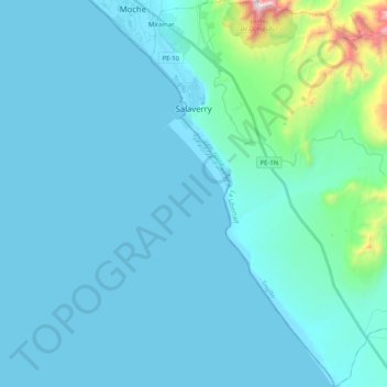
Name: Salaverry topographic map, elevation, terrain.
Location: Salaverry, Trujillo, La Libertad, Perú (-8.37147 -78.99936 -8.16667 -78.80245)
Average elevation: 335 ft
Minimum elevation: -7 ft
Maximum elevation: 3,655 ft
Other topographic maps
Click on a map to view its topography, its elevation and its terrain.
Laguna Sausacocha
Perú > La Libertad > Huamachuco > Sausacocha
El lago se encuentra a una altitud de 3200 m.s.n.m. y cubre el área aproximada de 4 kilómetros cuadrados (1.5 millas cuadradas) rodeada de colinas bajas. Su profundidad varia entre 1.50 metros en la orilla a 12 - 15 metros en el centro y esto permite la navegación de embarcaciones fluviales pequeñas con…
Average elevation: 10,518 ft
Huanchaco
Perú > La Libertad > Huanchaco
En Huanchaco la religión que predomina es el cristianismo, como una costumbre religiosa adquirida desde la época colonial de la cultura española que llegó al lugar. En este ámbito existen diferentes congregaciones que profesan la fe cristiana como la Iglesia católica, los Testigos de Jehová, la Iglesia…
Average elevation: 72 ft
Huamachuco
Perú > La Libertad > Huamachuco
Está situada a una altitud de 3269 m s. n. m. en la vertiente oriental de la cordillera de los Andes, en un valle a 184 km de la ciudad de Trujillo.
Average elevation: 10,673 ft
Trujillo
La ciudad se encuentra ubicada a una altitud media de 34 m s. n. m. en una franja costera occidental de la provincia de Trujillo, en el Valle de Moche o Santa Catalina. La ciudad se encuentra ubicada en la costa norte a una altitud media de 34 m s. n. m. en la margen derecha del río Moche a orillas del…
Average elevation: 699 ft