
Make a donation
Gear up for your next adventure:
As an Amazon Associate, this site earns from qualifying purchases at no extra cost to you.
Çovdar topographic map
Click on the map to display elevation.
Make a donation
Gear up for your next adventure:
As an Amazon Associate, this site earns from qualifying purchases at no extra cost to you.
About this map
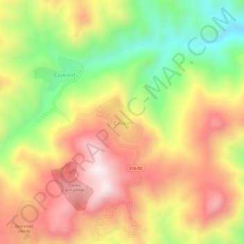
Name: Çovdar topographic map, elevation, terrain.
Location: Çovdar, Dashkasan District, Azerbaijan (40.59427 46.08835 40.63427 46.12835)
Average elevation: 4,514 ft
Minimum elevation: 3,238 ft
Maximum elevation: 5,673 ft
Make a donation
Gear up for your next adventure:
As an Amazon Associate, this site earns from qualifying purchases at no extra cost to you.
Other topographic maps
Click on a map to view its topography, its elevation and its terrain.
Aras River
The lowest point in Armenia is a point along the Aras at an elevation of 380 metres (1,250 ft).
Average elevation: 4,849 ft
Make a donation
Gear up for your next adventure:
As an Amazon Associate, this site earns from qualifying purchases at no extra cost to you.
Make a donation
Gear up for your next adventure:
As an Amazon Associate, this site earns from qualifying purchases at no extra cost to you.
Make a donation
Gear up for your next adventure:
As an Amazon Associate, this site earns from qualifying purchases at no extra cost to you.
Make a donation
Gear up for your next adventure:
As an Amazon Associate, this site earns from qualifying purchases at no extra cost to you.
Shirvan
Throughout its history, Shirvan has suffered from floods because of its proximity to the river and the relatively low elevation of most of the town.
Average elevation: 52 ft
Make a donation
Gear up for your next adventure:
As an Amazon Associate, this site earns from qualifying purchases at no extra cost to you.
Nakhchivan Autonomous Republic
The Republic is rich in minerals. Nakhchivan possesses deposits of marble, lime, and gypsum. The deposits of the rock salt are exhausted in Nehram, Nakhchivan, and Sustin. The important molybdenum mines are currently closed as a consequence of the exclave's isolation. There are a lot of mineral springs such as…
Average elevation: 5,217 ft
Make a donation
Gear up for your next adventure:
As an Amazon Associate, this site earns from qualifying purchases at no extra cost to you.
Shusha
Shusha (Azerbaijani: Şuşa, (listen)) or Shushi (Armenian: Շուշի) is a city in Azerbaijan, in the disputed region of Nagorno-Karabakh. Situated at an altitude of 1,400–1,800 metres (4,600–5,900 ft) in the Karabakh mountains, the city was a mountain resort in the Soviet era.
Average elevation: 4,157 ft
Hadrut Province
Hadrut Province formed the breakaway Republic of Artsakh's southern border and is one of its most mountainous parts. Villages were primarily found along two river valleys and scattered in lower elevations on the very southern fringe. Excavations of the Azokh Cave showed that humans have inhabited this area for…
Average elevation: 3,658 ft
Make a donation
Gear up for your next adventure:
As an Amazon Associate, this site earns from qualifying purchases at no extra cost to you.
Make a donation
Gear up for your next adventure:
As an Amazon Associate, this site earns from qualifying purchases at no extra cost to you.
Qazax
Gazakh region is located in the western part of the republic, in the western part of the vast Ganja-Gazakh plain, which starts from the slopes of the mountain range of the Lesser Caucasus and extends along the right bank of the Kura river. The highest elevation is "Odun" mountain (1316 meters). Its nature is…
Average elevation: 1,253 ft
Nakhchivan
Nakhchivan (Azerbaijani: Naxçıvan [nɑxtʃɯˈvɑn]; Armenian: Նախիջևան, romanized: Nakhijevan) is the capital of the eponymous Nakhchivan Autonomous Republic of Azerbaijan, located 450 km (280 mi) west of Baku. The municipality of Nakhchivan consists of the city of Nakhchivan, the settlement of…
Average elevation: 2,907 ft
Make a donation
Gear up for your next adventure:
As an Amazon Associate, this site earns from qualifying purchases at no extra cost to you.
Make a donation
Gear up for your next adventure:
As an Amazon Associate, this site earns from qualifying purchases at no extra cost to you.
Quba-Khachmaz
The climate of the region has special topographic characteristic with four different zones. Clime types are divided into hot in the plain zones, cold-humid and cold in the mountain zones.
Average elevation: 2,123 ft
Make a donation
Gear up for your next adventure:
As an Amazon Associate, this site earns from qualifying purchases at no extra cost to you.
Make a donation
Gear up for your next adventure:
As an Amazon Associate, this site earns from qualifying purchases at no extra cost to you.
Make a donation
Gear up for your next adventure:
As an Amazon Associate, this site earns from qualifying purchases at no extra cost to you.
Make a donation
Gear up for your next adventure:
As an Amazon Associate, this site earns from qualifying purchases at no extra cost to you.