
Prefectura de Yamaguchi topographic map
Interactive map
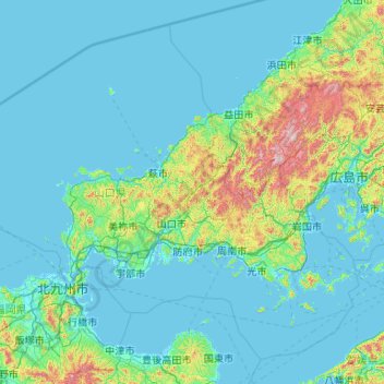
Click on the map to display elevation.
About this map
Name: Prefectura de Yamaguchi topographic map, elevation, terrain.
Location: Prefectura de Yamaguchi, Japón (33.55291 130.39786 35.07831 132.51124)
Average elevation: 404 ft
Minimum elevation: -13 ft
Maximum elevation: 4,324 ft
Other topographic maps
Click on a map to view its topography, its elevation and its terrain.
Monte Fuji
Japón > Distrito de Sunto > Oyama
Monte Fuji, Oyama, Distrito de Sunto, Prefectura de Shizuoka, Japón
Average elevation: 10,699 ft
Oshima
Japón > Subprefectura de Oshima > Tokio > Oshima
Oshima, Subprefectura de Oshima, Tokio, 100-0103, Japón
Average elevation: 33 ft
日光市
Japón > Prefectura de Tochigi > 日光市 > 日光市
日光市, Prefectura de Tochigi, 関東地方, 3211273, Japón
Average elevation: 1,850 ft