Geolocate

Oregon topographic map

Interactive map

Click on the map to display elevation.

Oregon

Oregon's topography is strikingly diverse, characterized by an array of geographical features that shape its unique landscape. The state is framed by two significant mountain ranges: the Pacific Coast Range to the west and the Cascade Mountains running north to south through the center. This mountainous terrain gives rise to the fertile Willamette Valley, renowned for its agricultural productivity. To the east of the Cascades, the landscape transforms into high desert and scrublands, typifying the semiarid climate of eastern Oregon, which contrasts sharply with the lush forests and cooler temperatures found in the west. The state's highest point is Mount Hood, reaching an elevation of 11,249 feet (3,428 meters), contributing to the dramatic elevation changes across the region​. The coastline stretches for 363 miles (584 kilometers), showcasing rugged cliffs and scenic beaches, further enhancing Oregon's varied terrain.

About this map

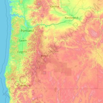
Name: Oregon topographic map, elevation, terrain.

Location: Oregon, United States (41.99179 -124.70354 46.29239 -116.46315)

Average elevation: 3,077 ft

Minimum elevation: -10 ft

Maximum elevation: 13,681 ft

United States trails, hiking, mountain biking, running and outdoor activities

Other topographic maps

Click on a map to view its topography, its elevation and its terrain.

Portland

United States > Oregon > Multnomah County

Portland features a striking and varied topography characterized by its location at the confluence of the Willamette and Columbia Rivers. The city lies within the fertile Willamette Valley, flanked by the snow-capped Cascade Mountains to the east, including the prominent Mount Hood, and the less elevated…

Average elevation: 253 ft

Seattle

United States > Washington > King County

Seattle features a diverse topography characterized by its unique geographical setting between Puget Sound and Lake Washington. The city is situated on an isthmus, which contributes to its dramatic landscape, featuring rolling hills and steep slopes that rise abruptly from the waterfront. The average elevation…

Average elevation: 131 ft

New York

United States > New York

New York City's topography is a fascinating blend of varied elevations and unique landscapes, reflecting its diverse geography across five boroughs. Situated at the confluence of the Hudson and East Rivers, the city primarily features low-lying terrain, with the average elevation hovering around sea level.…

Average elevation: 62 ft

San Francisco

United States > California

San Francisco is characterized by its striking and varied topography, making it one of the most distinctive cities in the United States. The landscape features a mix of rolling hills and steep inclines, with the highest elevation reaching approximately 922 feet at Twin Peaks. The average elevation across the…

Average elevation: 207 ft

Eugene

United States > Oregon > Lane County

Eugene is characterized by a varied topography that contributes to its picturesque landscapes. The city sits at an average elevation of about 426 feet (130 meters) and is nestled within the Willamette Valley, surrounded by the foothills of the Cascade Mountains to the east, which rise significantly in…

Average elevation: 535 ft

Tampa

United States > Florida > Hillsborough County

Tampa is characterized by a predominantly flat topography, with an average elevation around 16 to 49 feet above sea level. The terrain is marked by low-lying areas and gentle slopes, with the highest points in the vicinity reaching approximately 62 feet. This landscape is interspersed with numerous water…

Average elevation: 36 ft

Austin

United States > Texas > Travis County

Austin features a diverse and varied topography shaped by its position along the Balcones Fault. The city’s elevation ranges from about 425 feet to approximately 1,000 feet above sea level, creating a landscape characterized by rolling hills and elevated areas particularly in the western regions. To the…

Average elevation: 709 ft

Arizona

United States

Arizona's topography is highly diverse, shaped by three distinct regions: the Colorado Plateau, the Basin and Range Province, and the Transition Zone. The northern Colorado Plateau is characterized by flat, high plains over 4,000 feet in elevation, including the Grand Canyon and its breathtaking cliffs. In…

Average elevation: 4,032 ft

Gresham

United States > Oregon > Multnomah County

Though much of Gresham is relatively flat, it is characterized by a hill on its eastern border. Northeast Gresham is also hilly, particularly where the city meets Troutdale toward the Columbia River. Its elevation is 325 feet (99 m). Johnson Creek, which begins at the foothills of the Cascade Mountains, runs…

Average elevation: 295 ft

Ohio

United States

Ohio's topography is characterized by a diverse landscape that ranges from the flat plains in the north to the rolling hills and rugged terrain in the southeast. The state can be divided into several distinct regions, including the Great Lakes Plains to the north, the Central Plains in the west, and the…

Average elevation: 912 ft

Atlanta

United States > Georgia > Fulton County

Atlanta features a varied topography characterized by its rolling hills and elevated terrain. The city sits at an average elevation of approximately 1,050 feet (320 meters) above sea level, with elevations ranging from about 725 feet (221 meters) to 1,175 feet (358 meters) in the surrounding areas​. This…

Average elevation: 932 ft

Oregon City

United States > Oregon > Clackamas County

Average elevation: 325 ft

San Diego

United States > California > San Diego County

San Diego is characterized by a diverse topography that features coastal plains, rolling hills, and rugged mountain ranges. The city is situated along the Pacific Ocean, where it boasts an extensive shoreline with sandy beaches and tidal zones. As you move inland, the landscape transitions from the flat…

Average elevation: 410 ft

Virginia

United States

Virginia's topography is characterized by a diverse landscape that transitions from the Atlantic Coastal Plain in the east to the mountainous regions in the west. The Coastal Plain features flat, low-lying areas that gradually rise to the Piedmont, known for its rolling hills and valleys. Further west, the…

Average elevation: 814 ft

Lake Oswego

United States > Oregon > Clackamas County

Average elevation: 285 ft

Salem

United States > Oregon > Marion County

Salem is situated in the heart of the Willamette Valley and features a varied topography shaped by its proximity to notable geological formations. The city itself is primarily located at an elevation of around 177 feet (54 meters), but it spans a range from approximately 120 to 800 feet (37 to 244 meters)…

Average elevation: 315 ft

Louisville

United States > Kentucky > Jefferson County

Louisville features a diverse topography shaped by the Ohio River and surrounding landscape. The city lies at an elevation of approximately 466 feet (142 meters) and is characterized by rolling hills and valleys, with the highest point in the county reaching about 902 feet (275 meters) at South Park Hill in…

Average elevation: 617 ft

Saint Petersburg

United States > Florida > Pinellas County

Saint Petersburg features a predominantly flat topography characteristic of the Gulf Coast region. The city's elevation averages around 44 feet (approximately 13.4 meters) above sea level, with some areas dipping to about 15 feet (4.6 meters)​. This relatively low elevation contributes to the area's…

Average elevation: 13 ft

Florida

United States

Florida's topography is characterized by its predominantly flat landscape, with the highest elevation being Britton Hill at just 345 feet above sea level, making it the lowest high point of any U.S. state. The state is primarily divided into three physiographic regions: the Atlantic Coastal Plain, the East…

Average elevation: 20 ft

Denver

United States > Colorado > Denver County > Denver

Denver, situated at an elevation of 5,280 feet (1,609 meters), is renowned as the "Mile High City." It is located in the South Platte River Valley, just east of the Rocky Mountains' foothills. The city's topography features a gently sloping landscape characterized by rolling hills and wide valleys,…

Average elevation: 5,525 ft

California

United States

California's topography is characterized by a remarkable diversity that includes expansive mountain ranges, deep valleys, and vast deserts. The Sierra Nevada mountains dominate the eastern part of the state, with peaks such as Mount Whitney rising to 14,494 feet, making it the tallest point in the contiguous…

Average elevation: 3,048 ft

Tennessee

United States

Tennessee features a diverse and varied topography characterized by its distinct regions, which include the Appalachian Mountains, the Central Basin, and the Gulf Coastal Plain. The state’s highest point is Clingmans Dome, rising to about 6,643 feet above sea level, while the lowest point is along the…

Average elevation: 764 ft

Michigan

United States

Michigan's topography is characterized by a diverse landscape that transitions from flat plains to rugged hills. The state comprises two peninsulas, with the Upper Peninsula showcasing more pronounced elevation changes, including its highest point, Mount Arvon, which rises to 1,979 feet (603 meters). In…

Average elevation: 850 ft

North Carolina

United States

North Carolina features a diverse topography that can be divided into three distinct regions: the Coastal Plain, the Piedmont, and the Appalachian Mountains. The Coastal Plain, which occupies the eastern part of the state, is characterized by flat and gently sloping land, with elevations typically less than…

Average elevation: 535 ft

Ashland

United States > Oregon > Jackson County

Ashland lies within Oregon's southwest interior climate zone, in which all but the higher-elevation sites are in the rain shadow of the Oregon Coast Range to the west. The largest urban areas in this zone in addition to Ashland are Medford and Grants Pass in the Rogue Valley, and Roseburg in the Umpqua River…

Average elevation: 2,539 ft

Phoenix

United States > Arizona > Maricopa County

Phoenix is characterized by a unique topographical landscape nestled in the Salt River Valley. This valley, at an average elevation of about 1,086 feet, is framed by several prominent mountain ranges, creating a striking contrast between the flat plains and elevated terrains​. Notable peaks such as Camelback…

Average elevation: 1,578 ft

Pittsburgh

United States > Pennsylvania > Allegheny County

Pittsburgh, located in Allegheny County, Pennsylvania, is characterized by its distinct and varied topography, shaped by the confluence of the Allegheny, Monongahela, and Ohio rivers. The city itself is situated at an average elevation of approximately 764 feet (233 meters) above sea level, with the terrain…

Average elevation: 994 ft

Puerto Rico

United States > Puerto Rico

Puerto Rico features a diverse topography characterized by a mountainous interior, coastal plains, and stunning beaches. The island's central region is dominated by the Cordillera Central mountain range, which includes the highest peak, Cerro de Punta, rising to 4,390 feet (1,338 meters). These mountains…

Average elevation: 213 ft

Tigard

United States > Oregon > Washington County

Average elevation: 272 ft

Port Orchard

United States > Washington > Kitsap County

Average elevation: 233 ft

Columbia

United States > South Carolina > Richland County

Columbia features a relatively gentle and rolling topography. The elevation in this area varies, with the city itself situated around 318 feet above sea level, while the surrounding regions exhibit elevations that can reach as high as 573 feet. The landscape is characterized by a mix of low-lying areas and…

Average elevation: 292 ft

Anchorage

United States > Alaska > Anchorage

Average elevation: 1,037 ft

Salt Lake City

United States > Utah > Salt Lake County

Salt Lake City's topography is characterized by a striking contrast between its flat valley floor and the surrounding rugged mountains. The city is situated in the Salt Lake Valley, with an average elevation of approximately 4,237 feet above sea level, making it one of the higher major cities in the United…

Average elevation: 5,223 ft

Grants Pass

United States > Oregon > Josephine County

Average elevation: 1,227 ft

Texas

United States

Texas showcases a diverse and expansive topography that spans approximately 268,000 square miles, making it the second-largest state in the United States. The landscape ranges from the arid deserts of West Texas, characterized by broad valleys and mesas, to the rolling hills of the Texas Hill Country, where…

Average elevation: 1,699 ft

Kansas City

United States > Missouri > Jackson County

Kansas City features a diverse topography characterized by rolling hills and valleys, with elevations ranging from about 794 to 997 feet above sea level. The landscape is shaped by the confluence of the Missouri and Kansas rivers, resulting in a mix of elevated areas and flat river plains. The region's average…

Average elevation: 909 ft

Summit

United States > New Jersey > Union County

Average elevation: 318 ft

Las Cruces

United States > New Mexico > Doña Ana County

The approximate elevation of Las Cruces is 3,908 feet (1,191 m) above sea level.

Average elevation: 4,255 ft

Mount Pocono

United States > Pennsylvania > Monroe County

Average elevation: 1,762 ft

Omaha

United States > Nebraska > Douglas County

Omaha features a varied topography characterized by rolling hills and valleys that rise gently from the Missouri River, which forms the city's eastern boundary. The landscape is primarily composed of prairie and hardwood forests, offering a mix of open spaces and wooded areas. Elevations within the city range…

Average elevation: 1,109 ft

Dunedin

United States > Florida > Pinellas County

Dunedin is characterized by a predominantly flat terrain, with an average elevation of approximately 13 feet (4 meters) above sea level, making it typical of the coastal regions of Pinellas County. The area's topography is defined by its proximity to the Gulf of Mexico, which influences its gently rolling…

Average elevation: 36 ft

Nashville-Davidson

United States > Tennessee > Davidson County

Nashville-Davidson, features a diverse topography characterized by its position in the Nashville Basin and the Highland Rim. The terrain is predominantly hilly, with elevations ranging from approximately 385 feet at the Cumberland River to around 1,163 feet in areas like Radnor Lake State Natural Area. This…

Average elevation: 604 ft

San Antonio

United States > Texas > Bexar County

San Antonio features a diverse topography characterized by gently rolling hills and flat plains. The city's elevation averages around 650 feet above sea level, but nearby areas can reach heights of up to 1,300 feet in certain locations like Cross Mountain​. The landscape is part of the southern edge of the…

Average elevation: 810 ft

Raleigh

United States > North Carolina > Wake County

Raleigh features a topography primarily defined by its position along the fall line, which is the geological boundary between the Piedmont and Coastal Plain regions. This area experiences a gradual elevation drop of approximately 150 to 350 feet over a distance of 1 to 3 miles as one moves eastward. The city's…

Average elevation: 338 ft

Kentucky

United States

Kentucky's topography is characterized by a diverse landscape that varies significantly across its regions. The state features rolling hills, plateaus, and mountainous areas, particularly in the eastern section where the Cumberland Plateau rises to the highest point at Black Mountain, which reaches 4,139 feet…

Average elevation: 991 ft

Colorado

United States

Colorado's topography is characterized by a diverse range of elevations and landforms, making it one of the most geologically varied states in the U.S. The state is dominated by the Rocky Mountains, which run north to south and include the highest peak in the contiguous United States, Mount Elbert, towering at…

Average elevation: 6,759 ft

Pinellas County

United States > Florida

Pinellas County features a predominantly flat terrain, characterized by low-lying coastal plains that rise gently from the shores of the Gulf of Mexico. The highest points in the county reach around 60 feet above sea level, primarily found in the northern sections. The area is interspersed with numerous water…

Average elevation: 13 ft

El Paso

United States > Texas > El Paso County

El Paso is characterized by a diverse and striking topography shaped by its desert environment and mountainous landscapes. The city is situated at an average elevation of approximately 3,700 feet above sea level, surrounded by the rugged Franklin Mountains to the west, where peaks exceed 7,000 feet​. This…

Average elevation: 4,058 ft

Beaverton

United States > Oregon > Washington County

As of January 2020, Beaverton covers a total area of 19.7 square miles (51 km2), all of it land except for small creeks, ponds, and lakes. The city is located along the eastern edge of the Tualatin Valley just west of the Tualatin Mountains. It is bordered by Portland to the east, Hillsboro to the west, and…

Average elevation: 348 ft

Hillsboro

United States > Oregon > Washington County

Hillsboro is located at 45°31′N 122°59′W / 45.517°N 122.983°W / 45.517; -122.983 (Hillsboro, Oregon). The United States Census Bureau reports the city has a total area of 21.6 square miles (55.9 km2), all of which is land. In 2013, Hillsboro itself reported an area of 23.88 square miles…

Average elevation: 174 ft

Greenville

United States > South Carolina > Greenville County

Greenville features a varied topography characterized by rolling hills and the nearby Blue Ridge Mountains. The city sits at an elevation of approximately 984 feet (300 meters) above sea level, with its landscape shaped significantly by the Reedy River, which flows through the heart of downtown, creating…

Average elevation: 951 ft

South Carolina

United States

South Carolina's topography is defined by three major geographic regions: the Atlantic Coastal Plain, the Piedmont, and the Blue Ridge Mountains. Covering approximately two-thirds of the state, the Atlantic Coastal Plain is characterized by flat, gently rolling terrain that transitions from the sandy beaches…

Average elevation: 279 ft

San Francisco Bay Area

United States > California > San Francisco

The San Francisco Bay Area is characterized by a diverse and dynamic topography shaped by geological processes over millions of years. This region features a combination of coastal plains, steep hills, and rugged mountains, all influenced by the tectonic activity associated with the nearby San Andreas Fault…

Average elevation: 371 ft

Gatlinburg

United States > Tennessee > Sevier County

Gatlinburg is nestled within the Appalachian Mountains, specifically at the junction of the Ridge-and-Valley and the Blue Ridge provinces, making its topography notably rugged and varied. The town itself sits at an elevation of approximately 1,500 feet above sea level, surrounded by steep ridges and deep…

Average elevation: 1,893 ft

Houston

United States > Texas > Harris County

Houston is characterized by its predominantly flat topography, sitting at an average elevation of approximately 59 feet (18 meters) above sea level. The city is situated on the Gulf Coastal Plain, which is dissected by a network of bayous that contribute to the region's drainage. This terrain was once covered…

Average elevation: 82 ft

Bonney Lake

United States > Washington > Pierce County

Average elevation: 502 ft

Bakersfield

United States > California > Kern County

Most of Bakersfield's major streets are six-lane divided roads with bike lanes, with almost every street in the city having proper lane signage for bicycle traffic. Bikes are a popular method of transportation in Bakersfield, due to the city's relatively flat topography and grid-like street system. Newer…

Average elevation: 515 ft

Roanoke

United States > Virginia

Roanoke is characterized by a diverse topography, nestled within the Appalachian Mountains and the scenic Blue Ridge region. The city is situated at an elevation of approximately 1,100 feet, with the surrounding terrain consisting of rolling hills and valleys, predominantly shaped by the nearby Roanoke River.…

Average elevation: 1,093 ft

Charlotte

United States > North Carolina > Mecklenburg County

Charlotte, located in the Piedmont region of North Carolina, features a gently rolling terrain characterized by elevations ranging from approximately 650 to 700 feet (198 to 213 meters). The city is bordered to the west by the Catawba River, which contributes to the area's mild climate and lush vegetation.…

Average elevation: 679 ft

Reno

United States > Nevada > Washoe County

Reno is characterized by its diverse topography, which is shaped by its elevation and the surrounding mountain ranges. Situated at an average elevation of approximately 4,500 feet (about 1,370 meters), the city is nestled in a high desert region that features a mix of flat valleys and gently rolling hills​.…

Average elevation: 5,413 ft

Fort Collins

United States > Colorado > Larimer County

Fort Collins is situated at an elevation of approximately 5,003 feet (1,524 meters) above sea level, nestled at the base of the Rocky Mountains in northern Colorado. The city features a varied topography characterized by gently rolling plains that gradually rise to foothills, creating a picturesque backdrop.…

Average elevation: 5,079 ft

Tucson

United States > Arizona > Pima County

Tucson is situated on an alluvial plain in the Sonoran Desert, at an elevation of approximately 2,400 feet (730 meters) above sea level. The city is enveloped by five mountain ranges, which contribute significantly to its varied topography. To the north lie the Santa Catalina and Tortolita Mountains, while the…

Average elevation: 2,697 ft

West Virginia

United States

West Virginia is renowned for its mountainous terrain, primarily part of the Appalachian Mountain system. The state's topography is characterized by steep ridges, deep valleys, and rugged plateaus. The Allegheny Plateau dominates much of the western and central regions, with its dissected hills and valleys,…

Average elevation: 1,411 ft

Missouri

United States

Missouri's topography is marked by a diverse array of landforms that contribute to its unique landscape. The state is characterized by four main physiographic regions: the Ozark Plateau, Dissected Till Plains, Mississippi Alluvial Plain, and the Osage Plains. The Ozark Plateau, located in the south, features…

Average elevation: 827 ft

Parnell

United States > Kentucky > Wayne County

Average elevation: 951 ft

Gulfport

United States > Florida > Pinellas County

Average elevation: 23 ft

Tucson

United States > Arizona > Pima County > Tucson

The city's elevation is 2,643 ft (806 m) above sea level (as measured at the Tucson International Airport). Tucson is on an alluvial plain in the Sonoran Desert, surrounded by five minor ranges of mountains: the Santa Catalina Mountains and the Tortolita Mountains to the north, the Santa Rita Mountains to the…

Average elevation: 2,743 ft

Washington County

United States > Oregon

Average elevation: 699 ft

Martha's Vineyard

United States > Massachusetts > Dukes County > West Tisbury

Martha's Vineyard features a diverse topography characterized by gently rolling hills, sandy beaches, and rugged coastline. The island spans approximately 100 square miles and boasts elevations that reach up to 289 feet at its highest point, offering panoramic views of the surrounding Atlantic Ocean. The…

Average elevation: 10 ft

Maui

United States > Hawaii > Maui County

Maui County's topography is characterized by a dramatic blend of volcanic mountains, rolling hills, and stunning coastal regions, creating a diverse landscape that contributes to its unique beauty. The island's centerpiece is Haleakalā, a massive shield volcano rising to an elevation of 10,023 feet, which is…

Average elevation: 761 ft

Joshua Tree National Park

United States > California > Riverside County

Joshua Tree National Park is an American national park in southeastern California, east of San Bernardino and Los Angeles and north of Palm Springs. It is named after the Joshua trees (Yucca brevifolia) native to the Mojave Desert. Originally declared a national monument in 1936, Joshua Tree was redesignated…

Average elevation: 2,096 ft

Grimes County

United States > Texas

Average elevation: 289 ft

Bay County

United States > Florida

Average elevation: 43 ft

Grand Canyon National Park

United States > Arizona > Mohave County

The topography of Grand Canyon National Park is defined by dramatic elevations and striking geological features. The park, located in Mohave County, Arizona, encompasses over 278 miles of the Colorado River and its surrounding plateaus. The canyon itself reaches depths of more than a mile (6,000 feet) from rim…

Average elevation: 5,528 ft

Manatee County

United States > Florida

Manatee County features a varied topography characterized by flat coastal plains, gently rolling hills, and numerous waterways. The county’s landscape is predominantly low-lying, with elevations typically ranging from sea level to about 100 feet above sea level, making it susceptible to flooding during heavy…

Average elevation: 43 ft

San Jose

United States > California > Santa Clara County

San Jose, located in Santa Clara County, California, features a diverse topography characterized by a mix of low-lying plains and rolling hills. The city sits at an average elevation of approximately 82 feet (25 meters) above sea level, with the surrounding terrain including the foothills of the Santa Cruz…

Average elevation: 866 ft

Miami

United States > Florida > Miami-Dade County

Miami is characterized by its unique topography, which features a broad coastal plain lying between the expansive Everglades to the west and the tranquil waters of Biscayne Bay to the east. The average elevation across the city is approximately 16 feet (5 meters) above sea level, with some areas dipping…

Average elevation: 16 ft

Aiken

United States > South Carolina > Aiken County

Average elevation: 440 ft

West Chester

United States > Pennsylvania > Chester County

Average elevation: 413 ft

Abilene

United States > Texas > Taylor County

Average elevation: 1,749 ft

Boone

United States > North Carolina > Watauga County

Boone, located in Watauga County, North Carolina, is set within the rugged Appalachian Mountains, specifically the Blue Ridge range. With an elevation of approximately 3,300 feet (1,016 meters), it stands as one of the highest towns of its size in the eastern United States. The terrain is dominated by steep…

Average elevation: 3,507 ft

Buffalo

United States > New York > Erie County

Buffalo is characterized by its relatively flat terrain, predominantly lying on the Erie/Ontario Lake Plain, which forms part of the Eastern Great Lakes Lowlands. The city's elevation averages around 607 feet above sea level, with minor variations, particularly in neighborhoods like University Heights, which…

Average elevation: 607 ft

Cleveland

United States > Ohio > Cuyahoga County

Cleveland features a diverse topography shaped significantly by its proximity to Lake Erie and the Cuyahoga River. The city is characterized by a rapid elevation change, with the lakefront sitting at approximately 569 feet above sea level. Just inland, Public Square rises to about 650 feet, while further from…

Average elevation: 705 ft

Traverse City

United States > Michigan > Grand Traverse County

The locale and topography is conducive for road bicycling, aided by the TART trail system. A map with routes, different trips, advice and local knowledge is available. Lake Michigan presents a location for sailing, fishing, and kayaking.

Average elevation: 669 ft

Midwest

United States > Wyoming > Natrona County

The town of Midwest, located in Natrona County, Wyoming, sits in a relatively flat, semi-arid landscape characterized by the rolling hills and gentle slopes typical of the Great Plains region. The area's topography is largely defined by expansive grasslands and isolated buttes. Midwest is positioned near…

Average elevation: 4,862 ft

Louisiana

United States

Louisiana's topography is defined by a variety of landscapes that reflect both its coastal and inland characteristics. Much of the state consists of low-lying plains, including the Mississippi Alluvial Plain, where the fertile soils of the delta create an area vital for agriculture. The eastern region near the…

Average elevation: 128 ft

Idaho

United States

Idaho's topography is characterized by its remarkable diversity, featuring vast mountain ranges, deep river canyons, and extensive plains. The state is home to over 75 mountain ranges, including the prominent Rocky Mountains and the majestic Sawtooth Range, with peaks like Borah Peak rising to 12,662 feet…

Average elevation: 5,030 ft

Searsport

United States > Maine > Waldo County

Average elevation: 167 ft

Yucca Valley

United States > California > San Bernardino County

Yucca Valley lies in the middle of the Morongo Basin at a base elevation of 3,300 feet. Joshua Tree National Park is adjacent to its southern border.

Average elevation: 3,629 ft

Lane County

United States > Oregon

Lane County showcases a strikingly diverse topography that spans a wide range of elevations and geological features. This area extends from sea level along the picturesque Pacific coastline to the towering peaks of the Cascade Mountains, where elevations exceed 10,000 feet. The western region is characterized…

Average elevation: 2,336 ft

Richmond

United States > Virginia

Average elevation: 161 ft

Lake Tahoe

United States > California > Placer County

Lake Tahoe is renowned for its dramatic topography, characterized by rugged mountain ranges and deep, crystal-clear waters. Nestled in the Sierra Nevada, the lake itself lies at an elevation of approximately 6,225 feet (1,897 meters) and spans about 22 miles (35 kilometers) in length and 12 miles (19…

Average elevation: 6,814 ft

Shenandoah National Park

United States > Virginia > Page County

Shenandoah National Park lies along the Blue Ridge Mountains in north-central Virginia. These mountains form a distinct highland rising to elevations above 4,000 feet (1,200 m). Local topographic relief between the Blue Ridge Mountains and Shenandoah Valley exceeds 3,000 feet (910 m) at some locations. The…

Average elevation: 1,099 ft

Wyoming

United States

Wyoming's topography is characterized by a dramatic and varied landscape that includes vast mountain ranges, expansive plateaus, and intermontane basins. The state is predominantly mountainous, with the Rocky Mountains covering a significant portion of its western region. Here, the Wind River Range rises to…

Average elevation: 6,358 ft

Clemson

United States > South Carolina > Pickens County

Average elevation: 735 ft

Fort Myers

United States > Florida > Lee County

Fort Myers, located in Lee County, Florida, features a predominantly flat topography characterized by low elevations, averaging around 10 to 16 feet (approximately 3 to 5 meters) above sea level. The area is primarily composed of coastal plains, which contribute to its lush, subtropical vegetation and…

Average elevation: 16 ft

Auburn

United States > Washington > King County

Average elevation: 289 ft

Stillwater

United States > Oklahoma > Payne County

Average elevation: 938 ft