
Make a donation
Gear up for your next adventure:
As an Amazon Associate, this site earns from qualifying purchases at no extra cost to you.
Germany topographic map
Click on the map to display elevation.
Make a donation
Gear up for your next adventure:
As an Amazon Associate, this site earns from qualifying purchases at no extra cost to you.
Germany
Germany's topography is remarkably diverse, showcasing a blend of lowlands, uplands, and mountainous regions. In the north, the North German Plain extends across vast stretches of flat, fertile land, which supports extensive agriculture, particularly wheat and dairy farming. This area is characterized by gentle hills and several important rivers, including the Elbe and Weser, which meander through the landscape. Moving southward, the terrain rises into the Central German Uplands, featuring hilly plateaus and ranges like the Harz and Ore Mountains. This region is dotted with picturesque valleys and is home to several historic towns. The southernmost part of Germany, dominated by the Bavarian Alps, includes the country's highest peak, Zugspitze, reaching 9,718 feet (2,962 meters). Here, rugged mountains and glacial lakes offer dramatic scenery and recreational opportunities such as hiking and skiing. This varied topography not only shapes the climate but also influences cultural and economic activities across the country.
Make a donation
Gear up for your next adventure:
As an Amazon Associate, this site earns from qualifying purchases at no extra cost to you.
About this map
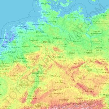
Name: Germany topographic map, elevation, terrain.
Location: Germany (47.27011 5.86632 55.09916 15.04193)
Average elevation: 778 ft
Minimum elevation: -23 ft
Maximum elevation: 9,003 ft
Make a donation
Gear up for your next adventure:
As an Amazon Associate, this site earns from qualifying purchases at no extra cost to you.
Other topographic maps
Click on a map to view its topography, its elevation and its terrain.
Africa
Africa's topography is a complex tapestry of plateaus, mountains, valleys, and deserts. The continent is dominated by vast plateaus, with elevations averaging around 1,000 meters (3,281 feet), especially prominent in the south and east. The Ethiopian Highlands, often referred to as the "Roof of Africa," rise…
Average elevation: 1,516 ft
San Francisco Bay Area
United States > California > San Francisco
The San Francisco Bay Area is characterized by a diverse and dynamic topography shaped by geological processes over millions of years. This region features a combination of coastal plains, steep hills, and rugged mountains, all influenced by the tectonic activity associated with the nearby San Andreas Fault…
Average elevation: 371 ft
North America
North America's topography is characterized by its diverse and dramatic landscapes, stretching from the towering Rocky Mountains in the west to the expansive Great Plains in the central region, and the rugged Appalachian Mountains in the east. The Rocky Mountains, which include peaks exceeding 20,000 feet…
Average elevation: 965 ft
Make a donation
Gear up for your next adventure:
As an Amazon Associate, this site earns from qualifying purchases at no extra cost to you.
Atlanta
United States > Georgia > Fulton County
Atlanta (/ætˈlæntə/ at-LAN-tə) is the capital and most populous city of the U.S. state of Georgia. It is the seat of Fulton County, the most populous county in Georgia. With a population of 498,715 living within the city limits, it is the eighth most populous city in the Southeast and 38th most populous…
Average elevation: 935 ft
City of London
United Kingdom > England > City of London > City of London
The elevation of the City ranges from sea level at the Thames to 21.6 metres (71 ft) at the junction of High Holborn and Chancery Lane. Two small but notable hills are within the historic core, Ludgate Hill to the west and Cornhill to the east. Between them ran the Walbrook, one of the many "lost" rivers or…
Average elevation: 138 ft
Englewood
Englewood features a diverse topography characterized by flat coastal plains and gently rolling terrain. The area is predominantly low-lying, with elevations rarely exceeding 20 feet above sea level, making it susceptible to tidal influences from the Gulf of Mexico. The landscape is interspersed with wetlands,…
Average elevation: 10 ft
Make a donation
Gear up for your next adventure:
As an Amazon Associate, this site earns from qualifying purchases at no extra cost to you.
Santa Cruz Mountains
United States > California > Santa Clara County
The Santa Cruz Mountains are a region of great biological diversity, encompassing cool, moist coastal ecosystems as well as warm, dry chaparral. Much of the area in the Santa Cruz mountains is considered temperate rainforest. In valleys and moist ocean-facing slopes some of the southernmost coast redwoods…
Average elevation: 755 ft
Make a donation
Gear up for your next adventure:
As an Amazon Associate, this site earns from qualifying purchases at no extra cost to you.
Make a donation
Gear up for your next adventure:
As an Amazon Associate, this site earns from qualifying purchases at no extra cost to you.
Istanbul
Istanbul, located in northwestern Turkey, is a city that is uniquely situated across two continents, Europe and Asia, divided by the Bosphorus Strait. The city’s topography is characterized by a complex blend of hills, valleys, and coastal plains, which create a varied and scenic landscape. The European side…
Average elevation: 187 ft
Birmingham
United Kingdom > England > Birmingham
Birmingham is a snowy city relative to other large UK conurbations, due to its inland location and comparatively high elevation. Between 1961 and 1990 Birmingham Airport averaged 13.0 days of snow lying annually, compared to 5.33 at London Heathrow. Snow showers often pass through the city via the Cheshire gap…
Average elevation: 427 ft
Make a donation
Gear up for your next adventure:
As an Amazon Associate, this site earns from qualifying purchases at no extra cost to you.
Tucson
United States > Arizona > Pima County > Tucson
The city's elevation is 2,643 ft (806 m) above sea level (as measured at the Tucson International Airport). Tucson is on an alluvial plain in the Sonoran Desert, surrounded by five minor ranges of mountains: the Santa Catalina Mountains and the Tortolita Mountains to the north, the Santa Rita Mountains to the…
Average elevation: 2,743 ft
Pollock Pines
United States > California > El Dorado County
Pollock Pines is a census-designated place (CDP) in El Dorado County, California, United States. It is part of the Sacramento–Arden-Arcade–Roseville Metropolitan Statistical Area. Pollock Pines lies at an elevation of 3,980 feet (1,210 m) in the Sierra Nevada. The population was 6,871 at the 2010 census,…
Average elevation: 3,681 ft
Evergreen
United States > Colorado > Jefferson County
Evergreen sits at an elevation of 7,220 feet (2,200 m) in the Rocky Mountains, 19 miles west of Denver, Colorado. Its addresses are oriented according to the Street_system_of_Denver.
Average elevation: 7,575 ft
Make a donation
Gear up for your next adventure:
As an Amazon Associate, this site earns from qualifying purchases at no extra cost to you.
Make a donation
Gear up for your next adventure:
As an Amazon Associate, this site earns from qualifying purchases at no extra cost to you.
Taurus Mountains
The mountains have a Mediterranean climate, with dry summers and rainy winters. Temperatures vary with elevation, with warm winters on the lower coastal slopes and cold winters in the high mountains and in the interior.
Average elevation: 2,717 ft
Yucca Valley
United States > California > San Bernardino County
Yucca Valley lies in the middle of the Morongo Basin at a base elevation of 3,300 feet. Joshua Tree National Park is adjacent to its southern border.
Average elevation: 3,629 ft
Make a donation
Gear up for your next adventure:
As an Amazon Associate, this site earns from qualifying purchases at no extra cost to you.
Port Charlotte
United States > Florida > Charlotte County
Port Charlotte is characterized by a predominantly flat and low-lying terrain, typical of Florida’s coastal landscape. The area features a network of waterways, including the Peace River and Charlotte Harbor, which provide ample opportunities for recreational activities like boating and fishing. Elevations…
Average elevation: 13 ft
Europe
Europe's topography is characterized by a striking contrast between its rugged southern mountains and the expansive plains of the north. The continent is often described as a "peninsula of peninsulas," featuring major peninsulas like the Iberian, Italian, and Balkan, each with unique geological features. In…
Average elevation: 732 ft
Athens
Greece > Attica > Regional Unit of Central Athens
Owing to the rain shadow of the Pindus Mountains, annual precipitation of Athens is lower than most other parts of Greece, especially western Greece. As an example, Ioannina receives around 1,300 mm (51 in) per year, and Agrinio around 800 mm (31 in) per year. Daily average highs for July have been measured…
Average elevation: 551 ft
Make a donation
Gear up for your next adventure:
As an Amazon Associate, this site earns from qualifying purchases at no extra cost to you.
Flagstaff
United States > Arizona > Coconino County
Flagstaff, located in Coconino County, Arizona, is characterized by its diverse topography, primarily shaped by its high elevation and volcanic activity. Sitting at around 7,000 feet (approximately 2,130 meters), the city is surrounded by the expansive Coconino National Forest, which features a blend of…
Average elevation: 7,139 ft
Lipa
Philippines > Batangas > Lipa > Lipa
At the celebration of the elevation of Lipa to a city in January 1888, José Rizal was invited by Dr. Jose Lozada, Catalino Dimayuga and the brothers Celestino and Simeon Luz but Rizal responded only with his Hymno Al Trabajo which he dedicated to the zeal and industry of the Lipeños.
Average elevation: 535 ft
Make a donation
Gear up for your next adventure:
As an Amazon Associate, this site earns from qualifying purchases at no extra cost to you.
Appalachian Mountains
United States > North Carolina > Yancey County
The Appalachian Mountains (French: Appalaches), often called the Appalachians, are a system of mountains in eastern to northeastern North America. The Appalachians first formed roughly 480 million years ago during the Ordovician Period. They once reached elevations similar to those of the Alps and the Rocky…
Average elevation: 4,800 ft
South America
South America's topography is marked by remarkable diversity and dramatic contrasts. The continent is dominated by the Andes mountain range, which runs along its western edge, stretching over 4,300 miles from Venezuela to Chile. These mountains are home to some of the highest peaks in the Western Hemisphere,…
Average elevation: 928 ft
Washington, D.C.
United States of America > Washington, D.C. > Washington, D.C.
The highest natural elevation in the District is 409 feet (125 m) above sea level at Fort Reno Park in upper northwest Washington. The lowest point is sea level at the Potomac River. The geographic center of Washington is near the intersection of 4th and L Streets NW.
Average elevation: 207 ft
Make a donation
Gear up for your next adventure:
As an Amazon Associate, this site earns from qualifying purchases at no extra cost to you.
Mount Saint Helens
United States > Washington > Skamania County
The Mount St. Helens major eruption of May 18, 1980 remains the deadliest and most economically destructive volcanic event in U.S. history. Fifty-seven people were killed; 200 homes, 47 bridges, 15 miles (24 km) of railways, and 185 miles (298 km) of highway were destroyed. A massive debris avalanche,…
Average elevation: 6,877 ft
La Jolla
United States > California > San Diego County > San Diego > La Jolla
Average elevation: 121 ft
Johannesburg
South Africa > Gauteng > City of Johannesburg Metropolitan Municipality
Johannesburg is located in the eastern plateau area of South Africa known as the Highveld, at an elevation of 1,753 metres (5,751 ft). The former Central Business District is located on the southern side of the prominent ridge called the Witwatersrand (English: White Water's Ridge) and the terrain falls to the…
Average elevation: 5,299 ft
Make a donation
Gear up for your next adventure:
As an Amazon Associate, this site earns from qualifying purchases at no extra cost to you.
Thousand Oaks
United States > California > Ventura County > Thousand Oaks
The northern parts consist of mountainous terrain in the Simi Hills, Conejo Mountains and Mount Clef Ridge. Narrow canyons such as Hill Canyon cut through the steeper mountainous areas. Conejo Mountain and Conejo Grade are found in westernmost Newbury Park, while the southernmost parts of Thousand Oaks are…
Average elevation: 994 ft
Indianapolis
United States > Indiana > Indianapolis
Indianapolis is within the Tipton Till Plain, a flat to gently sloping terrain underlain by glacial deposits known as till. The lowest point in the city is about 650 feet (198 m) above mean sea level, with the highest natural elevation at about 900 feet (274 m) above sea level. Few hills or short ridges, known…
Average elevation: 791 ft
Make a donation
Gear up for your next adventure:
As an Amazon Associate, this site earns from qualifying purchases at no extra cost to you.
Boise
United States > Idaho > Ada County
Boise (locally /ˈbɔɪsi/ BOY-see) is the capital and most populous city of the U.S. state of Idaho and is the county seat of Ada County. As of the 2020 census, there were 235,684 people residing in the city. On the Boise River in southwestern Idaho, it is 41 miles (66 km) east of the Oregon border and 110…
Average elevation: 3,412 ft
Grand Canyon
United States > Arizona > Coconino County
Uplift associated with mountain formation later moved these sediments thousands of feet upward and created the Colorado Plateau. The higher elevation has also resulted in greater precipitation in the Colorado River drainage area, but not enough to change the Grand Canyon area from being semi-arid. The uplift…
Average elevation: 3,356 ft
Mauna Kea
United States > Hawaii > Hawaiʻi County
Mauna Kea (/ˌmaʊnə ˈkeɪə/; Hawaiian: [ˈmɐwnə ˈkɛjə]; abbreviation for Mauna a Wākea) is a dormant volcano on the island of Hawaiʻi. Its peak is 4,207.3 m (13,803 ft) above sea level, making it the highest point in the state of Hawaiʻi and second-highest peak of an island on Earth. The peak is…
Average elevation: 13,051 ft
Make a donation
Gear up for your next adventure:
As an Amazon Associate, this site earns from qualifying purchases at no extra cost to you.
Baltimore
Baltimore exhibits a diverse topography that plays a significant role in its character and development. Situated along the Patapsco River, which flows into the Chesapeake Bay, the city is positioned on the fall line that separates the Piedmont Plateau to the west from the Atlantic Coastal Plain to the east.…
Average elevation: 213 ft
Make a donation
Gear up for your next adventure:
As an Amazon Associate, this site earns from qualifying purchases at no extra cost to you.
Austria
According to the Köppen Climate Classification Austria has the following climate types: Oceanic (Cfb), Cool/Warm-summer humid continental (Dfb), Subarctic/Subalpine (Dfc), Tundra/Alpine (ET), and Ice-Cap (EF). It is important to note though that Austria may experience very cold, severe winters, but most of…
Average elevation: 1,096 ft
East Texas
United States > Pennsylvania > Lehigh County > Lower Macungie Township
Average elevation: 413 ft
Make a donation
Gear up for your next adventure:
As an Amazon Associate, this site earns from qualifying purchases at no extra cost to you.
Snoqualmie Pass
United States > Washington > King County
Due to its elevation, Snoqualmie Pass experiences significantly lower temperatures than Seattle, and receives much more precipitation, much of it being snow. Snoqualmie Pass has a humid continental climate (Koppen: Dsb bordering Csb) with cold, very wet and snowy winters, and mild to warm, relatively dry…
Average elevation: 3,438 ft
Make a donation
Gear up for your next adventure:
As an Amazon Associate, this site earns from qualifying purchases at no extra cost to you.
Großglockner
Austria > Carinthia > Bezirk Spittal an der Drau > Heiligenblut am Großglockner
The Glockner is the highest mountain in the Alps east of the Ortler range, about 175 km (109 mi) away, and, after Mont Blanc, has the second greatest topographic isolation of all mountains in the Alps. Even its topographic prominence, at 2,424 m (7,953 ft), is the second highest after Mont Blanc in the entire…
Average elevation: 10,262 ft
Make a donation
Gear up for your next adventure:
As an Amazon Associate, this site earns from qualifying purchases at no extra cost to you.
Himalayas
Nepal > Koshi Province > Solukhumbu
The Himalayas present a dramatic and varied topography characterized by towering peaks, deep valleys, and extensive glaciers. This majestic mountain range features some of the highest elevations on Earth, including Mount Everest, which rises to 29,035 feet. The terrain is marked by steep, jagged ridges and…
Average elevation: 24,787 ft
Hilo
United States of America > Hawaii > Hilo
Hilo has a tropical rainforest climate (Köppen Af), with substantial rainfall throughout the year. Its location on the windward coast (relative to the trade winds), makes it the fourth-wettest city in the United States, behind the southeast Alaskan cities of Whittier, Ketchikan and Yakutat, and one of the…
Average elevation: 1,027 ft
Navarre
United States > Florida > Santa Rosa County
Navarre is located at 30°24′04″N 86°51′47″W / 30.401°N 86.863°W / 30.401; -86.863Coordinates: 30°24′04″N 86°51′47″W / 30.401°N 86.863°W / 30.401; -86.863. It is located within a portion of the Florida Panhandle observing the Central Time Zone. Elevation is at an average of 10 feet (3.0 m).
Average elevation: 13 ft
Kathmandu
Nepal > Bagmati Province > Kathmandu
Kathmandu is located at an elevation of approximately 4,600 feet (1,400 meters) within the Kathmandu Valley. This valley is characterized by a bowl-like topography, encircled by the lower Himalayan ranges, which rise sharply in the north, culminating in peaks that exceed 24,000 feet (7,300 meters). The…
Average elevation: 5,046 ft
Make a donation
Gear up for your next adventure:
As an Amazon Associate, this site earns from qualifying purchases at no extra cost to you.
Tijuana
Mexico > Baja California > Municipio de Tijuana
Housing development in the Tijuana Hills has led to eradication of many seasonal mountain streams. This lack of natural drainage makes places within the city vulnerable to landslides during the rainy season. The varied terrain of Tijuana gives the city elevation extremes that range from sea level to 790 meters…
Average elevation: 463 ft
Grass Valley
United States of America > California > Grass Valley
The city of Grass Valley is the largest city in the western region of Nevada County, California, United States. Situated at roughly 2,500 feet (760 m) elevation in the western foothills of the Sierra Nevada mountain range, this historic northern Gold Country city is 57 miles (92 km) by car from the state…
Average elevation: 2,549 ft
Augusta
United States > Georgia > Augusta
As with the rest of the state, Augusta has a humid subtropical climate (Köppen Cfa), with short, mild winters, very hot, humid summers, and a wide diurnal temperature variation throughout much of the year, despite its low elevation and moisture. The monthly daily average temperature ranges from 45.4 °F (7.4…
Average elevation: 295 ft
Make a donation
Gear up for your next adventure:
As an Amazon Associate, this site earns from qualifying purchases at no extra cost to you.
Lotissement Le Clos de Kersioual
France > Brittany > Finistère > Port-la-Forêt
Average elevation: 82 ft
Make a donation
Gear up for your next adventure:
As an Amazon Associate, this site earns from qualifying purchases at no extra cost to you.
Oued El Ogla
Morocco > Casablanca-Settat > Pachalik de El Mansouria > El Mansouria
Average elevation: 49 ft
Make a donation
Gear up for your next adventure:
As an Amazon Associate, this site earns from qualifying purchases at no extra cost to you.
Deir Atiya
Syria > Rif Dimashq Governorate
Deir Atiyah enjoys a moderate climate in summer and cold in the winter as it is located at an altitude of 1,250 metres (4,100 ft) above sea level.
Average elevation: 4,160 ft
Make a donation
Gear up for your next adventure:
As an Amazon Associate, this site earns from qualifying purchases at no extra cost to you.
Coachella Valley
United States > California > Riverside County > Palm Desert
The area is surrounded on the southwest by the Santa Rosa Mountains, by the San Jacinto Mountains to the west, the Little San Bernardino Mountains to the east and San Gorgonio Mountain to the north. These mountains peak at around 11,000 feet (3,400 m) and tend to average between 5,000 and 7,000 feet (1,500 and…
Average elevation: 236 ft
Hudson
United States > Florida > Hudson
Hudson features a predominantly flat and low-lying topography typical of the region, with an average elevation of approximately 16 feet above sea level. This terrain is interspersed with various wetlands and small lakes, creating a rich ecosystem that supports diverse wildlife. The area also includes a few…
Average elevation: 16 ft
Make a donation
Gear up for your next adventure:
As an Amazon Associate, this site earns from qualifying purchases at no extra cost to you.
Argentine Pass
United States > Colorado > Summit County
Argentine Pass, elevation 13,207 ft (4,025 m), is a high mountain pass that crosses the Continental Divide in the Front Range of the Rocky Mountains of central Colorado in the United States. Argentine Pass is located on the crest of the Front Range along the boundary southwest of Georgetown and is the highest…
Average elevation: 12,457 ft
Cathedral Rock
United States > Washington > Kittitas County
Cathedral Rock is an intrusive andesite volcanic complex. The Alpine Lakes Wilderness features some of the most rugged topography in the Cascade Range with craggy peaks and ridges, deep glacial valleys, and granite walls spotted with over 700 mountain lakes. Geological events occurring many years ago created…
Average elevation: 5,075 ft
Cathedral Rock
United States > Arizona > Yavapai County
Cathedral Rock is a natural sandstone butte near Sedona, Arizona, United States, and one of the most-photographed sights in the state. The rock formation is located in Coconino National Forest in Yavapai County, about 1 mile (1.6 km) west of State Route 179 (SR 179), and about 2.5 mi (4.0 km) south of the "Y"…
Average elevation: 4,206 ft
Make a donation
Gear up for your next adventure:
As an Amazon Associate, this site earns from qualifying purchases at no extra cost to you.