
Germany topographic map
Click on the map to display elevation.
Germany
Germany's topography is remarkably diverse, showcasing a blend of lowlands, uplands, and mountainous regions. In the north, the North German Plain extends across vast stretches of flat, fertile land, which supports extensive agriculture, particularly wheat and dairy farming. This area is characterized by gentle hills and several important rivers, including the Elbe and Weser, which meander through the landscape. Moving southward, the terrain rises into the Central German Uplands, featuring hilly plateaus and ranges like the Harz and Ore Mountains. This region is dotted with picturesque valleys and is home to several historic towns. The southernmost part of Germany, dominated by the Bavarian Alps, includes the country's highest peak, Zugspitze, reaching 9,718 feet (2,962 meters). Here, rugged mountains and glacial lakes offer dramatic scenery and recreational opportunities such as hiking and skiing. This varied topography not only shapes the climate but also influences cultural and economic activities across the country.
About this map
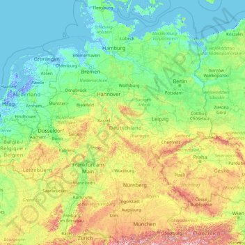
Name: Germany topographic map, elevation, terrain.
Location: Germany (47.27011 5.86632 55.09916 15.04193)
Average elevation: 778 ft
Minimum elevation: -23 ft
Maximum elevation: 9,003 ft
Other topographic maps
Click on a map to view its topography, its elevation and its terrain.
San Francisco Bay Area
United States > California > San Francisco
The San Francisco Bay Area is characterized by a diverse and dynamic topography shaped by geological processes over millions of years. This region features a combination of coastal plains, steep hills, and rugged mountains, all influenced by the tectonic activity associated with the nearby San Andreas Fault…
Average elevation: 371 ft
Atlanta
United States > Georgia > Fulton County
Atlanta occupies a high, rolling part of the Georgia Piedmont, a physiographic region described as a landscape of low hills and narrow valleys between the Blue Ridge Mountains and the Upper Coastal Plain. Around downtown and Fulton County, the terrain is gently dissected rather than flat, with broad urban…
Average elevation: 935 ft
Boise
United States > Idaho > Ada County
Boise (locally /ˈbɔɪsi/ BOY-see) is the capital and most populous city of the U.S. state of Idaho and is the county seat of Ada County. As of the 2020 census, there were 235,684 people residing in the city. On the Boise River in southwestern Idaho, it is 41 miles (66 km) east of the Oregon border and 110…
Average elevation: 3,412 ft
Europe
Europe's topography is characterized by a striking contrast between its rugged southern mountains and the expansive plains of the north. The continent is often described as a "peninsula of peninsulas," featuring major peninsulas like the Iberian, Italian, and Balkan, each with unique geological features. In…
Average elevation: 732 ft
Cincinnati
United States > Ohio > Hamilton County
Cincinnati has several standard modes of transportation including sidewalks, roads, public transit, bicycle paths and airports. The city's hills preclude the regular street grid common to many cities built up in the 19th century, and outside of the downtown basin, regular street grids are rare except for in…
Average elevation: 738 ft
North America
North America's topography is characterized by its diverse and dramatic landscapes, stretching from the towering Rocky Mountains in the west to the expansive Great Plains in the central region, and the rugged Appalachian Mountains in the east. The Rocky Mountains, which include peaks exceeding 20,000 feet…
Average elevation: 965 ft
Flagstaff
United States > Arizona > Coconino County
Flagstaff, located in Coconino County, Arizona, is characterized by its diverse topography, primarily shaped by its high elevation and volcanic activity. Sitting at around 7,000 feet (approximately 2,130 meters), the city is surrounded by the expansive Coconino National Forest, which features a blend of…
Average elevation: 7,139 ft
Baltimore
Baltimore exhibits a diverse topography that plays a significant role in its character and development. Situated along the Patapsco River, which flows into the Chesapeake Bay, the city is positioned on the fall line that separates the Piedmont Plateau to the west from the Atlantic Coastal Plain to the east.…
Average elevation: 213 ft
City of London
United Kingdom > England > City of London > City of London
The elevation of the City ranges from sea level at the Thames to 21.6 metres (71 ft) at the junction of High Holborn and Chancery Lane. Two small but notable hills are within the historic core, Ludgate Hill to the west and Cornhill to the east. Between them ran the Walbrook, one of the many "lost" rivers or…
Average elevation: 138 ft
Port Charlotte
United States > Florida > Charlotte County
Port Charlotte is characterized by a predominantly flat and low-lying terrain, typical of Florida’s coastal landscape. The area features a network of waterways, including the Peace River and Charlotte Harbor, which provide ample opportunities for recreational activities like boating and fishing. Elevations…
Average elevation: 13 ft
Evergreen
United States > Colorado > Jefferson County
Evergreen sits at an elevation of 7,220 feet (2,200 m) in the Rocky Mountains, 19 miles west of Denver, Colorado. Its addresses are oriented according to the Street_system_of_Denver.
Average elevation: 7,575 ft
Fairbanks
United States > Alaska > Fairbanks North Star
Fairbanks is situated within the central Tanana Valley, characterized by a diverse and dynamic topography. The city straddles the Chena River, which flows southwest into the larger Tanana River, defining Fairbanks' southern border. To the north, a gradual incline leads into a chain of hills that ascend toward…
Average elevation: 479 ft
Gulf of Mexico
Average elevation: 66 ft
Twentynine Palms
United States > California > Twentynine Palms
According to the United States Census Bureau, the city has a total area of 59.1 square miles (153 km2), all land. The city is at an elevation of 1,988 feet (606 m). The Marine Corps Air Ground Combat Center Twentynine Palms is located there.
Average elevation: 2,264 ft
Africa
Africa's topography is a complex tapestry of plateaus, mountains, valleys, and deserts. The continent is dominated by vast plateaus, with elevations averaging around 1,000 meters (3,281 feet), especially prominent in the south and east. The Ethiopian Highlands, often referred to as the "Roof of Africa," rise…
Average elevation: 1,516 ft
Air Force Academy
United States > Colorado > El Paso County > Colorado Springs
The campus of the academy covers 18,455 acres (29 sq mi; 75 km2) on the east side of the Rampart Range of the Rocky Mountains, just north of Colorado Springs. Its elevation is normally given as 7,258 feet (2,212 m) above sea level, which is at the cadet area. The academy was designed by Skidmore, Owings and…
Average elevation: 7,080 ft
Palm Harbor
United States > Florida > Pinellas County
Palm Harbor is characterized by its unique topography, which features a relatively rare hilly landscape for the region. Unlike much of the surrounding areas in Pinellas County, which are predominantly flat, Palm Harbor includes elevations that can reach up to about 75 feet above sea level. This elevation gives…
Average elevation: 30 ft
Yucca Valley
United States > California > San Bernardino County
Yucca Valley lies in the middle of the Morongo Basin at a base elevation of 3,300 feet. Joshua Tree National Park is adjacent to its southern border.
Average elevation: 3,629 ft
Dallas
United States > Texas > Dallas County
Dallas and its surrounding area are mostly flat. The city lies at elevations ranging from 450 to 550 feet (137 to 168 m) above sea level. The western edge of the Austin Chalk Formation, a limestone escarpment (also known as the "White Rock Escarpment"), rises 230 feet (70 m) and runs roughly north–south…
Average elevation: 518 ft
Albuquerque
United States > New Mexico > Bernalillo County
Albuquerque is located in north-central New Mexico. To its east are the Sandia–Manzano Mountains. The Rio Grande flows north to south through its center, while the West Mesa and Petroglyph National Monument make up the western part of the city. Albuquerque has one of the highest elevations of any major city…
Average elevation: 5,482 ft
Tucson
United States > Arizona > Pima County > Tucson
The city's elevation is 2,643 ft (806 m) above sea level (as measured at the Tucson International Airport). Tucson is on an alluvial plain in the Sonoran Desert, surrounded by five minor ranges of mountains: the Santa Catalina Mountains and the Tortolita Mountains to the north, the Santa Rita Mountains to the…
Average elevation: 2,743 ft
Indianapolis
United States > Indiana > Indianapolis
Indianapolis is within the Tipton Till Plain, a flat to gently sloping terrain underlain by glacial deposits known as till. The lowest point in the city is about 650 feet (198 m) above mean sea level, with the highest natural elevation at about 900 feet (274 m) above sea level. Few hills or short ridges, known…
Average elevation: 791 ft
East Hampton
United States > New York > Suffolk County > East Hampton > Village of East Hampton
Average elevation: 39 ft
Kathmandu
Nepal > Bagmati Province > Kathmandu
Kathmandu is located at an elevation of approximately 4,600 feet (1,400 meters) within the Kathmandu Valley. This valley is characterized by a bowl-like topography, encircled by the lower Himalayan ranges, which rise sharply in the north, culminating in peaks that exceed 24,000 feet (7,300 meters). The…
Average elevation: 5,046 ft
Dundalk
United States > Maryland > Baltimore County
Most of Dundalk is flat and very near sea level, with a few small hills close to the city of Baltimore to the west. Dundalk is part of the Atlantic Coastal Plain. Elevations range from sea level on the shore of the Chesapeake Bay to approximately 40 feet (12 m) above sea level along the northern reaches of…
Average elevation: 108 ft
Parrish
United States > Florida > Manatee County
Parrish features a predominantly flat terrain with an average elevation of approximately 36 feet above sea level. The area's landscape is characterized by gently rolling hills and low-lying regions, making it typical of the Central Florida topography. Surrounding Parrish are numerous wetlands and drainage…
Average elevation: 39 ft
El Dorado Hills
United States > California > El Dorado County > Cameron Park
El Dorado Hills (EDH), as defined by the 2010 census-designated place (CDP), is at the western border of El Dorado County, between the City of Folsom and the unincorporated community of Cameron Park. The northern limits of the CDP are Folsom Lake and the South Fork of the American River, where river rafters…
Average elevation: 833 ft
Scottish Highlands
United Kingdom > Scotland > Highland
The Scottish Highlands are renowned for their rugged, mountainous terrain that dominates much of the region. Stretching across the northern and central parts of Scotland, the landscape is shaped by ancient geological forces, including the Caledonian Orogeny, which caused significant tectonic collisions…
Average elevation: 2,976 ft
Englewood
Englewood features a diverse topography characterized by flat coastal plains and gently rolling terrain. The area is predominantly low-lying, with elevations rarely exceeding 20 feet above sea level, making it susceptible to tidal influences from the Gulf of Mexico. The landscape is interspersed with wetlands,…
Average elevation: 10 ft
Crowley Lake
United States > California > Mono County
Crowley Lake is a census-designated place in Mono County, California. Crowley Lake sits at an elevation of 6,939 feet (2,115 m). The 2020 United States census reported Crowley Lake's population was 980.
Average elevation: 7,385 ft
Saint Petersburg
United States > Florida > Pinellas County > Saint Petersburg
Average elevation: 10 ft
Appalachian Mountains
United States > North Carolina > Yancey County
The Appalachian Mountains (French: Appalaches), often called the Appalachians, are a system of mountains in eastern to northeastern North America. The Appalachians first formed roughly 480 million years ago during the Ordovician Period. They once reached elevations similar to those of the Alps and the Rocky…
Average elevation: 4,800 ft
Lake of the Woods
United States > Oregon > Klamath County
Lake of the Woods is located near the crest of the Cascade Mountains in western Klamath County, Oregon. Its elevation is 4,949 feet (1,508 m) above sea level. The lake is surrounded by the Fremont–Winema National Forest. Lake of the Woods is 33 miles (53 km) west of Klamath Falls and 43 miles (69 km) east of…
Average elevation: 5,210 ft
Grand Lake
United States > Colorado > Grand County
Established in 1881, Grand Lake sits at an elevation of 8,369 feet (2,551 m) and derives its name from the lake on whose shores it is situated: Grand Lake, the largest natural body of water in Colorado. The town of Grand Lake was originally an outfitting and supply point for the mining settlements of Lulu…
Average elevation: 8,629 ft
Augusta
United States > Georgia > Augusta
As with the rest of the state, Augusta has a humid subtropical climate (Köppen Cfa), with short, mild winters, very hot, humid summers, and a wide diurnal temperature variation throughout much of the year, despite its low elevation and moisture. The monthly daily average temperature ranges from 45.4 °F (7.4…
Average elevation: 295 ft
Echo Summit
United States > California > El Dorado County
Echo Summit is notable for being the location (sometimes listed as "South Lake Tahoe") of the 1968 U.S. Olympic track and field trials for men, held September 6–16, a month before the 1968 Olympics in Mexico City. (The women's trials were at low altitude in Los Angeles County, at Walnut.) The Echo Summit…
Average elevation: 7,218 ft
Las Cruces
United States > New Mexico > Doña Ana County > Las Cruces
The approximate elevation of Las Cruces is 3,908 feet (1,191 m) above sea level.
Average elevation: 4,314 ft
Snoqualmie Pass
United States > Washington > King County
Due to its elevation, Snoqualmie Pass experiences significantly lower temperatures than Seattle, and receives much more precipitation, much of it being snow. Snoqualmie Pass has a humid continental climate (Koppen: Dsb bordering Csb) with cold, very wet and snowy winters, and mild to warm, relatively dry…
Average elevation: 3,438 ft
San Fernando Valley
United States > California > Los Angeles County > Los Angeles
Average elevation: 1,627 ft
Ruby Mountains
United States > Nevada > Elko County
The Ruby Mountains (Shoshoni: 'Duka Doya', meaning “Snowcapped”) are a mountain range, primarily located within Elko County with a small extension into White Pine County, in Nevada, United States. Most of the range is included within the Humboldt-Toiyabe National Forest. The range reaches a maximum…
Average elevation: 6,437 ft
Pinetop-Lakeside
United States > Arizona > Navajo County
Pinetop-Lakeside is nestled in the stunning White Mountains of northeastern Arizona, characterized by a varied topography that significantly influences its natural beauty and recreational opportunities. The terrain features elevations averaging around 6,795 feet, with rugged mountain landscapes interspersed…
Average elevation: 6,847 ft