
Austria topographic map
Click on the map to display elevation.
Austria
According to the Köppen Climate Classification Austria has the following climate types: Oceanic (Cfb), Cool/Warm-summer humid continental (Dfb), Subarctic/Subalpine (Dfc), Tundra/Alpine (ET), and Ice-Cap (EF). It is important to note though that Austria may experience very cold, severe winters, but most of the time they are only around as cold as those in somewhat comparable climate zones, for example Southern Scandinavia or Eastern Europe. As well, at higher altitudes, summers are usually considerably cooler than in the valleys/lower altitudes. The subarctic and tundra climates seen around the Alps are much warmer in winter than what is normal elsewhere due in part to the Oceanic influence on this part of Europe.
About this map
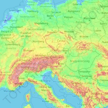
Name: Austria topographic map, elevation, terrain.
Location: Austria (40.59397 7.12456 54.59397 21.12456)
Average elevation: 1,096 ft
Minimum elevation: -20 ft
Maximum elevation: 13,510 ft
Other topographic maps
Click on a map to view its topography, its elevation and its terrain.
Mittersill
Austria > Salzburg > Bezirk Zell am See
It has traffic links running east to west and north to south. The Felbertauern road tunnel runs south through the Hohe Tauern at an elevation of about 1630 m, providing a connection with Lienz in East Tyrol. To the north lies the Thurn Pass at an elevation of 1274 m, providing a connection with Kitzbühel and…
Average elevation: 5,673 ft
Gosau
Austria > Upper Austria > Bezirk Gmunden
Gosau is situated along the Gosaubach stream in the Salzkammergut region. The center of the town is at an elevation of 767m (2,516'). 58.9% of the municipality is forested. At the southern end of Gosau there is a road leading to the Vorderer Gosausee, a lake with a view of the Dachstein.
Average elevation: 4,383 ft
Gerlos
Austria > Tyrol > Bezirk Schwaz
Gerlos is located in the de:Gerlostal, which is a side valley of the Zillertal, branching to the east near Zell am Ziller. Gerlos consists of several hamulated located along the de:Gerlospass on the floor of the valley, at an altitude of around 1200m. To the south, the side valleys of de:Schwarzach,…
Average elevation: 6,319 ft
Landeck
Austria > Tyrol > Bezirk Landeck
Landeck is located in the Tyrolean Oberland in the west of the state at an elevation of about 820 m (2,690 ft). The town is situated in the valley of the Inn River at the confluence with the Sanna tributary, between the Lechtal Alps, part of the Northern Limestone Alps in the north, and the Ötztal Alps and…
Average elevation: 4,347 ft
2122
Austria > Lower Austria > Bezirk Mistelbach > Ulrichskirchen-Schleinbach
Average elevation: 791 ft
Steyr
The city is situated in the Traunviertel region, with the two rivers Steyr and Enns flowing through it and meeting near the town centre beneath Lamberg Castle and St Michael's Church. This prominent location has made it prone to severe flooding through the centuries until the present, one of the worst cases…
Average elevation: 1,119 ft
Wachau Cultural Landscape
Austria > Lower Austria > Bezirk Krems
The Danube valley in Austria between the cities of Melk and Krems in Lower Austria is called the Wachau. This stretch of the valley includes the hills and the adjacent Dunkelsteiner Wald (Dunkelsteiner Forest) and the southern Waldviertel. The Danube river flows north-northeast from Melk to Dürnstein through…
Average elevation: 1,594 ft
Katastralgemeinde Ebreichsdorf
Austria > Lower Austria > Bezirk Baden > Ebreichsdorf
Average elevation: 663 ft
Burg Hochosterwitz
Austria > Carinthia > Bezirk Sankt Veit an der Glan > Launsdorf > Hochosterwitz
Average elevation: 1,864 ft
Gemeinde Payerbach
Austria > Lower Austria > Bezirk Neunkirchen > Gemeinde Payerbach
Average elevation: 2,526 ft
Schloss Klaus
Austria > Upper Austria > Bezirk Kirchdorf > Klaus an der Pyhrnbahn
Average elevation: 2,221 ft
Friesach
Austria > Carinthia > Bezirk Sankt Veit an der Glan
Friesach covers an area of 120.83 km2 and its mean elevation is 631 meters above sea level. It is located in northern Carinthia near the border with Styria, about 40 km (25 mi) north of its capital Klagenfurt.
Average elevation: 3,425 ft
Lake Wolfgang
Austria > Salzburg > Bezirk Salzburg-Umgebung > Sankt Gilgen
Average elevation: 2,769 ft
Gemeinde Lech
Austria > Vorarlberg > Bezirk Bludenz
The altitude of 1444 m for the village refers to the location of the old church on a hill. 14.1% of the municipal area is forested, 58% of the area is Alpine. Geographically and historically, Lech belongs to the Hochtannberg region, formerly Tannberg, but in terms of tourism the municipality is part of the…
Average elevation: 6,388 ft
Gemeinde Litschau
Austria > Lower Austria > Bezirk Gmünd > Gemeinde Litschau
Average elevation: 1,808 ft
Gemeinde Schrattenthal
Austria > Lower Austria > Bezirk Hollabrunn > Gemeinde Schrattenthal
Average elevation: 1,040 ft
Gramastetten
Austria > Upper Austria > Bezirk Urfahr-Umgebung > Gramastetten
Average elevation: 1,660 ft
Ramsau am Dachstein
Austria > Styria > Bezirk Liezen
Ramsau am Dachstein is situated between the Dachstein range of mountains in the north and the Enns valley in the south. While the Dachstein range contains peaks up to 2,995 m (9,826 ft) and the towns of the Enns valley, such as Schladming, lie at around 700 m (2,300 ft) above sea level, the Ramsau plateau is a…
Average elevation: 5,007 ft
Marktgemeinde Fieberbrunn
Austria > Tyrol > Bezirk Kitzbühel > Marktgemeinde Fieberbrunn
Average elevation: 4,085 ft
Eisenkappel-Vellach
Austria > Carinthia > Bezirk Völkermarkt > Eisenkappel-Vellach
Average elevation: 3,593 ft
Bad Gleichenberg
Austria > Styria > Bezirk Südoststeiermark > Bad Gleichenberg
Average elevation: 1,142 ft
Heiligenkreuz im Lafnitztal
Austria > Burgenland > Bezirk Jennersdorf > Heiligenkreuz im Lafnitztal
Average elevation: 840 ft
Gemeinde Schwarzau im Gebirge
Austria > Lower Austria > Bezirk Neunkirchen > Gemeinde Schwarzau im Gebirge
Average elevation: 3,445 ft
Gemeinde Eschenau
Austria > Lower Austria > Bezirk Lilienfeld > Gemeinde Eschenau
Average elevation: 1,804 ft
Gemeinde Hollenthon
Austria > Lower Austria > Bezirk Wiener Neustadt > Gemeinde Hollenthon
Average elevation: 2,083 ft
Gemeinde Kleinzell
Austria > Lower Austria > Bezirk Lilienfeld > Gemeinde Kleinzell
Average elevation: 2,425 ft