
Guadalupe River topographic map
Interactive map
Click on the map to display elevation.
About this map
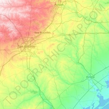
Name: Guadalupe River topographic map, elevation, terrain.
Location: Guadalupe River, United States (28.43026 -99.33089 30.07329 -96.78573)
Average elevation: 522 ft
Minimum elevation: -7 ft
Maximum elevation: 2,218 ft
United States trails, hiking, mountain biking, running and outdoor activities
Other topographic maps
Click on a map to view its topography, its elevation and its terrain.
Baltimore
United States > Maryland > Baltimore
Baltimore is in north-central Maryland on the Patapsco River close to where it empties into the Chesapeake Bay. The city is also located on the fall line between the Piedmont Plateau and the Atlantic coastal plain, which divides Baltimore into "lower city" and "upper city". The city's elevation ranges from sea…
Average elevation: 213 ft
Central Park
United States > New York > New York County > New York
In June 1856, Fernando Wood appointed a "consulting board" of seven people, headed by author Washington Irving, to inspire public confidence in the proposed development. Wood hired military engineer Egbert Ludovicus Viele as the park's chief engineer, tasking him with a topographical survey of the site. The…
Average elevation: 85 ft
San Francisco Bay Area
United States > California > San Francisco
The San Francisco Bay Area is characterized by a diverse and dynamic topography shaped by geological processes over millions of years. This region features a combination of coastal plains, steep hills, and rugged mountains, all influenced by the tectonic activity associated with the nearby San Andreas Fault…
Average elevation: 371 ft
Virginia Beach
United States > Virginia > Virginia Beach
According to the United States Census Bureau, the city has a total area of 497 square miles (1,290 km2), of which 249 square miles (640 km2) is land and 248 square miles (640 km2) (49.9%) is water. It is the largest city in Virginia by total area and third-largest city land area. The average elevation is 12…
Average elevation: 7 ft
Rock Mill
United States > New Jersey > Somerset County > Montgomery Township
Average elevation: 410 ft
Killingworth Court
United States > Connecticut > South Central Connecticut Planning Region > New Haven
Average elevation: 43 ft
Appalachian Mountains
United States > North Carolina > Yancey County
The Appalachian Mountains (French: Appalaches), often called the Appalachians, are a system of mountains in eastern to northeastern North America. The Appalachians first formed roughly 480 million years ago during the Ordovician Period. They once reached elevations similar to those of the Alps and the Rocky…
Average elevation: 4,800 ft
Mauna Kea
United States > Hawaii > Hawaiʻi County
Mauna Kea (/ˌmaʊnə ˈkeɪə/; Hawaiian: [ˈmɐwnə ˈkɛjə]; abbreviation for Mauna a Wākea) is a dormant volcano on the island of Hawaiʻi. Its peak is 4,207.3 m (13,803 ft) above sea level, making it the highest point in the state of Hawaiʻi and second-highest peak of an island on Earth. The peak is…
Average elevation: 13,051 ft
Grand Lake
United States > Colorado > Grand County
Established in 1881, Grand Lake sits at an elevation of 8,369 feet (2,551 m) and derives its name from the lake on whose shores it is situated: Grand Lake, the largest natural body of water in Colorado. The town of Grand Lake was originally an outfitting and supply point for the mining settlements of Lulu…
Average elevation: 8,629 ft
Landisville
United States > Pennsylvania > Bucks County > Buckingham Township
Average elevation: 397 ft
Black Hills
United States > South Dakota > Pennington County
The Black Hills is an isolated mountain range rising from the Great Plains of North America in western South Dakota and extending into Wyoming, United States. Black Elk Peak, which rises to 7,242 feet (2,207 m), is the range's highest summit. The name of the range in Lakota is Pahá Sápa. It encompasses the…
Average elevation: 6,214 ft
Mount Magazine State Park
United States > Arkansas > Logan County
There also exist many opportunities for ATV riding, backpacking, hang gliding, mountain biking, rappelling, and rock climbing within the park. The park hosts the annual Mount Magazine International Butterfly Festival, and is a haven for many rare species of butterflies in Arkansas due to the special blend of…
Average elevation: 1,467 ft
Austrailia Beach
United States > Connecticut > Southeastern Connecticut Planning Region > Mystic
Average elevation: 62 ft
Anna Maria island
United States > Florida > Manatee County
Anna Maria Island features a flat, sandy topography typical of a barrier island on the Gulf Coast. With an average elevation of around 15 feet above sea level, the terrain includes broad beaches, low dunes, and narrow stretches of sandy soil, making it highly vulnerable to storm surges and tidal flooding. The…
Average elevation: 7 ft
Columbus
United States > Ohio > Franklin County > Columbus
The confluence of the Scioto and Olentangy rivers is just north-west of Downtown Columbus. Several smaller tributaries course through the Columbus metropolitan area, including Alum Creek, Big Walnut Creek, and Darby Creek. Columbus is considered to have relatively flat topography thanks to a large glacier that…
Average elevation: 837 ft
El Dorado Hills
United States > California > El Dorado County > Cameron Park
El Dorado Hills (EDH), as defined by the 2010 census-designated place (CDP), is at the western border of El Dorado County, between the City of Folsom and the unincorporated community of Cameron Park. The northern limits of the CDP are Folsom Lake and the South Fork of the American River, where river rafters…
Average elevation: 833 ft
Boise
United States > Idaho > Ada County
Boise (locally /ˈbɔɪsi/ BOY-see) is the capital and most populous city of the U.S. state of Idaho and is the county seat of Ada County. As of the 2020 census, there were 235,684 people residing in the city. On the Boise River in southwestern Idaho, it is 41 miles (66 km) east of the Oregon border and 110…
Average elevation: 3,412 ft
Black Hills
United States > South Dakota > Pennington County
The Black Hills is an isolated mountain range rising from the Great Plains of North America in western South Dakota and extending into Wyoming, United States. Black Elk Peak, which rises to 7,242 feet (2,207 m), is the range's highest summit. The name of the range in Lakota is Pahá Sápa. It encompasses the…
Average elevation: 6,214 ft
Royal Pines Country Club Estates
United States > South Carolina > Beaufort County
Average elevation: 23 ft
Crested Butte
United States > Colorado > Gunnison County
Crested Butte is located in north-central Gunnison County on the west side of the valley of the Slate River, along Coal Creek. Colorado State Highway 135 runs south from Crested Butte 27 miles (43 km) to Gunnison, the county seat. According to the United States Census Bureau, the town of Crested Butte has a…
Average elevation: 9,180 ft
Appalachian Mountains
United States > North Carolina > Yancey County
The Appalachian Mountains (French: Appalaches), often called the Appalachians, are a system of mountains in eastern to northeastern North America. The Appalachians first formed roughly 480 million years ago during the Ordovician Period. They once reached elevations similar to those of the Alps and the Rocky…
Average elevation: 4,800 ft
Estes Park
United States > Colorado > Larimer County
Estes Park sits at an elevation of 7,522 feet (2,293 m) on the front range of the Rocky Mountains at the eastern entrance of the Rocky Mountain National Park. Its north, south and east extremities border the Roosevelt National Forest. Lumpy Ridge lies immediately north of Estes Park.
Average elevation: 8,343 ft
Lakewood
United States > Colorado > Jefferson County > Lakewood
Lakewood is located at 39°42′17″N 105°04′53″W / 39.70472°N 105.08139°W / 39.70472; -105.08139 at an elevation of 5,518 feet (1,682 m). Located at the junction of U.S. Route 6 and Colorado State Highway 121 in central Colorado, the city lies immediately west of Denver and 62 miles (100 km)…
Average elevation: 5,633 ft
Evergreen
United States > Colorado > Jefferson County
Evergreen sits at an elevation of 7,220 feet (2,200 m) in the Rocky Mountains, 19 miles west of Denver, Colorado. Its addresses are oriented according to the Street_system_of_Denver.
Average elevation: 7,575 ft
Jordan Village
United States > Connecticut > Southeastern Connecticut Planning Region > Waterford
Average elevation: 89 ft
Austrailia Beach
United States > Connecticut > Southeastern Connecticut Planning Region > Mystic
Average elevation: 62 ft
Heath Ridge
United States > New York > Westchester County > Village of Scarsdale
Average elevation: 217 ft
Governor Tom McCall Waterfront Park
United States > Oregon > Multnomah County > Portland
Average elevation: 85 ft
Hoover Dam
United States > Arizona > Mohave County
The amount of electricity generated by Hoover Dam has been decreasing along with the falling water level in Lake Mead due to the prolonged drought since year 2000 and high demand for the Colorado River's water. By 2014 its generating capacity was downrated by 23% to 1592 MW and was providing power only during…
Average elevation: 1,407 ft
Scottsdale
United States > Arizona > Maricopa County > Scottsdale
The city is in the Salt River Valley, or the "Valley of the Sun," in the northern reaches of the Sonoran Desert. Scottsdale, 31 mi (50 km) long and 11.4 mi (18.3 km) wide at its widest point, shares boundaries with many other municipalities and entities. On the west, Scottsdale is bordered by Phoenix, Paradise…
Average elevation: 1,358 ft
Highlands
United States > North Carolina > Macon County > Highlands
Highlands was founded in 1875 after its two founders, Samuel Truman Kelsey and Clinton Carter Hutchinson, drew lines from Chicago to Savannah and from New Orleans to New York City. They felt that the place where these lines met would eventually become a great trading center and commercial crossroads. Highlands…
Average elevation: 3,576 ft
Mount Rushmore
United States > South Dakota > Pennington County
Mount Rushmore National Memorial is centered on a colossal sculpture carved into the granite face of Mount Rushmore (Lakota: Tȟuŋkášila Šákpe, or Six Grandfathers) in the Black Hills near Keystone, South Dakota. Sculptor Gutzon Borglum created the sculpture's design and oversaw the project's execution…
Average elevation: 5,125 ft
Georgetown
United States > Texas > Georgetown
The city is located on the northeastern edge of Texas Hill Country. Portions of Georgetown are located on either side of the Balcones Escarpment, a fault line in which the areas roughly east of IH-35 are flat and characterized by having black, fertile soils of the Blackland Prairie, and the west side of the…
Average elevation: 719 ft
Port Charlotte
United States > Florida > Charlotte County
Port Charlotte is characterized by a predominantly flat and low-lying terrain, typical of Florida’s coastal landscape. The area features a network of waterways, including the Peace River and Charlotte Harbor, which provide ample opportunities for recreational activities like boating and fishing. Elevations…
Average elevation: 13 ft
Florida Keys
United States > Florida > Monroe County
Tropical cyclones present special dangers and challenges to the entire Keys. Because no area of the islands is more than 20 feet (6.1 m) above sea level (and many are only a few feet elevation), and water surrounds the islands, nearly every neighborhood is subject to flooding as well as hurricane winds. In…
Average elevation: 0 ft
Winnipesaukee
United States > New Hampshire > Carroll County > Moultonborough
Average elevation: 528 ft
Cranberry Lake
United States > Michigan > Oakland County > White Lake Charter Township
Average elevation: 968 ft
Wrightstown
United States > Pennsylvania > Bucks County > Wrightstown Township
Average elevation: 279 ft
Indian Head Lake Estates
United States > Arkansas > Pulaski County > Sherwood
Average elevation: 259 ft
Uinta Mountains
The high Uintas were extensively glaciated during the last ice age, and most of the large stream valleys on both the north and south sides of the range held long valley glaciers. However, despite reaching to over 13,500 feet (4,110 m) in elevation, the climate today is sufficiently dry that no glaciers…
Average elevation: 7,753 ft
Golden Gate Park
United States > California > San Francisco
In the 1860s, San Franciscans began to feel the need for a spacious public park similar to Central Park, which was then taking shape in New York City. Golden Gate Park was carved out of unpromising sand and shore dunes that were known as the Outside Lands, in an unincorporated area west of San Francisco's…
Average elevation: 233 ft
Mount Washington
United States > New Hampshire > Coos County
Mount Washington, also known as Agiocochook, is an ultra-prominent mountain in the state of New Hampshire. It is the highest peak in the Northeastern United States at 6,288.2 ft (1,916.6 m) and the most topographically prominent mountain east of the Mississippi River.
Average elevation: 5,144 ft
Denali
United States > Alaska > Denali Borough
Denali (/dəˈnɑːli/), federally designated as Mount McKinley, is the highest mountain peak in North America, with a summit elevation of 20,310 feet (6,190 m) above sea level. It is the tallest mountain in the world from base to peak on land, measuring 18,000 ft (5,500 m). With a topographic prominence of…
Average elevation: 18,196 ft
Stone Mountain
United States > Georgia > DeKalb County
The park is owned by the state of Georgia and is currently managed by Herschend Family Entertainment. At its summit, the elevation is 1,686 feet (514 m) above sea level and 825 feet (251 m) above the surrounding area. Stone Mountain is well known for not only its geology, but also the enormous rock relief on…
Average elevation: 981 ft
Fairplay
United States > Colorado > Park County
The historic Town of Fairplay is the Statutory Town that is the county seat and the most populous municipality of Park County, Colorado, United States. The town population was 724 at the 2020 United States Census. Fairplay is located in South Park at an elevation of 9,953 feet (3,034 m). The town is the…
Average elevation: 9,990 ft