
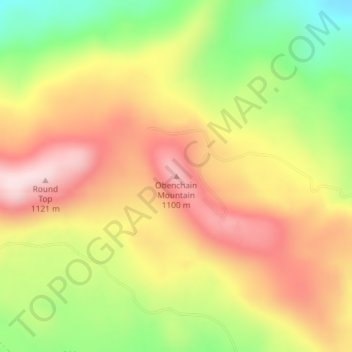
Obenchain Mountain topographic map
Interactive map
Click on the map to display elevation.
About this map
Name: Obenchain Mountain topographic map, elevation, terrain.
Location: Obenchain Mountain, Jackson County, Oregon, United States (42.54091 -122.67120 42.54101 -122.67110)
Average elevation: 3,064 ft
Minimum elevation: 2,369 ft
Maximum elevation: 3,661 ft
Oregon trails, hiking, mountain biking, running and outdoor activities
Other topographic maps
Click on a map to view its topography, its elevation and its terrain.
Newberg
United States > Oregon > Yamhill County
According to the United States Census Bureau, the city has a total area of 5.81 square miles (15.05 km2), all of it land. It averages 176 feet (54 m) in elevation.
Average elevation: 200 ft
Willamette River
United States > Oregon > Polk County
The Willamette River drains a region of 11,478 square miles (29,730 km2), which is 12 percent of the total area of Oregon. Bounded by the Coast Range to the west and the Cascade Range to the east, the river basin is about 180 miles (290 km) long and 100 miles (160 km) wide. Elevations within the watershed…
Average elevation: 236 ft
Duck Lake Willamette River Greenway
United States > Oregon > Multnomah County > Scappoose
Average elevation: 171 ft
Cave Junction
United States > Oregon > Josephine County
Cave Junction is located on U.S. Route 199 at its junction with Oregon Route 46. It is about 30 miles or 48 kilometres southwest of Grants Pass, Oregon and 53 miles or 85 kilometres northeast of Crescent City, California. The city lies in the Illinois Valley, on the northwest slope of the Siskiyou Range, at an…
Average elevation: 1,345 ft
Suttle Lake
United States > Oregon > Jefferson County
Suttle Lake is located near the crest of the Cascade Mountains in western Jefferson County, Oregon. Its elevation is 3,438 feet (1,048 m) above sea level. The lake is surrounded by the Deschutes National Forest. The lake is 13 miles (21 km) west of Sisters, Oregon and 90 miles (140 km) east of Salem, in the…
Average elevation: 3,671 ft
Lake of the Woods
United States > Oregon > Klamath County
Lake of the Woods is located near the crest of the Cascade Mountains in western Klamath County, Oregon. Its elevation is 4,949 feet (1,508 m) above sea level. The lake is surrounded by the Fremont–Winema National Forest. Lake of the Woods is 33 miles (53 km) west of Klamath Falls and 43 miles (69 km) east of…
Average elevation: 5,210 ft
McKenzie River
United States > Oregon > Lane County > Rainbow
The McKenzie River drains a region of about 1,300 square miles (3,400 km2) and is one of the primary tributaries of the Willamette River. Elevations in the watershed range from 10,358 feet (3,157 m) at the summit of the South Sister to 375 feet (114 m) at the McKenzie's mouth on the Willamette River north of…
Average elevation: 1,414 ft
Elkton
United States > Oregon > Douglas County
According to the United States Census Bureau, the city has a total area of 0.26 square miles (0.67 km2), of which, 0.23 square miles (0.60 km2) is land and 0.03 square miles (0.08 km2) is water. The elevation is 141 feet (43 m).
Average elevation: 312 ft
John Day
United States > Oregon > Grant County
John Day is at an elevation of 3,087 feet (941 m). According to the United States Census Bureau, the city has a total area of 1.87 square miles (4.84 km2), all land.
Average elevation: 3,435 ft
Archie Briggs Canyon Natural Area
United States > Oregon > Deschutes County > Bend
Average elevation: 3,658 ft
Cascade Locks Marine Park
United States > Oregon > Hood River County > Cascade Locks
Average elevation: 236 ft
Central Point
United States > Oregon > Jackson County
The city lies at an elevation of about 1,272 feet (388 m) along Oregon Highway 99 and Interstate 5 northwest of Medford. Jacksonville is to the south and Gold Hill to the northwest. The Central Oregon and Pacific Railroad passes through Central Point.
Average elevation: 1,263 ft
Waldo Lake Wilderness
United States > Oregon > Lane County
Ninety-eight percent of the Waldo Lake Wilderness is covered by forest on moderate to steep terrain, which ranges in elevation from 2,800 to 7,144 feet (853 to 2,177 m).
Average elevation: 5,013 ft
Forest Park
United States > Oregon > Multnomah County > Portland
Solidified lava from Grande Ronde members of the Columbia River Basalt Group underlie Forest Park. About 16 million years ago during the Middle Miocene, the Columbia River ran through a lowland south of its modern channel. Eruptions from linear vents in eastern Oregon and Washington flowed down this channel…
Average elevation: 299 ft