
Cibitoke topographic map
Interactive map
Click on the map to display elevation.
About this map
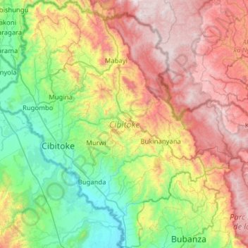
Name: Cibitoke topographic map, elevation, terrain.
Location: Cibitoke, Burundi (-3.10400 29.00072 -2.59109 29.48584)
Average elevation: 5,003 ft
Minimum elevation: 2,598 ft
Maximum elevation: 8,816 ft
Other topographic maps
Click on a map to view its topography, its elevation and its terrain.
Buterere
Burundi > Bujumbura Mairie > Buterere
Buterere, Bujumbura Mairie, 331, Burundi
Average elevation: 2,589 ft