
Churubamba topographic map
Click on the map to display elevation.
About this map
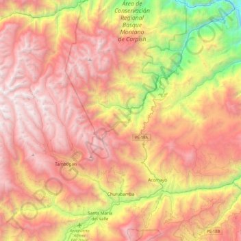
Name: Churubamba topographic map, elevation, terrain.
Location: Churubamba, Huánuco, Perú (-9.88896 -76.47757 -9.51242 -76.06088)
Average elevation: 8,891 ft
Minimum elevation: 2,487 ft
Maximum elevation: 14,085 ft
Other topographic maps
Click on a map to view its topography, its elevation and its terrain.
San Jose De Huampani
Perú > Huánuco > San Pablo de Pillao > San Jose De Huampani
Average elevation: 8,921 ft
Santa Rosa de Alto Yanajanca
Perú > Huánuco > Santa Rosa de Alto Yanajanca > Santa Rosa de Alto Yanajanca
Average elevation: 1,831 ft
San Ramon de Macha
Perú > Huánuco > San Francisco de Cayrán > San Ramon de Macha
Average elevation: 10,348 ft
Santa Cruz de Ratacocha
Perú > Huánuco > Santa María del Valle > San Pablo De Pichuy
Average elevation: 9,396 ft
Tomayquichua
Perú > Huánuco > Tomay Kichwa
Tomayquichua es una localidad de Perú. Es capital del distrito de Tomay Kichwa en la provincia de Ambo, departamento de Huánuco. Se encuentra a aproximadamente 19 kilómetros de la ciudad de Huánuco y a 4,5 km de Ambo. Está a una altitud de 2041 m s. n. m.
Average elevation: 7,530 ft