
Bath County topographic map
Interactive map
Click on the map to display elevation.
About this map
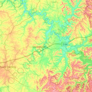
Name: Bath County topographic map, elevation, terrain.
Location: Bath County, Kentucky, United States (37.99268 -83.97798 38.30269 -83.46305)
Average elevation: 889 ft
Minimum elevation: 607 ft
Maximum elevation: 1,391 ft
Kentucky trails, hiking, mountain biking, running and outdoor activities
Other topographic maps
Click on a map to view its topography, its elevation and its terrain.
Jefferson Memorial Forest
United States > Kentucky > Jefferson County > Louisville
Average elevation: 538 ft
Pine Mountain State Resort Park
United States > Kentucky > Bell County > Pineville
Average elevation: 1,604 ft