
Pendleton County topographic map
Interactive map
Click on the map to display elevation.
About this map
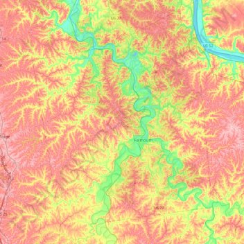
Name: Pendleton County topographic map, elevation, terrain.
Location: Pendleton County, Kentucky, United States (38.52944 -84.53177 38.87470 -84.19535)
Average elevation: 758 ft
Minimum elevation: 472 ft
Maximum elevation: 991 ft
Kentucky trails, hiking, mountain biking, running and outdoor activities
Other topographic maps
Click on a map to view its topography, its elevation and its terrain.
Jefferson Memorial Forest
United States > Kentucky > Jefferson County > Louisville
Average elevation: 538 ft
Black Mountain
United States > Kentucky > Harlan County
Black Mountain is the highest mountain peak in the Commonwealth of Kentucky, United States, with a summit elevation of 4,145 feet (1,263 m) above mean sea level and a top-to-bottom height of over 2,500 feet (760 m). The summit is located at approximately 36°54′51″N 82°53′38″W / 36.91417°N…
Average elevation: 3,635 ft
Pine Mountain State Resort Park
United States > Kentucky > Bell County > Pineville
Average elevation: 1,604 ft