Geolocate
Thank you for supporting this site ❤️
Make a donation

Callahan County topographic map

Interactive map

Click on the map to display elevation.

Callahan County

Callahan Divide is range of hills that extends 26 miles (42 km) from west to southeast through Taylor and Callahan Counties, with highest elevation 2,411 ft (735 m), which together with other elevated areas in the two counties provide advantages in wind energy.

Wikipedia (CC-BY-SA 3.0)

About this map

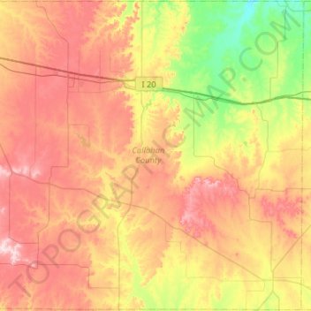
Name: Callahan County topographic map, elevation, terrain.

Location: Callahan County, Texas, United States (32.07962 -99.63236 32.51511 -99.11430)

Average elevation: 1,801 ft

Minimum elevation: 1,355 ft

Maximum elevation: 2,297 ft

Texas trails, hiking, mountain biking, running and outdoor activities

Other topographic maps

Click on a map to view its topography, its elevation and its terrain.

Canyon Lake

United States > Texas > Comal County

Average elevation: 971 ft

Dallas

United States > Texas > Dallas County

Dallas and its surrounding area are mostly flat. The city lies at elevations ranging from 450 to 550 feet (137 to 168 m) above sea level. The western edge of the Austin Chalk Formation, a limestone escarpment (also known as the "White Rock Escarpment"), rises 230 feet (70 m) and runs roughly north–south…

Average elevation: 518 ft

Kingwood

United States > Texas > Harris County > Houston

Average elevation: 72 ft

Terlingua

United States > Texas > Brewster County

Average elevation: 2,861 ft

San Antonio

United States > Texas > Bexar County > San Antonio

Average elevation: 715 ft

Bryan

United States > Texas > Brazos County > Bryan

Average elevation: 292 ft

Center Point

United States > Texas > Parker County

Average elevation: 961 ft

Nurse

United States > Texas > Erath County > Stephenville

Average elevation: 1,329 ft

Doucette

United States > Texas > Tyler County

Average elevation: 315 ft

Spring

United States > Texas > Harris County

Average elevation: 115 ft

Shannon

United States > Texas > Clay County

Average elevation: 1,053 ft

Naruna

United States > Texas > Burnet County

Average elevation: 1,460 ft

New Salem

United States > Texas > Palo Pinto County

Average elevation: 863 ft

Emory Peak

United States > Texas > Brewster County

The peak can be reached by a moderate hike on a well-marked path across steep rocky terrain with an elevation gain of approximately 2,500 feet (760 m). The Emory Peak Trail is about 1.5 miles (2.4 km) long. The trail is reached by climbing the Pinnacles Trail 3.5 miles (5.6 km) from the Chisos Basin trailhead.…

Average elevation: 6,762 ft

Las Palmas

United States > Texas > Zapata County

Average elevation: 453 ft

Palmview

United States > Texas > Hidalgo County

Average elevation: 141 ft

Blossom

United States > Texas > Lamar County

Average elevation: 545 ft

New Braunfels

United States > Texas > Comal County

Average elevation: 748 ft

Desdemona

United States > Texas > Eastland County

Average elevation: 1,385 ft

Call

United States > Texas > Newton County

Average elevation: 105 ft

Kenney

United States > Texas > Austin County

Average elevation: 335 ft

Columbus

United States > Texas > Colorado County

Average elevation: 200 ft

Jacksonville

United States > Texas > Cherokee County

Average elevation: 499 ft

Weatherford

United States > Texas > Parker County

Average elevation: 1,070 ft

Brazos

United States > Texas > Palo Pinto County

Average elevation: 837 ft

Sewell Park

United States > Texas > Hays County > San Marcos

Average elevation: 630 ft

Lockhart State Park

United States > Texas > Caldwell County > Lockhart

The park features roughly four miles of designated trails that cover a wide range of environments. In addition to multiple short, shade covered trails along the creek in a riparian zone, a network of natural trails traversing multiple hillsides and ravines is located on the backside of the park. A moderate…

Average elevation: 541 ft

Singleton

United States > Texas > Grimes County

Average elevation: 341 ft

Cranes Mill

United States > Texas > Comal County

Average elevation: 1,010 ft

Cresson

United States > Texas > Hood County

Average elevation: 994 ft

Happy Valley

United States > Texas > Nacogdoches County

Average elevation: 371 ft

Guadalupe Peak

United States > Texas > Culberson County

Guadalupe Peak, also known as Signal Peak, is the highest natural point in Texas, with an elevation of 8,751 feet (2,667 m) above sea level. It is located in Guadalupe Mountains National Park, and is part of the Guadalupe Mountains range in southeastern New Mexico and West Texas. The mountain is about 90 miles…

Average elevation: 7,054 ft

Pecan Grove

United States > Texas > Fort Bend County

Average elevation: 89 ft

Theon

United States > Texas > Williamson County

Average elevation: 840 ft

Terrell

United States > Texas > Kaufman County

Average elevation: 502 ft

Pinehurst

United States > Texas > Montgomery County

Average elevation: 220 ft

Bassett

United States > Texas > Bowie County

Average elevation: 262 ft

Boomtown

United States > Texas > Tarrant County > Arlington

Average elevation: 558 ft

Concepcion Park

United States > Texas > Bexar County > San Antonio

Average elevation: 620 ft

Port O'Connor

United States > Texas > Calhoun County

Average elevation: 10 ft

New Caney

United States > Texas > Montgomery County

Average elevation: 98 ft

Moonshine Hill

United States > Texas > Harris County > Houston

Average elevation: 72 ft

Joppa

United States > Texas > Burnet County

Average elevation: 1,122 ft

Spring Branch

United States > Texas > Comal County

Average elevation: 1,142 ft

Smith

United States > Texas > Bell County > Temple

Average elevation: 630 ft

Menard Park

United States > Texas > Galveston County > Galveston

Average elevation: 13 ft

Hagansport

United States > Texas > Franklin County

Average elevation: 371 ft

Purdue Lake Dam

United States > Texas > Fannin County

Average elevation: 663 ft

Eddy

United States > Texas > McLennan County > Bruceville-Eddy

Average elevation: 692 ft

Tripp

United States > Texas > Dallas County > Sunnyvale

Average elevation: 469 ft

Catarina

United States > Texas > Dimmit County

Average elevation: 515 ft

Clear Lake City

United States > Texas > Harris County > Houston

Average elevation: 26 ft

Indian Creek

United States > Texas > Fannin County > Trenton

Average elevation: 755 ft

Sandusky

United States > Texas > Grayson County

Average elevation: 722 ft

Vanderpool

United States > Texas > Bandera County

Average elevation: 1,719 ft

Bulverde

United States > Texas > Comal County

Average elevation: 1,194 ft

Godley

United States > Texas > Johnson County

Average elevation: 942 ft

Buckner

United States > Texas > Collin County > McKinney

Average elevation: 646 ft

Tracy

United States > Texas > Milam County

Average elevation: 427 ft

Blanco State Park

United States > Texas > Blanco County > Blanco

Average elevation: 1,368 ft

Kemper City

United States > Texas > Victoria County

Average elevation: 98 ft

The Cove

United States > Texas > Tarrant County > Grand Prairie

Average elevation: 538 ft

Cornudas

United States > Texas > Hudspeth County

Average elevation: 4,334 ft

Shepard Hill

United States > Texas > Montgomery County

Average elevation: 282 ft

Alamo Beach

United States > Texas > Calhoun County

Average elevation: 7 ft

Bentsen Colonia

United States > Texas > Hidalgo County > McAllen

Average elevation: 125 ft

Graham

United States > Texas > Young County

Average elevation: 1,089 ft

Doc Brown

United States > Texas > Orange County > West Orange

Average elevation: 16 ft

Chimney Rock Park

United States > Texas > Harris County > Houston

Average elevation: 69 ft

Blessing

United States > Texas > Matagorda County

Average elevation: 43 ft

Dicey

United States > Texas > Parker County

Average elevation: 971 ft

Fosters Mill

United States > Texas > Harris County > Houston

Average elevation: 69 ft

Calvary

United States > Texas > Wood County

Average elevation: 433 ft

Flower Mountain

United States > Texas > Nacogdoches County

Average elevation: 600 ft

Agua Dulce

United States > Texas > El Paso County

Average elevation: 4,019 ft

Marfa

United States > Texas > Presidio County

Marfa is a city in the high desert of the Trans-Pecos in far West Texas, United States, between the Davis Mountains and Big Bend National Park, at an elevation of 4685 feet. It is the county seat of Presidio County, and its population as of the 2020 United States Census was 1,788. The city was founded in the…

Average elevation: 4,705 ft

Austin

United States > Texas > Travis County

The elevation of Austin varies from 425 feet (130 m) to approximately 1,000 feet (305 m) above sea level. Due to the fact it straddles the Balcones Fault, much of the eastern part of the city is flat, with heavy clay and loam soils, whereas the western part and western suburbs consist of rolling hills on the…

Average elevation: 666 ft

Tavener

United States > Texas > Fort Bend County

Average elevation: 118 ft

Boz

United States > Texas > Ellis County

Average elevation: 636 ft

Klein

United States > Texas > Harris County

Average elevation: 141 ft

Caplen

United States > Texas > Galveston County

Average elevation: 3 ft

Penwell

United States > Texas > Ector County

Average elevation: 2,949 ft

Heights

United States > Texas > Galveston County > Texas City

Average elevation: 16 ft

Segovia

United States > Texas > Kimble County

Average elevation: 1,880 ft

Renner

United States > Texas > Collin County > Dallas

Average elevation: 676 ft

Junction

United States > Texas > Kimble County

Average elevation: 1,745 ft

Townewest

United States > Texas > Fort Bend County

Average elevation: 92 ft

McMahan

United States > Texas > Caldwell County

Average elevation: 482 ft

Enchanted Rock

United States > Texas > Llano County

Enchanted Rock is a pink granite mountain located in the Llano Uplift about 17 miles (27 km) north of Fredericksburg, Texas and 24 miles (39 km) south of Llano, Texas, United States. Enchanted Rock State Natural Area, which includes Enchanted Rock and surrounding land, spans the border between Gillespie and…

Average elevation: 1,486 ft