Geolocate

Kenton County topographic map

Interactive map

Click on the map to display elevation.

Kenton County

According to the United States Census Bureau, the county has a total area of 164 square miles (420 km2), of which 160 square miles (410 km2) is land and 4.1 square miles (11 km2) (2.5%) is water. The county is located at the confluence of the Licking River and Ohio River, in the outer Bluegrass area of the Bluegrass region of the state. The elevation in the county ranges from 455 feet (139 m) to 960 feet (293 m) above sea level.

Wikipedia (CC-BY-SA 3.0)

About this map

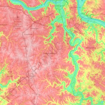
Name: Kenton County topographic map, elevation, terrain.

Location: Kenton County, Kentucky, United States (38.78969 -84.62370 39.09992 -84.41749)

Average elevation: 764 ft

Minimum elevation: 443 ft

Maximum elevation: 961 ft

Kentucky trails, hiking, mountain biking, running and outdoor activities

Other topographic maps

Click on a map to view its topography, its elevation and its terrain.

Lexington

United States > Kentucky > Lexington

Average elevation: 935 ft

Nancy

United States > Kentucky > Pulaski County

Average elevation: 1,024 ft

Ritner

United States > Kentucky > Wayne County

Average elevation: 1,007 ft

Parnell

United States > Kentucky > Wayne County

Average elevation: 951 ft

Jabez

United States > Kentucky > Russell County

Average elevation: 935 ft

Index

United States > Kentucky > Morgan County > West Liberty

Average elevation: 922 ft

Cundiff

United States > Kentucky > Adair County

Average elevation: 830 ft

Salvisa

United States > Kentucky > Mercer County

Average elevation: 814 ft

Black Mountain

United States > Kentucky > Harlan County

Black Mountain is the highest mountain peak in the Commonwealth of Kentucky, United States, with a summit elevation of 4,145 feet (1,263 m) above mean sea level and a top-to-bottom height of over 2,500 feet (760 m). The summit is located at approximately 36°54′51″N 82°53′38″W / 36.91417°N…

Average elevation: 3,635 ft

Pitts Point

United States > Kentucky > Bullitt County

Average elevation: 509 ft

Delta

United States > Kentucky > Wayne County

Average elevation: 1,020 ft

Millville

United States > Kentucky > Woodford County

Average elevation: 774 ft

Defeated Creek

United States > Kentucky > Letcher County

Average elevation: 1,614 ft

Witt Springs

United States > Kentucky > Estill County

Average elevation: 751 ft

Canoe

United States > Kentucky > Breathitt County

Average elevation: 981 ft

Jason

United States > Kentucky > Todd County

Average elevation: 666 ft

Varney

United States > Kentucky > Pike County

Average elevation: 1,234 ft

Barren River

United States > Kentucky > Warren County

Average elevation: 577 ft

Rosine

United States > Kentucky > Ohio County

Average elevation: 591 ft

Zion

United States > Kentucky > Henderson County

Average elevation: 427 ft

Big South Fork

United States > Kentucky > Marion County

Average elevation: 781 ft

Lockport

United States > Kentucky > Henry County

Average elevation: 656 ft

Double Small Arches

United States > Kentucky > Laurel County

Average elevation: 1,138 ft

Glens Fork

United States > Kentucky > Adair County

Average elevation: 876 ft

Richelieu

United States > Kentucky > Butler County

Average elevation: 607 ft

Briensburg

United States > Kentucky > Marshall County

Average elevation: 466 ft

Artemus

United States > Kentucky > Knox County

Average elevation: 1,132 ft

Rousseau

United States > Kentucky > Breathitt County

Average elevation: 1,014 ft

Annville

United States > Kentucky > Jackson County

Average elevation: 1,178 ft

Shiloh

United States > Kentucky > Calloway County

Average elevation: 499 ft

Creekville

United States > Kentucky > Leslie County

Average elevation: 1,227 ft

Highway

United States > Kentucky > Clinton County

Average elevation: 942 ft

Bonnyman

United States > Kentucky > Perry County

Average elevation: 1,181 ft

Bosco

United States > Kentucky > Floyd County

Average elevation: 932 ft

Creekmur Hill

United States > Kentucky > Hopkins County

Average elevation: 456 ft

Highland

United States > Kentucky > Lincoln County

Average elevation: 1,296 ft

Elmburg

United States > Kentucky > Shelby County

Average elevation: 833 ft

Big Fork

United States > Kentucky > Leslie County

Average elevation: 1,749 ft

Tollesboro

United States > Kentucky > Lewis County

Average elevation: 784 ft

Cordell

United States > Kentucky > Lawrence County

Average elevation: 906 ft

Shakertown

United States > Kentucky > Mercer County

Average elevation: 827 ft

Southville

United States > Kentucky > Shelby County

Average elevation: 758 ft

Francisville

United States > Kentucky > Boone County

Average elevation: 751 ft

Straw

United States > Kentucky > Edmonson County

Average elevation: 738 ft

Bradley

United States > Kentucky > Magoffin County

Average elevation: 1,073 ft

Buzzard Roost

United States > Kentucky > Calloway County

Average elevation: 459 ft

Ezel

United States > Kentucky > Morgan County

Average elevation: 958 ft

Sullivan

United States > Kentucky > Union County

Average elevation: 387 ft

Knoxville

United States > Kentucky > Pendleton County

Average elevation: 823 ft

Van Cleave

United States > Kentucky > Calloway County

Average elevation: 528 ft

Gilbertsville

United States > Kentucky > Marshall County

Average elevation: 341 ft

Vealsburg

United States > Kentucky > Graves County

Average elevation: 528 ft

Cumberland Falls

United States > Kentucky > McCreary County

Average elevation: 1,024 ft

Hargis

United States > Kentucky > Pulaski County

Average elevation: 928 ft

Timsley

United States > Kentucky > Bell County

Average elevation: 1,358 ft

Alberta

United States > Kentucky > Scott County

Average elevation: 912 ft

Walker

United States > Kentucky > Knox County

Average elevation: 1,322 ft

Little Pilot Knob

United States > Kentucky > Wayne County

Average elevation: 1,227 ft

Balltown

United States > Kentucky > Whitley County > Williamsburg

Average elevation: 1,089 ft

Rineyville

United States > Kentucky > Hardin County

Average elevation: 797 ft

Pine Mountain

United States > Kentucky > Harlan County

Average elevation: 1,759 ft

Paint Lick

United States > Kentucky > Garrard County

Average elevation: 892 ft

Glendale

United States > Kentucky > Hardin County

Average elevation: 696 ft

Lenarue

United States > Kentucky > Harlan County

Average elevation: 1,703 ft

Sparrow

United States > Kentucky > Anderson County

Average elevation: 755 ft

Load

United States > Kentucky > Greenup County

Average elevation: 728 ft

Cawood

United States > Kentucky > Harlan County

Average elevation: 1,634 ft

Frost

United States > Kentucky > Greenup County

Average elevation: 591 ft

Lone Star

United States > Kentucky > Hart County

Average elevation: 748 ft

Pathfork

United States > Kentucky > Harlan County

Average elevation: 1,752 ft

Canmer

United States > Kentucky > Hart County

Average elevation: 607 ft

Boyd

United States > Kentucky > Harrison County

Average elevation: 702 ft

Holmes Mill

United States > Kentucky > Harlan County

Average elevation: 2,487 ft

Big Laurel

United States > Kentucky > Harlan County

Average elevation: 1,883 ft

Bardo

United States > Kentucky > Harlan County

Average elevation: 2,080 ft

Hardyville

United States > Kentucky > Hart County

Average elevation: 696 ft

Leesburg

United States > Kentucky > Harrison County

Average elevation: 919 ft

Uno

United States > Kentucky > Hart County

Average elevation: 659 ft

Pansy

United States > Kentucky > Harlan County

Average elevation: 1,975 ft

Walnut Hill

United States > Kentucky > Fayette County > Lexington

Average elevation: 1,020 ft

Jonesville

United States > Kentucky > Hart County

Average elevation: 791 ft

Broadwell

United States > Kentucky > Harrison County

Average elevation: 866 ft

Saint John

United States > Kentucky > Hardin County

Average elevation: 778 ft

Nolin

United States > Kentucky > Hardin County

Average elevation: 689 ft

Wolf

United States > Kentucky > Carter County

Average elevation: 889 ft

Limp

United States > Kentucky > Hardin County

Average elevation: 692 ft

Ages

United States > Kentucky > Harlan County

Average elevation: 1,926 ft

Kenvir

United States > Kentucky > Harlan County

Average elevation: 2,106 ft

Yancey

United States > Kentucky > Harlan County

Average elevation: 2,136 ft

Putney

United States > Kentucky > Harlan County

Average elevation: 1,972 ft

Lejunior

United States > Kentucky > Harlan County

Average elevation: 1,919 ft

Alva

United States > Kentucky > Harlan County

Average elevation: 2,139 ft

Fresh Meadows

United States > Kentucky > Harlan County

Average elevation: 1,516 ft

Molus

United States > Kentucky > Harlan County

Average elevation: 1,532 ft