
Ireland topographic map
Click on the map to display elevation.
Ireland
Ireland's topography is characterized by a central limestone plain, averaging about 75 meters (246 feet) above sea level, interspersed with numerous lakes, bogs, and low ridges. This plain is encircled by coastal mountains of varying geological compositions. In the southwest, the MacGillycuddy's Reeks, composed of old red sandstone, include Carrauntoohil, Ireland's highest peak at 1,038 meters (3,406 feet). The Wicklow Mountains to the east are primarily granite formations, with Lugnaquilla reaching 925 meters (3,035 feet). The north features the basaltic Antrim Plateau and the rugged quartzite peaks of the Donegal Mountains. The coastline is notably rugged and heavily indented along the south and west, where mountain ranges terminate in bold headlands and rocky islands, forming long, narrow fjord-like inlets and wide-mouthed bays. In contrast, the east coast is more uniform, with fewer natural harbors. The River Shannon, Ireland's longest river at approximately 370 kilometers (230 miles), flows south from County Cavan, draining the central plain before emptying into the Atlantic Ocean through a nearly 110-kilometer-long (68 miles) estuary.
About this map
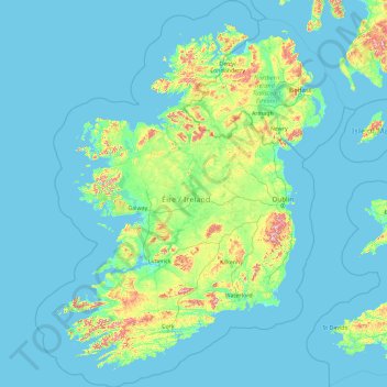
Name: Ireland topographic map, elevation, terrain.
Location: Ireland (51.22200 -11.01338 55.63600 -5.65824)
Average elevation: 144 ft
Minimum elevation: -10 ft
Maximum elevation: 2,694 ft
Other topographic maps
Click on a map to view its topography, its elevation and its terrain.
San Francisco Bay Area
United States > California > San Francisco
The San Francisco Bay Area is characterized by a diverse and dynamic topography shaped by geological processes over millions of years. This region features a combination of coastal plains, steep hills, and rugged mountains, all influenced by the tectonic activity associated with the nearby San Andreas Fault…
Average elevation: 371 ft
Broad Peak
China > Xinjiang > Taxkorgan Tajik Autonomous County > Dafdar
Broad Peak is one of the eight-thousanders, and is located in the Karakoram range spanning Gilgit-Baltistan, Pakistan and Xinjiang, China. It is the 12th highest mountain in the world at 8,051 metres (26,414 ft) elevation above sea level. The first ascent of this mountain was in June 1957, accomplished by…
Average elevation: 23,350 ft
Europe
Europe's topography is characterized by a striking contrast between its rugged southern mountains and the expansive plains of the north. The continent is often described as a "peninsula of peninsulas," featuring major peninsulas like the Iberian, Italian, and Balkan, each with unique geological features. In…
Average elevation: 732 ft
City of London
United Kingdom > England > City of London > City of London
The elevation of the City ranges from sea level at the Thames to 21.6 metres (71 ft) at the junction of High Holborn and Chancery Lane. Two small but notable hills are within the historic core, Ludgate Hill to the west and Cornhill to the east. Between them ran the Walbrook, one of the many "lost" rivers or…
Average elevation: 138 ft
Flagstaff
United States > Arizona > Coconino County
Flagstaff, located in Coconino County, Arizona, is characterized by its diverse topography, primarily shaped by its high elevation and volcanic activity. Sitting at around 7,000 feet (approximately 2,130 meters), the city is surrounded by the expansive Coconino National Forest, which features a blend of…
Average elevation: 7,139 ft
Palm Harbor
United States > Florida > Pinellas County
Palm Harbor is characterized by its unique topography, which features a relatively rare hilly landscape for the region. Unlike much of the surrounding areas in Pinellas County, which are predominantly flat, Palm Harbor includes elevations that can reach up to about 75 feet above sea level. This elevation gives…
Average elevation: 30 ft
Pinetop-Lakeside
United States > Arizona > Navajo County
Pinetop-Lakeside is nestled in the stunning White Mountains of northeastern Arizona, characterized by a varied topography that significantly influences its natural beauty and recreational opportunities. The terrain features elevations averaging around 6,795 feet, with rugged mountain landscapes interspersed…
Average elevation: 6,847 ft
Baltimore
Baltimore exhibits a diverse topography that plays a significant role in its character and development. Situated along the Patapsco River, which flows into the Chesapeake Bay, the city is positioned on the fall line that separates the Piedmont Plateau to the west from the Atlantic Coastal Plain to the east.…
Average elevation: 213 ft
Atlanta
United States > Georgia > Fulton County
Atlanta occupies a high, rolling part of the Georgia Piedmont, a physiographic region described as a landscape of low hills and narrow valleys between the Blue Ridge Mountains and the Upper Coastal Plain. Around downtown and Fulton County, the terrain is gently dissected rather than flat, with broad urban…
Average elevation: 935 ft
North America
North America's topography is characterized by its diverse and dramatic landscapes, stretching from the towering Rocky Mountains in the west to the expansive Great Plains in the central region, and the rugged Appalachian Mountains in the east. The Rocky Mountains, which include peaks exceeding 20,000 feet…
Average elevation: 965 ft
Indianapolis
United States > Indiana > Indianapolis
Indianapolis is within the Tipton Till Plain, a flat to gently sloping terrain underlain by glacial deposits known as till. The lowest point in the city is about 650 feet (198 m) above mean sea level, with the highest natural elevation at about 900 feet (274 m) above sea level. Few hills or short ridges, known…
Average elevation: 791 ft
Utica
United States of America > New York > Utica
The city's Mohawk name, Unundadages ("around the hill") refers to a bend in the Mohawk River that flows around the city's elevated position as seen from the Deerfield Hills in the north. The Erie Canal and Mohawk River pass through northern Utica; northwest of downtown is the Utica Marsh, a group of cattail…
Average elevation: 879 ft
McKinleyville
United States > California > Humboldt County
McKinleyville (formerly Minorsville) is a census-designated place (CDP) in Humboldt County, California McKinleyville is located 5.25 miles (8.4 km) north of Arcata, at an elevation of 141 feet (43 m). The population was 15,177 at the 2010 census, up from 13,599 at the time of the 2000 census.
Average elevation: 161 ft
Evergreen
United States > Colorado > Jefferson County
Evergreen sits at an elevation of 7,220 feet (2,200 m) in the Rocky Mountains, 19 miles west of Denver, Colorado. Its addresses are oriented according to the Street_system_of_Denver.
Average elevation: 7,575 ft
El Dorado Hills
United States > California > El Dorado County > Cameron Park
El Dorado Hills (EDH), as defined by the 2010 census-designated place (CDP), is at the western border of El Dorado County, between the City of Folsom and the unincorporated community of Cameron Park. The northern limits of the CDP are Folsom Lake and the South Fork of the American River, where river rafters…
Average elevation: 833 ft
Port Charlotte
United States > Florida > Charlotte County
Port Charlotte is characterized by a predominantly flat and low-lying terrain, typical of Florida’s coastal landscape. The area features a network of waterways, including the Peace River and Charlotte Harbor, which provide ample opportunities for recreational activities like boating and fishing. Elevations…
Average elevation: 13 ft
Uinta Mountains
The high Uintas were extensively glaciated during the last ice age, and most of the large stream valleys on both the north and south sides of the range held long valley glaciers. However, despite reaching to over 13,500 feet (4,110 m) in elevation, the climate today is sufficiently dry that no glaciers…
Average elevation: 7,753 ft
Mount Everest
Nepal > Eastern Development Region > Khumjung
Mount Everest (Chinese: 珠穆朗玛 Zhūmùlǎngmǎ; Nepali: सगरमाथा Sagarmāthā; Tibetan: Chomolungma ཇོ་མོ་གླང་མ) is Earth's highest mountain above sea level, located in the Mahalangur Himal sub-range of the Himalayas. The China–Nepal border runs across its summit…
Average elevation: 25,725 ft
Fort Bragg
United States > California > Mendocino County
Fort Bragg is a city along the Pacific Coast of California along Shoreline Highway in Mendocino County. The city is 24 miles (39 km) west of Willits, at an elevation of 85 feet (26 m). Its population was 6,983 at the 2020 census.
Average elevation: 79 ft
Estes Park
United States > Colorado > Larimer County
Estes Park sits at an elevation of 7,522 feet (2,293 m) on the front range of the Rocky Mountains at the eastern entrance of the Rocky Mountain National Park. Its location is 40°22′22″N 105°31′09″W / 40.372856°N 105.519136°W / 40.372856; -105.519136. Its north, south and east extremities…
Average elevation: 7,904 ft
West Glacier
United States > Montana > Flathead County
The community, heavily dependent on tourism, has a small permanent population that expands significantly during the summer tourist season; most area businesses are likewise seasonal—including the 18-hole golf course—and are primarily geared towards travelers. The elevation is 3,169 feet (966 m).
Average elevation: 3,940 ft
Erie Canal
United States > New York > Erie County > City of Tonawanda
The construction of the Erie Canal was a landmark civil engineering achievement in the early history of the United States. When built, the 363-mile (584 km) canal was the second-longest in the world (after the Grand Canal in China). Initially 40 feet (12 m) wide and 4 feet (1.2 m) deep, the canal was expanded…
Average elevation: 581 ft
Hot Springs National Park
United States > Arkansas > Garland County > Hot Springs
The National Park Service exercises no control or supervision over any matters connected with the city. The city starts on the other side of Central Avenue from Bathhouse Row. Its development has extended beyond the narrow valley in which the springs are located, spreading out over the open plain to the south…
Average elevation: 745 ft
Atlantic Ocean
In 1922, a historic moment in cartography and oceanography occurred. The USS Stewart used a Navy Sonic Depth Finder to draw a continuous map across the bed of the Atlantic. This involved little guesswork because the idea of sonar is straightforward with pulses being sent from the vessel, which bounce off the…
Average elevation: 0 ft
Augusta
United States > Georgia > Augusta
As with the rest of the state, Augusta has a humid subtropical climate (Köppen Cfa), with short, mild winters, very hot, humid summers, and a wide diurnal temperature variation throughout much of the year, despite its low elevation and moisture. The monthly daily average temperature ranges from 45.4 °F (7.4…
Average elevation: 295 ft
Fairbanks
United States > Alaska > Fairbanks North Star
Fairbanks is situated within the central Tanana Valley, characterized by a diverse and dynamic topography. The city straddles the Chena River, which flows southwest into the larger Tanana River, defining Fairbanks' southern border. To the north, a gradual incline leads into a chain of hills that ascend toward…
Average elevation: 479 ft
Fort Bragg
United States > California > Mendocino County
Fort Bragg is a city along the North Coast of California along in Mendocino County. The city is 24 miles (39 km) west of Willits, at an elevation of 85 feet (26 m). Its population was 6,983 at the 2020 census.
Average elevation: 95 ft
Blue Ridge
United States > Virginia > Loudoun County
Blue Ridge Mountain is noticeably lower in elevation than other sections of the Blue Ridge Mountains in Virginia. The southern section of the mountain contains the highest peaks, and the ridge gradually loses elevation as it gets closer to the Potomac. Elevations in the gaps are typically around 1,000 feet…
Average elevation: 600 ft
Salt Lake City
United States > Utah > Salt Lake County > Salt Lake City
Salt Lake City has an area of 110.4 square miles (286 km2) and an average elevation of 4,327 feet (1,319 m) above sea level. The lowest point within the boundaries of the city is 4,210 feet (1,280 m) near the Jordan River and the Great Salt Lake, and the highest is Grandview Peak, at 9,410 feet (2,868 m).
Average elevation: 5,331 ft
Stone Mountain
United States > Georgia > DeKalb County
The park is owned by the state of Georgia and is currently managed by Herschend Family Entertainment. At its summit, the elevation is 1,686 feet (514 m) above sea level and 825 feet (251 m) above the surrounding area. Stone Mountain is well known for not only its geology, but also the enormous rock relief on…
Average elevation: 981 ft
Troy
United States > New York > Rensselaer County
The western edge of the city is flat along the river, and then steeply slopes to higher terrain to the east. The average elevation is 50 feet, with the highest elevation being 500 feet in the eastern part of the city. The city is longer than it is wide, with the southern part wider than the northern section of…
Average elevation: 449 ft
Grantville
United States > Pennsylvania > Dauphin County > East Hanover Township
Average elevation: 469 ft
Alto
United States > Georgia > Banks County > Alto
Alto was so named on account of its (relatively) lofty elevation (1,394 feet above mean sea level). A post office called Alto has been in operation since 1879. The town incorporated in 1895.
Average elevation: 1,325 ft
Kennerdell
United States > Pennsylvania > Venango County > Rockland Township
Average elevation: 1,260 ft
Thousand Oaks
United States > California > Ventura County > Thousand Oaks
The northern parts consist of mountainous terrain in the Simi Hills, Conejo Mountains and Mount Clef Ridge. Narrow canyons such as Hill Canyon cut through the steeper mountainous areas. Conejo Mountain and Conejo Grade are found in westernmost Newbury Park, while the southernmost parts of Thousand Oaks are…
Average elevation: 994 ft
Cincinnati
United States > Ohio > Hamilton County
Cincinnati has several standard modes of transportation including sidewalks, roads, public transit, bicycle paths and airports. The city's hills preclude the regular street grid common to many cities built up in the 19th century, and outside of the downtown basin, regular street grids are rare except for in…
Average elevation: 738 ft
Boone
United States > North Carolina > Watauga County > Boone > Boone
Boone is located at 36°12′41″N 81°40′7″W / 36.21139°N 81.66861°W / 36.21139; -81.66861 (36.211364, −81.668657) and has an elevation of 3,333 feet (1015.9 m) above sea level. An earlier survey gave the elevation as 3,332 ft and since then it has been published as having an elevation of…
Average elevation: 3,205 ft
Diamondhead
Much of the land that became Diamondhead had been purchased by Walter Gex Sr., in 1937 from the Gulf State Paper Company and the Easy Opener Bag Company. Additional land was purchased by Gex, bringing his acquisition to nearly 5,000 acres (2,000 ha). In the late 1960s, D.E.A.R., Inc., later known as the…
Average elevation: 13 ft
Wake Island
On November 1, 2015, a complex $230 million U.S. military missile defense system test event, called Campaign Fierce Sentry Flight Test Operational-02 Event 2 (FTO-02 E2), was conducted at Wake Island and the surrounding ocean areas. The test involved a Terminal High Altitude Area Defense (THAAD) system built…
Average elevation: 3 ft
Mount Rushmore
Mount Rushmore National Memorial is centered on a colossal sculpture carved into the granite face of Mount Rushmore (Lakota Tȟuŋkášila Šákpe, or Six Grandfathers) in the Black Hills in Keystone, South Dakota. Sculptor Gutzon Borglum created the sculpture's design and oversaw the project's execution from…
Average elevation: 5,125 ft
Diamondhead
United States > Mississippi > Hancock County
Much of the land that became Diamondhead had been purchased by Walter Gex, Sr., in 1937 from the Gulf State Paper Company and the Easy Opener Bag Company. Additional land was purchased by Gex, bringing his acquisition to nearly 5,000 acres (2,000 ha). In the late 1960s, D.E.A.R., Inc., later known as the…
Average elevation: 10 ft
San Fernando Valley
United States > California > Los Angeles County > Los Angeles
Average elevation: 1,627 ft
Boise
United States > Idaho > Ada County
Boise (locally /ˈbɔɪsi/ BOY-see) is the capital and most populous city of the U.S. state of Idaho and is the county seat of Ada County. As of the 2020 census, there were 235,684 people residing in the city. On the Boise River in southwestern Idaho, it is 41 miles (66 km) east of the Oregon border and 110…
Average elevation: 3,412 ft
Fraser
United States > Colorado > Grand County
Fraser is located in southeastern Grand County at 39°56′39″N 105°48′48″W / 39.94417°N 105.81333°W / 39.94417; -105.81333 (39.944158, -105.813355), at an elevation of 8,574 feet (2,613 m) above sea level. It is bordered to the south by the town of Winter Park and to the north by…
Average elevation: 8,845 ft
Lake Pueblo State Park
United States > Colorado > Pueblo County
Lake Pueblo (also known as Pueblo Reservoir) has a maximum depth of 135 feet (41 m) and is impounded by Pueblo Dam. Its surface elevation is 4,826 feet (1,471 meters).
Average elevation: 4,997 ft
Fogelsville
United States > Pennsylvania > Lehigh County > Upper Macungie Township
Average elevation: 509 ft
Africa
Africa's topography is a complex tapestry of plateaus, mountains, valleys, and deserts. The continent is dominated by vast plateaus, with elevations averaging around 1,000 meters (3,281 feet), especially prominent in the south and east. The Ethiopian Highlands, often referred to as the "Roof of Africa," rise…
Average elevation: 1,516 ft
East Hampton
United States > New York > Suffolk County > East Hampton > Village of East Hampton
Average elevation: 39 ft