
寿宁县 topographic map
Interactive map
Click on the map to display elevation.
About this map
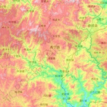
Name: 寿宁县 topographic map, elevation, terrain.
Location: 寿宁县, 宁德市, 福建省, 中国 (27.17092 119.23615 27.67944 119.73457)
Average elevation: 2,451 ft
Minimum elevation: 95 ft
Maximum elevation: 5,272 ft
属亚热带海洋性季风气候,境内海拔跨度大,垂直差异明显,昼夜温差大,雨量充沛,四季分明。全县山地面积1167.2平方公里,占总面积的88.9%,有“九山半水半分田”的说法。最高峰山羊尖海拔1649米,最低的武曲村海拔只有60米。
Other topographic maps
Click on a map to view its topography, its elevation and its terrain.
武夷山国家级风景名胜区
武夷山国家级风景名胜区, 武夷街道, 武夷山市, 南平市, 福建省, 354300, 中国
Average elevation: 991 ft