
莆田市 topographic map
Interactive map
Click on the map to display elevation.
About this map
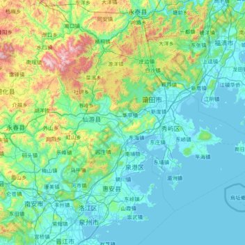
Name: 莆田市 topographic map, elevation, terrain.
Location: 莆田市, 福建省, 中国 (24.92505 118.45456 25.76367 119.73450)
Average elevation: 804 ft
Minimum elevation: -10 ft
Maximum elevation: 5,810 ft
Other topographic maps
Click on a map to view its topography, its elevation and its terrain.
武夷山国家级风景名胜区
武夷山国家级风景名胜区, 武夷街道, 武夷山市, 南平市, 福建省, 354300, 中国
Average elevation: 991 ft