
郭坑镇 topographic map
Interactive map
Click on the map to display elevation.
About this map
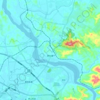
Name: 郭坑镇 topographic map, elevation, terrain.
Location: 郭坑镇, 龙文区, 漳州市, 福建省, 中国 (24.52914 117.70407 24.60876 117.81280)
Average elevation: 95 ft
Minimum elevation: -3 ft
Maximum elevation: 817 ft
Other topographic maps
Click on a map to view its topography, its elevation and its terrain.
武夷山国家级风景名胜区
武夷山国家级风景名胜区, 武夷街道, 武夷山市, 南平市, 福建省, 354300, 中国
Average elevation: 991 ft