
Costa Rica topographic map
Interactive map
Click on the map to display elevation.
About this map
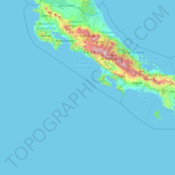
Name: Costa Rica topographic map, elevation, terrain.
Location: Costa Rica (5.49916 -87.10200 11.21957 -82.42990)
Average elevation: 331 ft
Minimum elevation: 0 ft
Maximum elevation: 12,215 ft
Other topographic maps
Click on a map to view its topography, its elevation and its terrain.
La Jolla
United States > California > San Diego County > San Diego > La Jolla
Average elevation: 121 ft
Hilo
United States of America > Hawaii > Hilo
Hilo has a tropical rainforest climate (Köppen Af), with substantial rainfall throughout the year. Its location on the windward coast (relative to the trade winds), makes it the fourth-wettest city in the United States, behind the southeast Alaskan cities of Whittier, Ketchikan and Yakutat, and one of the…
Average elevation: 1,027 ft
San Francisco Bay Area
United States > California > San Francisco
The San Francisco Bay Area is characterized by a diverse and dynamic topography shaped by geological processes over millions of years. This region features a combination of coastal plains, steep hills, and rugged mountains, all influenced by the tectonic activity associated with the nearby San Andreas Fault…
Average elevation: 371 ft
Golden Gate Park
United States > California > San Francisco
In the 1860s, San Franciscans began to feel the need for a spacious public park similar to Central Park, which was then taking shape in New York City. Golden Gate Park was carved out of unpromising sand and shore dunes that were known as the Outside Lands, in an unincorporated area west of San Francisco's…
Average elevation: 233 ft
Europe
Europe's topography is characterized by a striking contrast between its rugged southern mountains and the expansive plains of the north. The continent is often described as a "peninsula of peninsulas," featuring major peninsulas like the Iberian, Italian, and Balkan, each with unique geological features. In…
Average elevation: 732 ft
East Hampton
United States > New York > Suffolk County > East Hampton > Village of East Hampton
Average elevation: 39 ft
Pinetop-Lakeside
United States > Arizona > Navajo County
Pinetop-Lakeside is nestled in the stunning White Mountains of northeastern Arizona, characterized by a varied topography that significantly influences its natural beauty and recreational opportunities. The terrain features elevations averaging around 6,795 feet, with rugged mountain landscapes interspersed…
Average elevation: 6,847 ft
McKinleyville
United States > California > Humboldt County
McKinleyville (formerly Minorsville) is a census-designated place (CDP) in Humboldt County, California McKinleyville is located 5.25 miles (8.4 km) north of Arcata, at an elevation of 141 feet (43 m). The population was 15,177 at the 2010 census, up from 13,599 at the time of the 2000 census.
Average elevation: 161 ft
Aberdeen
United States > Washington > Grays Harbor County > Aberdeen
Aberdeen is at the eastern end of Grays Harbor, near the mouth of the Chehalis River and southwest of the Olympic Mountains. Grays Harbor is notable as the northernmost ria on North America's Pacific Coast because it has remained free of glaciers throughout the Quaternary due to unfavorable topography and warm…
Average elevation: 217 ft
San Pedro Hill
United States > California > Los Angeles County > Rancho Palos Verdes
Average elevation: 935 ft
Washington, D.C.
United States of America > Washington, D.C. > Washington, D.C.
The highest natural elevation in the District is 409 feet (125 m) above sea level at Fort Reno Park in upper northwest Washington. The lowest point is sea level at the Potomac River. The geographic center of Washington is near the intersection of 4th and L Streets NW.
Average elevation: 207 ft
Quezon City
Quezon City is characterized by a diverse topography that features a mix of flatlands, rolling hills, and elevated areas, particularly in the eastern and northern parts of the city. The elevation generally ranges from about 25 to 300 feet above sea level, with higher elevations found in areas like the La Mesa…
Average elevation: 187 ft
Englewood
Englewood features a diverse topography characterized by flat coastal plains and gently rolling terrain. The area is predominantly low-lying, with elevations rarely exceeding 20 feet above sea level, making it susceptible to tidal influences from the Gulf of Mexico. The landscape is interspersed with wetlands,…
Average elevation: 10 ft
Himalayas
Nepal > Koshi Province > Solukhumbu
The Himalayas present a dramatic and varied topography characterized by towering peaks, deep valleys, and extensive glaciers. This majestic mountain range features some of the highest elevations on Earth, including Mount Everest, which rises to 29,035 feet. The terrain is marked by steep, jagged ridges and…
Average elevation: 24,787 ft
Fairbanks
United States > Alaska > Fairbanks North Star
Fairbanks is situated within the central Tanana Valley, characterized by a diverse and dynamic topography. The city straddles the Chena River, which flows southwest into the larger Tanana River, defining Fairbanks' southern border. To the north, a gradual incline leads into a chain of hills that ascend toward…
Average elevation: 479 ft
Sebastopol
United States > California > Sonoma County
Sebastopol's elevation is 65 to 250 feet (20 to 76 meters) above sea level. Its downtown is at the intersection of State Route 12 and State Route 116 (Gravenstein Highway), approximately 9 mi (14 km) west of U.S. Route 101.
Average elevation: 226 ft
Monterrey
Mexico > Nuevo León > Monterrey
The city of Monterrey is 540 metres (1,770 ft) above sea level in the northeastern state of Nuevo León. Monterrey translated literally from Spanish to English is "King Mount" or "King Mountain", and folk etymology claims that this refers to the city's topography and the large mountains that surround it…
Average elevation: 2,470 ft
Appalachian Mountains
United States > North Carolina > Yancey County
The Appalachian Mountains (French: Appalaches), often called the Appalachians, are a system of mountains in eastern to northeastern North America. The Appalachians first formed roughly 480 million years ago during the Ordovician Period. They once reached elevations similar to those of the Alps and the Rocky…
Average elevation: 4,800 ft
North America
North America's topography is characterized by its diverse and dramatic landscapes, stretching from the towering Rocky Mountains in the west to the expansive Great Plains in the central region, and the rugged Appalachian Mountains in the east. The Rocky Mountains, which include peaks exceeding 20,000 feet…
Average elevation: 965 ft
Fairhope
United States > Alabama > Baldwin County > Fairhope
According to the U.S. Census Bureau, the city has a total area of 12.0 square miles (31.1 km2), of which 0.019 square mile (0.05 km2), or 0.16%, is water. Its elevation ranges from sea level at the bay to 122 feet (37 m) in the city center.
Average elevation: 115 ft
Silver Lake
United States > Colorado > Larimer County > Loveland > Browns Corner
Average elevation: 5,000 ft
Boise
United States > Idaho > Ada County
Boise (locally /ˈbɔɪsi/ BOY-see) is the capital and most populous city of the U.S. state of Idaho and is the county seat of Ada County. As of the 2020 census, there were 235,684 people residing in the city. On the Boise River in southwestern Idaho, it is 41 miles (66 km) east of the Oregon border and 110…
Average elevation: 3,412 ft
Carolina Harbor
United States > North Carolina > Mecklenburg County > Charlotte
Average elevation: 614 ft
El Dorado Hills
United States > California > El Dorado County > Cameron Park
El Dorado Hills (EDH), as defined by the 2010 census-designated place (CDP), is at the western border of El Dorado County, between the City of Folsom and the unincorporated community of Cameron Park. The northern limits of the CDP are Folsom Lake and the South Fork of the American River, where river rafters…
Average elevation: 833 ft
Crested Butte
United States > Colorado > Gunnison County
At the 2020 United States Census, the town had a total area of 535 acres (2.166 km2), all of it land. Crested Butte lies at an elevation of 8,885 feet (2,708 m) above sea level.
Average elevation: 9,180 ft
Palm Harbor
United States > Florida > Pinellas County
Palm Harbor is characterized by its unique topography, which features a relatively rare hilly landscape for the region. Unlike much of the surrounding areas in Pinellas County, which are predominantly flat, Palm Harbor includes elevations that can reach up to about 75 feet above sea level. This elevation gives…
Average elevation: 30 ft
Baltimore
Baltimore exhibits a diverse topography that plays a significant role in its character and development. Situated along the Patapsco River, which flows into the Chesapeake Bay, the city is positioned on the fall line that separates the Piedmont Plateau to the west from the Atlantic Coastal Plain to the east.…
Average elevation: 213 ft
Indianapolis
United States > Indiana > Indianapolis
Indianapolis is within the Tipton Till Plain, a flat to gently sloping terrain underlain by glacial deposits known as till. The lowest point in the city is about 650 feet (198 m) above mean sea level, with the highest natural elevation at about 900 feet (274 m) above sea level. Few hills or short ridges, known…
Average elevation: 791 ft
Flagstaff
United States > Arizona > Coconino County
Flagstaff, located in Coconino County, Arizona, is characterized by its diverse topography, primarily shaped by its high elevation and volcanic activity. Sitting at around 7,000 feet (approximately 2,130 meters), the city is surrounded by the expansive Coconino National Forest, which features a blend of…
Average elevation: 7,139 ft
Limeport
United States > Pennsylvania > Lehigh County > Lower Milford Township
Average elevation: 666 ft
Vandenberg Village
United States > California > Santa Barbara County > Lompoc
Average elevation: 433 ft
Sointula
Canada > British Columbia > Regional District of Mount Waddington > Area A (Seymour Inlet/Knight Inlet)
Average elevation: 118 ft
Denali State Park
United States > Alaska > Matanuska-Susitna Borough
Denali State Park is in sight of Denali, the highest mountain peak in North America, with a summit elevation of 20,310 feet above sea level. Denali rises 18,000 feet from base to peak, making it the largest mountain situated entirely above sea level. To the east, the state park borders the Susitna River, which…
Average elevation: 2,303 ft
Anna Maria island
United States > Florida > Manatee County
Anna Maria Island features a flat, sandy topography typical of a barrier island on the Gulf Coast. With an average elevation of around 15 feet above sea level, the terrain includes broad beaches, low dunes, and narrow stretches of sandy soil, making it highly vulnerable to storm surges and tidal flooding. The…
Average elevation: 7 ft
Hoover Dam
United States > Arizona > Mohave County
The amount of electricity generated by Hoover Dam has been decreasing along with the falling water level in Lake Mead due to the prolonged drought since year 2000 and high demand for the Colorado River's water. By 2014 its generating capacity was downrated by 23% to 1592 MW and was providing power only during…
Average elevation: 1,407 ft
Birmingham
United Kingdom > England > Birmingham
Birmingham is a snowy city relative to other large UK conurbations, due to its inland location and comparatively high elevation. Between 1961 and 1990 Birmingham Airport averaged 13.0 days of snow lying annually, compared to 5.33 at London Heathrow. Snow showers often pass through the city via the Cheshire gap…
Average elevation: 427 ft
Yucca Valley
United States > California > San Bernardino County
Yucca Valley lies in the middle of the Morongo Basin at a base elevation of 3,300 feet. Joshua Tree National Park is adjacent to its southern border.
Average elevation: 3,629 ft
Mauna Loa
United States > Hawaii > Hawaiʻi County
Mauna Loa is the largest subaerial and second largest overall volcano in the world (behind Tamu Massif), covering a land area of 5,271 km2 (2,035 sq mi) and spans a maximum width of 120 km (75 mi). Consisting of approximately 65,000 to 80,000 km3 (15,600 to 19,200 cu mi) of solid rock, it makes up more than…
Average elevation: 13,245 ft
Pollock Pines
United States > California > El Dorado County
Pollock Pines is a census-designated place (CDP) in El Dorado County, California, United States. It is part of the Sacramento–Arden-Arcade–Roseville Metropolitan Statistical Area. Pollock Pines lies at an elevation of 3,980 feet (1,210 m) in the Sierra Nevada. The population was 6,871 at the 2010 census,…
Average elevation: 3,681 ft
Diamondhead
United States > Mississippi > Hancock County
Much of the land that became Diamondhead had been purchased by Walter Gex, Sr., in 1937 from the Gulf State Paper Company and the Easy Opener Bag Company. Additional land was purchased by Gex, bringing his acquisition to nearly 5,000 acres (2,000 ha). In the late 1960s, D.E.A.R., Inc., later known as the…
Average elevation: 10 ft
Poughkeepsie
United States of America > New York > Poughkeepsie > Poughkeepsie
According to the United States Census Bureau, the city has an area of 5.7 square miles (14.8 km2), of which 5.1 square miles (13.3 km2) is land, and 0.23 square miles (0.6 km2) (10.05%) is water. Poughkeepsie lies approximately 75 miles (121 km) north of the center of the New York megacity. It is 73.5 miles…
Average elevation: 213 ft
Vinings
United States > Georgia > Cobb County
Vinings features a varied topography characterized by rolling hills and lush, wooded areas that provide a picturesque backdrop to the community. The area is nestled alongside the Chattahoochee River, which contributes to the gentle slopes and valleys that define the landscape. Elevations in Vinings typically…
Average elevation: 922 ft
Black Hills
United States > South Dakota > Pennington County
The Black Hills is an isolated mountain range rising from the Great Plains of North America in western South Dakota and extending into Wyoming, United States. Black Elk Peak, which rises to 7,242 feet (2,207 m), is the range's highest summit. The name of the range in Lakota is Pahá Sápa. It encompasses the…
Average elevation: 6,214 ft