
Make a donation
Gear up for your next adventure:
As an Amazon Associate, this site earns from qualifying purchases at no extra cost to you.
Stagecoach State Park topographic map
Click on the map to display elevation.
Make a donation
Gear up for your next adventure:
As an Amazon Associate, this site earns from qualifying purchases at no extra cost to you.
About this map
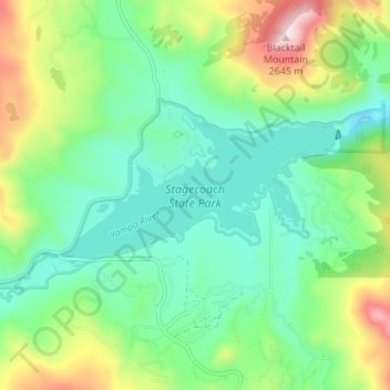
Name: Stagecoach State Park topographic map, elevation, terrain.
Average elevation: 7,546 ft
Minimum elevation: 7,064 ft
Maximum elevation: 8,658 ft
Colorado trails, hiking, mountain biking, running and outdoor activities
Make a donation
Gear up for your next adventure:
As an Amazon Associate, this site earns from qualifying purchases at no extra cost to you.
Other topographic maps
Click on a map to view its topography, its elevation and its terrain.
Denver
United States > Colorado > Denver County > Denver
Denver, situated at an elevation of 5,280 feet (1,609 meters), is renowned as the "Mile High City." It is located in the South Platte River Valley, just east of the Rocky Mountains' foothills. The city's topography features a gently sloping landscape characterized by rolling hills and wide valleys,…
Average elevation: 5,525 ft
Monument
United States > Colorado > Monument
Monument is situated at an elevation of approximately 7,000 feet (2,134 meters) within the Front Range of the Rocky Mountains, creating a diverse topography that is both striking and varied. The town is characterized by rolling hills and flat terrain in the valley, contrasted by the rugged foothills of the…
Average elevation: 6,998 ft
Make a donation
Gear up for your next adventure:
As an Amazon Associate, this site earns from qualifying purchases at no extra cost to you.
Montrose
United States > Colorado > Montrose County
Montrose features a semi-arid Continental climate zone. The town sits on high grasslands in the Uncompahgre Valley of Western Colorado. Snowfall occurs during the winter but is usually short-lived due to the high altitude and abundant sunshine.
Average elevation: 5,915 ft
Garden of the Gods
United States > Colorado > El Paso County > Colorado Springs
Average elevation: 6,463 ft
Make a donation
Gear up for your next adventure:
As an Amazon Associate, this site earns from qualifying purchases at no extra cost to you.
Make a donation
Gear up for your next adventure:
As an Amazon Associate, this site earns from qualifying purchases at no extra cost to you.
Cañon City
United States > Colorado > Fremont County > Cañon City > Cañon City
The city's nickname, "the Climate Capital of Colorado", derives from the combination of unique geography and 5,300-foot (1,600 m) elevation protecting the city from harsh weather conditions. The average daily high temperature in January is 14 °F (7.8 °C) warmer in Cañon City than in Grand Junction, even…
Average elevation: 5,479 ft
Denver
Denver is in the western United States, in the South Platte River Valley on the western edge of the High Plains just east of the Front Range of the Rocky Mountains. Its downtown district is immediately east of the confluence of Cherry Creek and the South Platte River, about 12 miles (19 kilometres) east of the…
Average elevation: 5,459 ft
Make a donation
Gear up for your next adventure:
As an Amazon Associate, this site earns from qualifying purchases at no extra cost to you.
Loveland Pass
Loveland Pass is a high mountain pass in north-central Colorado, at an elevation of 11,990 feet (3,655 m) above sea level in the Rocky Mountains of the Western United States.
Average elevation: 11,939 ft
Make a donation
Gear up for your next adventure:
As an Amazon Associate, this site earns from qualifying purchases at no extra cost to you.
Lafayette
United States > Colorado > Boulder County > Lafayette > Lafayette
Average elevation: 5,240 ft
Pike National Forest
Most of the forest experiences a Highland climate with warm summers and cold winters. Even in the summer, nights are cool due to the forest's high elevation. Temperatures and precipitation vary widely throughout the forest, depending on elevation. Most of the forest receives more than 100 inches of snow a year.
Average elevation: 8,425 ft
Make a donation
Gear up for your next adventure:
As an Amazon Associate, this site earns from qualifying purchases at no extra cost to you.
Guanella Pass
United States > Colorado > Clear Creek County
Guanella Pass (elevation 11,669 ft or 3,557 m) is a high mountain pass in central Colorado, in the Rocky Mountains of the western United States.
Average elevation: 11,568 ft
Make a donation
Gear up for your next adventure:
As an Amazon Associate, this site earns from qualifying purchases at no extra cost to you.
Rawah Wilderness
United States > Colorado > Larimer County
The Rawah Wilderness is administered by the USDA Forest Service. It is located on the Canyon Lakes Ranger District of the Roosevelt National Forest in Colorado, near the Wyoming border, and also in the Routt National Forest to its south. It encompasses 76,394 acres (309.16 km2) and includes 25 named lakes…
Average elevation: 9,508 ft
Make a donation
Gear up for your next adventure:
As an Amazon Associate, this site earns from qualifying purchases at no extra cost to you.
Boulder
United States > Colorado > Boulder County > Boulder
Boulder is located at the base of the foothills of the Rocky Mountains, at an elevation of 5,430 feet (1,655 m) above sea level. Boulder is 25 miles (40 km) northwest of the Colorado State Capitol in Denver. It is home of the main campus of the University of Colorado, the state's largest university.
Average elevation: 6,486 ft
Douglas Pass
United States > Colorado > Garfield County
Douglas Pass, elevation 8,205 feet (2,501 meters), is a mountain pass in the Book Cliffs of western Colorado. It is located in Garfield County and is traversed by State Highway 139. The pass divides the watersheds of West Douglas Creek to the north and East Salt Creek to the south. It is named for the Northern…
Average elevation: 7,989 ft
Gunnison
United States > Colorado > Gunnison County
Also in 1880, the cattle industry in Gunnison was established. Realizing the poor conditions for farming (with only about eleven inches of rainfall annually and the short growing season due to the high elevation and alpine environment) the local farmers turned to ranching and began breeding cattle. To do this…
Average elevation: 7,772 ft
Make a donation
Gear up for your next adventure:
As an Amazon Associate, this site earns from qualifying purchases at no extra cost to you.
Make a donation
Gear up for your next adventure:
As an Amazon Associate, this site earns from qualifying purchases at no extra cost to you.
Make a donation
Gear up for your next adventure:
As an Amazon Associate, this site earns from qualifying purchases at no extra cost to you.
Fort Garland
United States > Colorado > Costilla County
Fort Garland is located at an elevation of 7,936 ft (2,419 m) in northern Costilla County. Fort Garland is at the crossroads of U.S. Route 160 and Colorado State Highway 159, which leads south towards Taos and Santa Fe, New Mexico. The town of Blanca is 4 miles (6.4 km) west on U.S. Route 160. Walsenburg is 47…
Average elevation: 8,009 ft
Make a donation
Gear up for your next adventure:
As an Amazon Associate, this site earns from qualifying purchases at no extra cost to you.
Make a donation
Gear up for your next adventure:
As an Amazon Associate, this site earns from qualifying purchases at no extra cost to you.
Make a donation
Gear up for your next adventure:
As an Amazon Associate, this site earns from qualifying purchases at no extra cost to you.
Make a donation
Gear up for your next adventure:
As an Amazon Associate, this site earns from qualifying purchases at no extra cost to you.
Make a donation
Gear up for your next adventure:
As an Amazon Associate, this site earns from qualifying purchases at no extra cost to you.
Make a donation
Gear up for your next adventure:
As an Amazon Associate, this site earns from qualifying purchases at no extra cost to you.
Make a donation
Gear up for your next adventure:
As an Amazon Associate, this site earns from qualifying purchases at no extra cost to you.
Pawnee National Grassland
United States > Colorado > Weld County
The grassland is a part of the short grass plains of North America. The best example of this ecosystem are preserved around the Pawnee Buttes where grazing and intensive agriculture have had less impact. There are eleven vegetation zones represented with the most unique being the scarp woodlands on the north…
Average elevation: 4,954 ft
Make a donation
Gear up for your next adventure:
As an Amazon Associate, this site earns from qualifying purchases at no extra cost to you.
Stratton Meadows
United States > Colorado > El Paso County > Colorado Springs
Average elevation: 5,968 ft
Coal Bank Pass
United States > Colorado > San Juan County
Coal Bank Pass, elevation 10,640 feet (3,240 meters), is a mountain pass in the San Juan Mountains of western Colorado in the United States. The pass is in the San Juan National Forest.
Average elevation: 10,751 ft
Make a donation
Gear up for your next adventure:
As an Amazon Associate, this site earns from qualifying purchases at no extra cost to you.
Make a donation
Gear up for your next adventure:
As an Amazon Associate, this site earns from qualifying purchases at no extra cost to you.
Make a donation
Gear up for your next adventure:
As an Amazon Associate, this site earns from qualifying purchases at no extra cost to you.
Make a donation
Gear up for your next adventure:
As an Amazon Associate, this site earns from qualifying purchases at no extra cost to you.
Make a donation
Gear up for your next adventure:
As an Amazon Associate, this site earns from qualifying purchases at no extra cost to you.
Hallett Peak
United States > Colorado > Larimer County
According to the Köppen climate classification system, Hallett Peak is located in an alpine subarctic climate zone with cold, snowy winters, and cool to warm summers. Due to its altitude, it receives precipitation all year, as snow in winter and as thunderstorms in summer, with a dry period in late spring.
Average elevation: 11,736 ft
Make a donation
Gear up for your next adventure:
As an Amazon Associate, this site earns from qualifying purchases at no extra cost to you.