
Make a donation
Gear up for your next adventure:
As an Amazon Associate, this site earns from qualifying purchases at no extra cost to you.
Dominican Republic topographic map
Click on the map to display elevation.
Make a donation
Gear up for your next adventure:
As an Amazon Associate, this site earns from qualifying purchases at no extra cost to you.
Dominican Republic
There are many lakes and coastal lagoons. The largest lake is Enriquillo, a salt lake at 45 metres (148 ft) below sea level, the lowest elevation in the Caribbean. Other important lakes are Laguna de Rincón or Cabral, with fresh water, and Laguna de Oviedo, a lagoon with brackish water.
Make a donation
Gear up for your next adventure:
As an Amazon Associate, this site earns from qualifying purchases at no extra cost to you.
About this map
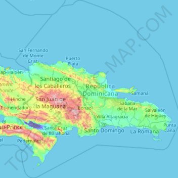
Name: Dominican Republic topographic map, elevation, terrain.
Location: Dominican Republic (17.27017 -72.06963 21.29288 -68.11015)
Average elevation: 413 ft
Minimum elevation: -144 ft
Maximum elevation: 9,780 ft
Make a donation
Gear up for your next adventure:
As an Amazon Associate, this site earns from qualifying purchases at no extra cost to you.
Other topographic maps
Click on a map to view its topography, its elevation and its terrain.
San Francisco Bay Area
United States > California > San Francisco
The San Francisco Bay Area is characterized by a diverse and dynamic topography shaped by geological processes over millions of years. This region features a combination of coastal plains, steep hills, and rugged mountains, all influenced by the tectonic activity associated with the nearby San Andreas Fault…
Average elevation: 371 ft
City of London
United Kingdom > England > City of London > City of London
The elevation of the City ranges from sea level at the Thames to 21.6 metres (71 ft) at the junction of High Holborn and Chancery Lane. Two small but notable hills are within the historic core, Ludgate Hill to the west and Cornhill to the east. Between them ran the Walbrook, one of the many "lost" rivers or…
Average elevation: 138 ft
Vanambouani فانامبواني
Comoros > Grande Comore > Itsandra-Hamanvou > Mbadani
Average elevation: 253 ft
Flagstaff
United States > Arizona > Coconino County
Flagstaff, located in Coconino County, Arizona, is characterized by its diverse topography, primarily shaped by its high elevation and volcanic activity. Sitting at around 7,000 feet (approximately 2,130 meters), the city is surrounded by the expansive Coconino National Forest, which features a blend of…
Average elevation: 7,139 ft
Make a donation
Gear up for your next adventure:
As an Amazon Associate, this site earns from qualifying purchases at no extra cost to you.
Baltimore
Baltimore exhibits a diverse topography that plays a significant role in its character and development. Situated along the Patapsco River, which flows into the Chesapeake Bay, the city is positioned on the fall line that separates the Piedmont Plateau to the west from the Atlantic Coastal Plain to the east.…
Average elevation: 213 ft
Lipa
Philippines > Batangas > Lipa > Lipa
At the celebration of the elevation of Lipa to a city in January 1888, José Rizal was invited by Dr. Jose Lozada, Catalino Dimayuga and the brothers Celestino and Simeon Luz but Rizal responded only with his Hymno Al Trabajo which he dedicated to the zeal and industry of the Lipeños.
Average elevation: 535 ft
North America
North America's topography is characterized by its diverse and dramatic landscapes, stretching from the towering Rocky Mountains in the west to the expansive Great Plains in the central region, and the rugged Appalachian Mountains in the east. The Rocky Mountains, which include peaks exceeding 20,000 feet…
Average elevation: 965 ft
Make a donation
Gear up for your next adventure:
As an Amazon Associate, this site earns from qualifying purchases at no extra cost to you.
Albrightsville
United States > Pennsylvania > Carbon County > Kidder Township
Average elevation: 1,634 ft
Himalayas
Nepal > Koshi Province > Solukhumbu
The Himalayas present a dramatic and varied topography characterized by towering peaks, deep valleys, and extensive glaciers. This majestic mountain range features some of the highest elevations on Earth, including Mount Everest, which rises to 29,035 feet. The terrain is marked by steep, jagged ridges and…
Average elevation: 24,787 ft
East Hampton
United States > New York > Suffolk County > East Hampton > Village of East Hampton
Average elevation: 39 ft
Make a donation
Gear up for your next adventure:
As an Amazon Associate, this site earns from qualifying purchases at no extra cost to you.
Port Charlotte
United States > Florida > Charlotte County
Port Charlotte is characterized by a predominantly flat and low-lying terrain, typical of Florida’s coastal landscape. The area features a network of waterways, including the Peace River and Charlotte Harbor, which provide ample opportunities for recreational activities like boating and fishing. Elevations…
Average elevation: 13 ft
Appalachian Mountains
United States > North Carolina > Yancey County
The Appalachian Mountains (French: Appalaches), often called the Appalachians, are a system of mountains in eastern to northeastern North America. The Appalachians first formed roughly 480 million years ago during the Ordovician Period. They once reached elevations similar to those of the Alps and the Rocky…
Average elevation: 4,800 ft
Fairbanks
United States > Alaska > Fairbanks North Star
Fairbanks is situated within the central Tanana Valley, characterized by a diverse and dynamic topography. The city straddles the Chena River, which flows southwest into the larger Tanana River, defining Fairbanks' southern border. To the north, a gradual incline leads into a chain of hills that ascend toward…
Average elevation: 479 ft
Make a donation
Gear up for your next adventure:
As an Amazon Associate, this site earns from qualifying purchases at no extra cost to you.
Central Park
United States > New York > New York County > New York
In June 1856, Fernando Wood appointed a "consulting board" of seven people, headed by author Washington Irving, to inspire public confidence in the proposed development. Wood hired military engineer Egbert Ludovicus Viele as the park's chief engineer, tasking him with a topographical survey of the site. The…
Average elevation: 85 ft
Africa
Africa's topography is a complex tapestry of plateaus, mountains, valleys, and deserts. The continent is dominated by vast plateaus, with elevations averaging around 1,000 meters (3,281 feet), especially prominent in the south and east. The Ethiopian Highlands, often referred to as the "Roof of Africa," rise…
Average elevation: 1,516 ft
Make a donation
Gear up for your next adventure:
As an Amazon Associate, this site earns from qualifying purchases at no extra cost to you.
Denver
Denver is in the western United States, in the South Platte River Valley on the western edge of the High Plains just east of the Front Range of the Rocky Mountains. Its downtown district is immediately east of the confluence of Cherry Creek and the South Platte River, about 12 miles (19 kilometres) east of the…
Average elevation: 5,459 ft
Augusta
United States > Georgia > Augusta
As with the rest of the state, Augusta has a humid subtropical climate (Köppen Cfa), with short, mild winters, very hot, humid summers, and a wide diurnal temperature variation throughout much of the year, despite its low elevation and moisture. The monthly daily average temperature ranges from 45.4 °F (7.4…
Average elevation: 295 ft
Matsulu
South Africa > Mpumalanga > Ehlanzeni District Municipality > Mbombela
Average elevation: 1,473 ft
Make a donation
Gear up for your next adventure:
As an Amazon Associate, this site earns from qualifying purchases at no extra cost to you.
El Dorado Hills
United States > California > El Dorado County > Cameron Park
El Dorado Hills (EDH), as defined by the 2010 census-designated place (CDP), is at the western border of El Dorado County, between the City of Folsom and the unincorporated community of Cameron Park. The northern limits of the CDP are Folsom Lake and the South Fork of the American River, where river rafters…
Average elevation: 833 ft
Cuyahoga River
United States > Ohio > Cuyahoga County > Cleveland
The upper Cuyahoga River, starting at 1,093 feet (333 m) over 84 miles (135 km) from its mouth, drops in elevation fairly steeply, creating falls and rapids in some places; the lower Cuyahoga River only drops several feet along the last several miles of the lower river to 571 feet (174 m) at the mouth on Lake…
Average elevation: 643 ft
Make a donation
Gear up for your next adventure:
As an Amazon Associate, this site earns from qualifying purchases at no extra cost to you.
Indianapolis
United States > Indiana > Indianapolis
Indianapolis is within the Tipton Till Plain, a flat to gently sloping terrain underlain by glacial deposits known as till. The lowest point in the city is about 650 feet (198 m) above mean sea level, with the highest natural elevation at about 900 feet (274 m) above sea level. Few hills or short ridges, known…
Average elevation: 791 ft
Make a donation
Gear up for your next adventure:
As an Amazon Associate, this site earns from qualifying purchases at no extra cost to you.
Carletonville
South Africa > Gauteng > West Rand District Municipality > Merafong City Local Municipality
Average elevation: 5,049 ft
Make a donation
Gear up for your next adventure:
As an Amazon Associate, this site earns from qualifying purchases at no extra cost to you.
Glenside
United States > Pennsylvania > Montgomery County > Abington Township
Average elevation: 308 ft
Make a donation
Gear up for your next adventure:
As an Amazon Associate, this site earns from qualifying purchases at no extra cost to you.
Huntington Beach
United States > California > Orange County > Huntington Beach
Average elevation: 52 ft
Lutz
United States > Florida > Hillsborough County > Tampa
Lutz is characterized by a gently rolling topography that showcases the distinctive features of the central Florida landscape. The area has an average elevation of about 70 feet (21 meters) above sea level, contributing to its mild undulations rather than dramatic elevation changes. The terrain is marked by a…
Average elevation: 66 ft
Make a donation
Gear up for your next adventure:
As an Amazon Associate, this site earns from qualifying purchases at no extra cost to you.
Santa Cruz Mountains
United States > California > Santa Clara County
The Santa Cruz Mountains are a region of great biological diversity, encompassing cool, moist coastal ecosystems as well as warm, dry chaparral. Much of the area in the Santa Cruz mountains is considered temperate rainforest. In valleys and moist ocean-facing slopes some of the southernmost coast redwoods…
Average elevation: 755 ft
South America
South America's topography is marked by remarkable diversity and dramatic contrasts. The continent is dominated by the Andes mountain range, which runs along its western edge, stretching over 4,300 miles from Venezuela to Chile. These mountains are home to some of the highest peaks in the Western Hemisphere,…
Average elevation: 928 ft
Denali
United States > Alaska > Denali Borough
Denali (/dəˈnɑːli/ də-NAH-lee), federally designated as Mount McKinley, is the highest mountain peak in North America, with a summit elevation of 20,310 feet (6,190 m) above sea level. It is the tallest mountain in the world from base to peak on land, measuring 18,000 ft (5,500 m). With a topographic…
Average elevation: 18,196 ft
Make a donation
Gear up for your next adventure:
As an Amazon Associate, this site earns from qualifying purchases at no extra cost to you.
Mount Fuji
Japan > Sunto County > Oyama
Mount Fuji (富士山, Fujisan, Japanese: [ɸɯꜜ(d)ʑisaɴ] (listen)), or Fugaku, located on the island of Honshū, is the highest mountain in Japan, with a summit elevation of 3,776.24 m (12,389 ft 3 in). It is the second-highest volcano located on an island in Asia (after Mount Kerinci on the island of…
Average elevation: 10,709 ft
Fairhope
United States > Alabama > Baldwin County > Fairhope
According to the U.S. Census Bureau, the city has a total area of 12.0 square miles (31.1 km2), of which 0.019 square mile (0.05 km2), or 0.16%, is water. Its elevation ranges from sea level at the bay to 122 feet (37 m) in the city center.
Average elevation: 115 ft
Make a donation
Gear up for your next adventure:
As an Amazon Associate, this site earns from qualifying purchases at no extra cost to you.
Buena Vista
United States > Colorado > Chaffee County
Buena Vista is located in central Colorado roughly midway between Salida and Leadville in the Upper Arkansas River Valley at an elevation of 7,965 feet (2,428 m). The area between Buena Vista and Salida is often referred to as the Denver & Rio Grande, South Park & Pacific, and Colorado Midland railroads. Many…
Average elevation: 8,061 ft
Make a donation
Gear up for your next adventure:
As an Amazon Associate, this site earns from qualifying purchases at no extra cost to you.
Tucson
United States > Arizona > Pima County > Tucson
The city's elevation is 2,643 ft (806 m) above sea level (as measured at the Tucson International Airport). Tucson is on an alluvial plain in the Sonoran Desert, surrounded by five minor ranges of mountains: the Santa Catalina Mountains and the Tortolita Mountains to the north, the Santa Rita Mountains to the…
Average elevation: 2,743 ft
Mount Everest
Nepal > Koshi Province > Solukhumbu
Mount Everest (Nepali: सगरमाथा, romanized: Sagarmāthā; Tibetan: Chomolungma ཇོ་མོ་གླང་མ; Chinese: 珠穆朗玛峰; pinyin: Zhūmùlǎngmǎ Fēng) is Earth's highest mountain above sea level, located in the Mahalangur Himal sub-range of the Himalayas. The China–Nepal…
Average elevation: 25,755 ft
Madison
United States > Wisconsin > Dane County
The city is sometimes described as The City of Four Lakes, comprising the four successive lakes of the Yahara River: Lake Mendota ("Fourth Lake"), Lake Monona ("Third Lake"), Lake Waubesa ("Second Lake") and Lake Kegonsa ("First Lake"), although Waubesa and Kegonsa are not actually in Madison, but just south…
Average elevation: 948 ft
Make a donation
Gear up for your next adventure:
As an Amazon Associate, this site earns from qualifying purchases at no extra cost to you.
Hudson
United States > Florida > Hudson
Hudson features a predominantly flat and low-lying topography typical of the region, with an average elevation of approximately 16 feet above sea level. This terrain is interspersed with various wetlands and small lakes, creating a rich ecosystem that supports diverse wildlife. The area also includes a few…
Average elevation: 16 ft
Erie Canal
United States > New York > Erie County > City of Tonawanda
The construction of the Erie Canal was a landmark civil engineering achievement in the early history of the United States. When built, the 363-mile (584 km) canal was the second-longest in the world (after the Grand Canal in China). Initially 40 feet (12 m) wide and 4 feet (1.2 m) deep, the canal was expanded…
Average elevation: 581 ft
Make a donation
Gear up for your next adventure:
As an Amazon Associate, this site earns from qualifying purchases at no extra cost to you.
Parrish
United States > Florida > Manatee County
Parrish features a predominantly flat terrain with an average elevation of approximately 36 feet above sea level. The area's landscape is characterized by gently rolling hills and low-lying regions, making it typical of the Central Florida topography. Surrounding Parrish are numerous wetlands and drainage…
Average elevation: 39 ft
Make a donation
Gear up for your next adventure:
As an Amazon Associate, this site earns from qualifying purchases at no extra cost to you.
Johnston Island
The climate is tropical but generally dry. Northeast trade winds are consistent and there is little seasonal temperature variation. With elevation ranging from sea level to 5 m (16 ft) at Summit Peak, the islands contain some low-growing vegetation and palm trees on mostly flat terrain, and no natural fresh…
Average elevation: 3 ft
Make a donation
Gear up for your next adventure:
As an Amazon Associate, this site earns from qualifying purchases at no extra cost to you.
East Texas
United States > Pennsylvania > Lehigh County > Lower Macungie Township
Average elevation: 413 ft
Make a donation
Gear up for your next adventure:
As an Amazon Associate, this site earns from qualifying purchases at no extra cost to you.
Jayne's Hill
United States > New York > Suffolk County > Town of Huntington
Jayne's Hill (also known as High Hill, West Hills, Oakley's Hill, and Janes Hill) is the highest point on Long Island, New York, with an elevation of between 387 feet (118 m) and 400.9 feet (122.2 m) above sea level. It is situated on the Harbor Hill moraine, a terminal moraine that makes up the northern spine…
Average elevation: 240 ft
Blue Ridge
United States > Virginia > Loudoun County
Blue Ridge Mountain is noticeably lower in elevation than other sections of the Blue Ridge Mountains in Virginia. The southern section of the mountain contains the highest peaks, and the ridge gradually loses elevation as it gets closer to the Potomac. Elevations in the gaps are typically around 1,000 feet…
Average elevation: 600 ft
Saint Petersburg
United States > Florida > Pinellas County > Saint Petersburg
Average elevation: 10 ft
Make a donation
Gear up for your next adventure:
As an Amazon Associate, this site earns from qualifying purchases at no extra cost to you.
Air Force Academy
United States > Colorado > El Paso County > Colorado Springs
The campus of the academy covers 18,455 acres (29 sq mi; 75 km2) on the east side of the Rampart Range of the Rocky Mountains, just north of Colorado Springs. Its elevation is normally given as 7,258 feet (2,212 m) above sea level, which is at the cadet area. The academy was designed by Skidmore, Owings and…
Average elevation: 7,080 ft
Wake Island
On November 1, 2015, a complex $230 million U.S. military missile defense system test event, called Campaign Fierce Sentry Flight Test Operational-02 Event 2 (FTO-02 E2), was conducted at Wake Island and the surrounding ocean areas. The test involved a Terminal High Altitude Area Defense (THAAD) system built…
Average elevation: 3 ft
Make a donation
Gear up for your next adventure:
As an Amazon Associate, this site earns from qualifying purchases at no extra cost to you.
Make a donation
Gear up for your next adventure:
As an Amazon Associate, this site earns from qualifying purchases at no extra cost to you.
Atlanta
United States > Georgia > Fulton County
Atlanta (/ætˈlæntə/ at-LAN-tə) is the capital and most populous city of the U.S. state of Georgia. It is the seat of Fulton County, the most populous county in Georgia. With a population of 498,715 living within the city limits, it is the eighth most populous city in the Southeast and 38th most populous…
Average elevation: 935 ft
Elizabeth City
United States of America > North Carolina > Elizabeth City
According to the United States Census Bureau, Elizabeth City has a total area of 12.2 square miles (31.7 km2), of which 11.6 square miles (30.1 km2) is land and 0.62 square miles (1.6 km2), or 5.09%, is water. Located in the "Inner Banks" region of North Carolina, Elizabeth City is largely flat and marshy with…
Average elevation: 13 ft
Washington, D.C.
United States of America > Washington, D.C. > Washington, D.C.
The highest natural elevation in the District is 409 feet (125 m) above sea level at Fort Reno Park in upper northwest Washington. The lowest point is sea level at the Potomac River. The geographic center of Washington is near the intersection of 4th and L Streets NW.
Average elevation: 207 ft
Make a donation
Gear up for your next adventure:
As an Amazon Associate, this site earns from qualifying purchases at no extra cost to you.
Pebble Beach
United States > California > Monterey County > Del Monte Forest
Average elevation: 174 ft
Palmyra Atoll
In 1962, the Department of Defense used Palmyra as an observation site during several high-altitude nuclear weapons tests high above Johnston Atoll. A group of about ten men supported the observation posts during this series of tests, while about 40 people carried out the observations.
Average elevation: 0 ft
Make a donation
Gear up for your next adventure:
As an Amazon Associate, this site earns from qualifying purchases at no extra cost to you.
Make a donation
Gear up for your next adventure:
As an Amazon Associate, this site earns from qualifying purchases at no extra cost to you.