
Wake Island topographic map
Click on the map to display elevation.
Wake Island
On November 1, 2015, a complex $230 million U.S. military missile defense system test event, called Campaign Fierce Sentry Flight Test Operational-02 Event 2 (FTO-02 E2), was conducted at Wake Island and the surrounding ocean areas. The test involved a Terminal High Altitude Area Defense (THAAD) system built by Lockheed Martin, two AN/TPY-2 radar systems built by Raytheon, Lockheed's Command, Control, Battle Management, and Communications system, and USS John Paul Jones guided missile destroyer with its AN/SPY-1 radar. The objective was to test the ability of the Aegis Ballistic Missile Defense and THAAD Weapon Systems to defeat a raid of three near-simultaneous air and missile targets, consisting of one medium-range ballistic missile, one short-range ballistic missile and one cruise missile target. During the test, a THAAD system on Wake Island detected and destroyed a short-range target simulating a short-range ballistic missile that was launched by a C-17 transport plane. At the same time, the THAAD system and the destroyer both launched missiles to intercept a medium-range ballistic missile, launched by a second C-17.
About this map
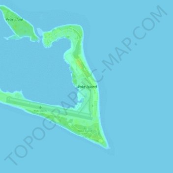
Name: Wake Island topographic map, elevation, terrain.
Location: Wake Island, United States (19.26998 166.59904 19.30979 166.65738)
Average elevation: 3 ft
Minimum elevation: 0 ft
Maximum elevation: 52 ft
United States trails, hiking, mountain biking, running and outdoor activities
Other topographic maps
Click on a map to view its topography, its elevation and its terrain.
Denver
United States > Colorado > Denver County > Denver
Denver, situated at an elevation of 5,280 feet (1,609 meters), is renowned as the "Mile High City." It is located in the South Platte River Valley, just east of the Rocky Mountains' foothills. The city's topography features a gently sloping landscape characterized by rolling hills and wide valleys,…
Average elevation: 5,525 ft
Atlanta
United States > Georgia > Fulton County
Atlanta occupies a high, rolling part of the Georgia Piedmont, a physiographic region described as a landscape of low hills and narrow valleys between the Blue Ridge Mountains and the Upper Coastal Plain. Around downtown and Fulton County, the terrain is gently dissected rather than flat, with broad urban…
Average elevation: 935 ft
Puerto Rico
Puerto Rico features a diverse topography characterized by a mountainous interior, coastal plains, and stunning beaches. The island's central region is dominated by the Cordillera Central mountain range, which includes the highest peak, Cerro de Punta, rising to 4,390 feet (1,338 meters). These mountains…
Average elevation: 213 ft
Chesapeake Bay
Tides in the Chesapeake Bay exhibit an interesting and unique behavior due to the nature of the topography (both horizontal and vertical shape), wind-driven circulation, and how the Bay interacts with oceanic tides. Research into the peculiar behavior of tides both at the northern and southern extents of the…
Average elevation: 108 ft
Baltimore
Baltimore exhibits a diverse topography that plays a significant role in its character and development. Situated along the Patapsco River, which flows into the Chesapeake Bay, the city is positioned on the fall line that separates the Piedmont Plateau to the west from the Atlantic Coastal Plain to the east.…
Average elevation: 213 ft
Kingman
United States > Arizona > Mohave County > Kingman
Lt. Edward Fitzgerald Beale, a U.S. Navy officer in the service of the U.S. Army Corps of Topographical Engineers, was ordered by the U.S. War Department to build a federal wagon road across the 35th Parallel. His secondary orders were to test the feasibility of the use of camels as pack animals in the…
Average elevation: 3,711 ft
Guildhall
United States > Vermont > Essex County
The highest point is Stone Mountain, in the western part of town, with an elevation of 2,736 feet (834 m).
Average elevation: 1,152 ft
Old Hickory Lake
United States > Tennessee > Wilson County > Mount Juliet
Old Hickory Lake is a mainstream storage impoundment on the Cumberland River operated by the U.S. Army Corps of Engineers. The reservoir contains 22,500 acres (91 km2) at an elevation of 445 feet (above sea level) and extends 97.3 river miles. Water level fluctuations are minimal with minimum pool elevation at…
Average elevation: 561 ft
Tucson
United States > Arizona > Pima County > Tucson
The city's elevation is 2,643 ft (806 m) above sea level (as measured at the Tucson International Airport). Tucson is on an alluvial plain in the Sonoran Desert, surrounded by five minor ranges of mountains: the Santa Catalina Mountains and the Tortolita Mountains to the north, the Santa Rita Mountains to the…
Average elevation: 2,743 ft
Big Bear Lake
United States > California > San Bernardino County > Big Bear Lake
At a surface elevation of 6,743 ft (2,055 m) above sea level, it has an east-west length of approximately seven miles (11 km) and is approximately 2.5 miles (4.0 km) at its widest measurement, though the lake's width mostly averages a little more than 1⁄2 mi (0.8 km). These approximations are based on the…
Average elevation: 7,247 ft
Pinetop-Lakeside
United States > Arizona > Navajo County
Pinetop-Lakeside is nestled in the stunning White Mountains of northeastern Arizona, characterized by a varied topography that significantly influences its natural beauty and recreational opportunities. The terrain features elevations averaging around 6,795 feet, with rugged mountain landscapes interspersed…
Average elevation: 6,847 ft
Augusta
United States > Georgia > Augusta
As with the rest of the state, Augusta has a humid subtropical climate (Köppen Cfa), with short, mild winters, very hot, humid summers, and a wide diurnal temperature variation throughout much of the year, despite its low elevation and moisture. The monthly daily average temperature ranges from 45.4 °F (7.4…
Average elevation: 295 ft
Beaver Lake
United States > Arkansas > Benton County > Goshen
Beaver Dam was authorized by the Flood Control Act of 1944 and other following acts. The United States Army Corps of Engineers constructed Beaver Dam during the years 1960-1966, impounding a major part of the White River and creating Beaver Lake and flooding much of the valley including the remains of the…
Average elevation: 1,286 ft
Bald Head Island
United States > North Carolina > Brunswick County > Bald Head Island
Average elevation: 10 ft
Gunnison
United States > Colorado > Gunnison County
Also in 1880, the cattle industry in Gunnison was established. Realizing the poor conditions for farming (with only about eleven inches of rainfall annually and the short growing season due to the high elevation and alpine environment) the local farmers turned to ranching and began breeding cattle. To do this…
Average elevation: 7,772 ft
Montrose
United States > Colorado > Montrose County
Montrose features a semi-arid Continental climate zone. The town sits on high grasslands in the Uncompahgre Valley of Western Colorado. Snowfall occurs during the winter but is usually short-lived due to the high altitude and abundant sunshine.
Average elevation: 5,915 ft
Lake Norman
United States > North Carolina > Iredell County > Mooresville
Lake Norman and the surrounding shoreline serve as a habitat for a diverse array of plants and wildlife, as well as a place for a myriad of human activities. Maintaining this habitat to simultaneously preserve endangered species, keep invasive species at bay, and maintain health and safety standards for the…
Average elevation: 833 ft
Fort Irwin
United States > California > San Bernardino County
Fort Irwin National Training Center (Fort Irwin NTC) is a major training area for the United States military in the Mojave Desert in northern San Bernardino County, California. Fort Irwin is at an average elevation of 2,454 feet (748 m). It is located 37 miles (60 km) northeast of Barstow, in the Calico…
Average elevation: 2,539 ft
Indianapolis
United States > Indiana > Indianapolis
Indianapolis is within the Tipton Till Plain, a flat to gently sloping terrain underlain by glacial deposits known as till. The lowest point in the city is about 650 feet (198 m) above mean sea level, with the highest natural elevation at about 900 feet (274 m) above sea level. Few hills or short ridges, known…
Average elevation: 791 ft
Lafayette
United States > Colorado > Boulder County > Lafayette > Lafayette
Average elevation: 5,240 ft
Minneapolis
United States > Minnesota > Hennepin County > Minneapolis
A 1959 report by the U.S. Soil Conservation Service listed Minneapolis's elevation as 830 feet (250 m). The city's lowest elevation of 687 feet (209 m) above sea level is near where Minnehaha Creek meets the Mississippi River. Sources disagree on the exact location and elevation of the city's highest point,…
Average elevation: 889 ft
Port Jefferson
United States > New York > Suffolk County > Port Jefferson > Port Jefferson
It wasn't until 1836 that the local leadership truly initiated the community's transition from a swampish hamlet to a bustling port town. Twenty-two acres of the harborfront, which flooded with the tides, were brought to a stable elevation with the construction of a causeway. Concurrently, the village was…
Average elevation: 85 ft
Mount Rushmore
Mount Rushmore National Memorial is centered on a colossal sculpture carved into the granite face of Mount Rushmore (Lakota Tȟuŋkášila Šákpe, or Six Grandfathers) in the Black Hills in Keystone, South Dakota. Sculptor Gutzon Borglum created the sculpture's design and oversaw the project's execution from…
Average elevation: 5,125 ft
Brookfield
United States > Connecticut > Western Connecticut Planning Region
Average elevation: 456 ft
West Panama City Beach
United States > Florida > Bay County > Panama City Beach
Average elevation: 13 ft
Central Manchester
United States > Connecticut > Capitol Planning Region > Manchester
Average elevation: 233 ft
Haverhill
United States > Massachusetts > Essex County > Haverhill
According to the United States Census Bureau, the city has a total area of 35.6 square miles (92.3 km2), of which 33.0 square miles (85.4 km2) is land and 2.7 square miles (6.9 km2), or 7.47%, is water. The city ranks 60th in the Commonwealth in terms of land area, and is the largest city or town in Essex…
Average elevation: 148 ft
Catskill Park
New York's wilderness areas must be composed of 10,000 acres (4,000 ha; 40 km2) of contiguous land, twice the federal standard. Land is to be left as "untrammeled by man" and as close to its natural state as possible, offering outstanding opportunities for solitude. No artificially-powered devices are…
Average elevation: 1,644 ft
La Jolla
United States > California > San Diego County > San Diego > La Jolla
Average elevation: 121 ft
East Hampton
United States > New York > Suffolk County > East Hampton > Village of East Hampton
Average elevation: 39 ft
Jersey Shore Region
United States > New Jersey > Monmouth County > Wall Township
Average elevation: 52 ft
Virginia Beach
United States > Virginia > Virginia Beach
Virginia Beach, Virginia, located in the coastal region of the United States, features a predominantly flat terrain characterized by its proximity to the Atlantic Ocean. The elevation is remarkably low, averaging about 10 feet (3 meters) above sea level, which contributes to the area's susceptibility to…
Average elevation: 7 ft
Rustburg
United States > Virginia > Campbell County
Rustburg is located in north-central Campbell County at 37°16′25″N 79°05′56″W / 37.273731°N 79.098914°W / 37.273731; -79.098914 (37.273731, −79.098914). U.S. Route 501 passes through the center of town, leading north 11 miles (18 km) to Lynchburg and south 20 miles (32 km) to Brookneal.…
Average elevation: 860 ft
Oakley
United States > Utah > Summit County
Oakley is located 45 miles (72 km) east of Salt Lake City on SR-32, in the Kamas Valley. With an elevation of 6,500 feet (2,000 m), it is a gateway to the Uinta Mountains. Scenic route Weber Canyon Road follows the Weber River to its headwaters; it also follows the Smith and Morehouse Creek to its reservoir in…
Average elevation: 6,716 ft
June Lake
United States > California > Mono County
June Lake is an unincorporated community and census-designated place (CDP) in Mono County, California, United States. It is located against the southern rim of the Mono Basin, 12.5 miles (20 km) south of Lee Vining, at an elevation of 7,654 feet (2,333 m).
Average elevation: 8,360 ft
Center City
United States > Pennsylvania > Philadelphia County > Philadelphia
Average elevation: 46 ft
Gilroy
United States > California > Santa Clara County > Gilroy
Gilroy is approximately 16 miles (26 km) south of San Jose, California (Bailey Avenue (37.206770, -121.729150) to Monterey/Day Road (37.038210, -121.584480)) on U.S. Route 101 and 19 miles (31 km) inland from the Pacific Coast. Despite its apparent close proximity to San Jose, it is important to note that…
Average elevation: 715 ft
Montville
United States > Connecticut > Southeastern Connecticut Planning Region
Average elevation: 262 ft
Falls Lake
United States > North Carolina > Durham County
Work on the dam that holds the lake began in 1978 and was completed in 1981. Prior to its construction flooding of the Neuse River caused extensive damage to public and private properties including roadways, railroads, industrial sites and farmlands. The U.S. Army Corps of Engineers constructed and manages the…
Average elevation: 331 ft
Lake Superior
American limnologist J. Val Klump was the first person to reach the lowest depth of Lake Superior on July 30, 1985, as part of a scientific expedition, which at 122 fathoms 1 foot (733 ft or 223 m) below sea level is the second-lowest spot in the continental interior of the United States and the third-lowest…
Average elevation: 1,043 ft
Altamont Pass
United States > California > Alameda County
Altamont Pass, formerly Livermore Pass, is a low mountain pass in the Diablo Range of Northern California between Livermore in the Livermore Valley and Tracy in the San Joaquin Valley. The name is actually applied to two distinct but nearby crossings of the range. The lower of the two, at an elevation of 741…
Average elevation: 1,112 ft
Menifee
United States > California > Riverside County
Menifee is a city in Riverside County, California, United States, and part of the Los Angeles Combined Statistical Area. The city is centrally located in Southern California in the Menifee Valley. It is almost 15 miles (24 km) north of Temecula and just north of Murrieta. Menifee is roughly 46 square miles…
Average elevation: 1,496 ft
Big Bass Lake
United States > Pennsylvania > Lackawanna County > Clifton Township
Average elevation: 1,873 ft