
Make a donation
Gear up for your next adventure:
As an Amazon Associate, this site earns from qualifying purchases at no extra cost to you.
红庙镇 topographic map
Click on the map to display elevation.
Make a donation
Gear up for your next adventure:
As an Amazon Associate, this site earns from qualifying purchases at no extra cost to you.
About this map
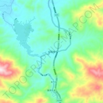
Name: 红庙镇 topographic map, elevation, terrain.
Location: 红庙镇, 南郑区, 汉中市, 陕西省, 中国 (32.82413 106.87435 32.90413 106.95435)
Average elevation: 2,595 ft
Minimum elevation: 1,946 ft
Maximum elevation: 4,354 ft
Make a donation
Gear up for your next adventure:
As an Amazon Associate, this site earns from qualifying purchases at no extra cost to you.
Other topographic maps
Click on a map to view its topography, its elevation and its terrain.
汉中市
北界秦岭山脉,南界大巴山,总面积27,246 km²。其间由汉江冲积形成汉中盆地。属凉亚热带气候。汉中市位于汉水上游,汉中盆地中部,东经106°51'-107°10'、北纬33°2'-33°22'之间。地形特点南低北高,市内有平坝、丘陵和山地等三种地貌,平坝为汉江冲积平原的一二阶梯,海拔500-600米之间,地势平坦,土壤肥沃,占全市面积的34.62%;丘陵为山前洪积扇形成的宽谷浅丘地带,海拔601-800米之间,地势起伏较大,约占全市面积的28.1%;山区是秦岭南坡形成的浅山和中山地区,地势较为复杂,土壤贫瘠,海拔在701-2038米之间,约占全市总面积的37.2%。
Average elevation: 3,822 ft
Make a donation
Gear up for your next adventure:
As an Amazon Associate, this site earns from qualifying purchases at no extra cost to you.
渭南市
渭南市是中华人民共和国陕西省下辖的地级市,位于陕西省东部,因地处渭河南岸而得名。市境北达延安市,西界铜川市、咸阳市、西安市,南邻商洛市,东接河南省三门峡市,并隔黄河与山西省运城市、临汾市相望。地处关中平原东部,地形以渭河冲积平原和黄土台塬为主,南部为秦岭山地,北部为北山山地。渭河横贯中部东流入黄河,北洛河自西北向东南斜贯注入渭河。全市总面积13,031平方公里,人口535.99万,市人民政府驻临渭区。渭南处于关中—天水经济区的最东端,是关中平原最宽阔的地带,也是中原地区通往中国西北地区的门户,被誉为“陕西东大门”,交通发达,素有“三秦要道,八省通衢”之称。
Average elevation: 2,894 ft
Make a donation
Gear up for your next adventure:
As an Amazon Associate, this site earns from qualifying purchases at no extra cost to you.
宝鸡市
宝鸡位于东经106°18′~108°03′和北纬33°35′~35°06′之间。东连咸阳,南接汉中,西北与甘肃省的天水和平凉毗邻。秦岭南屏,渭水中流,关陇西阻北横,渭北沃野平原。东西长156.6公里,南北宽160.6公里,总面积18117平方公里。宝鸡地质构造复杂,东、西、南、北、中的地貌差异大。具有南、西、北三面环山,只有东部敞开,大部分是丘陵地带。南部秦岭的主峰太白山是陕西最高点,海拔3767米。秦岭南边的河流属於长江水系,而北边是黄河水系。渭河是这里最大的河流,另外还有嘉陵江,千河,漆水河,石头河等。呈现“六山一水三分田”格局。
Average elevation: 4,590 ft
Make a donation
Gear up for your next adventure:
As an Amazon Associate, this site earns from qualifying purchases at no extra cost to you.
Make a donation
Gear up for your next adventure:
As an Amazon Associate, this site earns from qualifying purchases at no extra cost to you.
Make a donation
Gear up for your next adventure:
As an Amazon Associate, this site earns from qualifying purchases at no extra cost to you.
Make a donation
Gear up for your next adventure:
As an Amazon Associate, this site earns from qualifying purchases at no extra cost to you.
Make a donation
Gear up for your next adventure:
As an Amazon Associate, this site earns from qualifying purchases at no extra cost to you.
Make a donation
Gear up for your next adventure:
As an Amazon Associate, this site earns from qualifying purchases at no extra cost to you.
Make a donation
Gear up for your next adventure:
As an Amazon Associate, this site earns from qualifying purchases at no extra cost to you.
Make a donation
Gear up for your next adventure:
As an Amazon Associate, this site earns from qualifying purchases at no extra cost to you.
Make a donation
Gear up for your next adventure:
As an Amazon Associate, this site earns from qualifying purchases at no extra cost to you.
Make a donation
Gear up for your next adventure:
As an Amazon Associate, this site earns from qualifying purchases at no extra cost to you.
Make a donation
Gear up for your next adventure:
As an Amazon Associate, this site earns from qualifying purchases at no extra cost to you.
Make a donation
Gear up for your next adventure:
As an Amazon Associate, this site earns from qualifying purchases at no extra cost to you.
Make a donation
Gear up for your next adventure:
As an Amazon Associate, this site earns from qualifying purchases at no extra cost to you.
Make a donation
Gear up for your next adventure:
As an Amazon Associate, this site earns from qualifying purchases at no extra cost to you.
Make a donation
Gear up for your next adventure:
As an Amazon Associate, this site earns from qualifying purchases at no extra cost to you.
Make a donation
Gear up for your next adventure:
As an Amazon Associate, this site earns from qualifying purchases at no extra cost to you.
Make a donation
Gear up for your next adventure:
As an Amazon Associate, this site earns from qualifying purchases at no extra cost to you.
Make a donation
Gear up for your next adventure:
As an Amazon Associate, this site earns from qualifying purchases at no extra cost to you.
Make a donation
Gear up for your next adventure:
As an Amazon Associate, this site earns from qualifying purchases at no extra cost to you.
Make a donation
Gear up for your next adventure:
As an Amazon Associate, this site earns from qualifying purchases at no extra cost to you.
Make a donation
Gear up for your next adventure:
As an Amazon Associate, this site earns from qualifying purchases at no extra cost to you.
Make a donation
Gear up for your next adventure:
As an Amazon Associate, this site earns from qualifying purchases at no extra cost to you.
Make a donation
Gear up for your next adventure:
As an Amazon Associate, this site earns from qualifying purchases at no extra cost to you.