
Northern topographic map
Interactive map
Click on the map to display elevation.
About this map
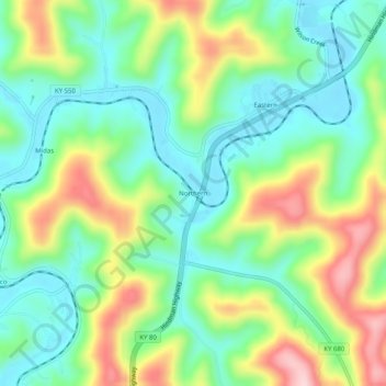
Name: Northern topographic map, elevation, terrain.
Location: Northern, Floyd County, Kentucky, 41622, United States (37.48788 -82.83544 37.52788 -82.79544)
Average elevation: 935 ft
Minimum elevation: 646 ft
Maximum elevation: 1,463 ft
Other topographic maps
Click on a map to view its topography, its elevation and its terrain.
Drift
United States > Kentucky > Floyd County
Drift, Floyd County, Kentucky, 41651, United States
Average elevation: 1,024 ft
David
United States > Kentucky > Floyd County
David, Floyd County, Kentucky, 41616, United States
Average elevation: 1,070 ft
Stanville
United States > Kentucky > Floyd County
Stanville, Floyd County, Kentucky, 41663, United States
Average elevation: 922 ft
Dwale
United States > Kentucky > Floyd County
Dwale, Floyd County, Kentucky, 41621, United States
Average elevation: 886 ft
Beaver
United States > Kentucky > Floyd County
Beaver, Floyd County, Kentucky, 41660, United States
Average elevation: 1,453 ft
Bypro
United States > Kentucky > Floyd County
Bypro, Floyd County, Kentucky, 41612, United States
Average elevation: 1,309 ft
Dana
United States > Kentucky > Floyd County
Dana, Floyd County, Kentucky, 41615, United States
Average elevation: 1,056 ft
Hi Hat
United States > Kentucky > Floyd County
Hi Hat, Floyd County, Kentucky, 41636, United States
Average elevation: 1,257 ft
Ivel
United States > Kentucky > Floyd County
Ivel, Floyd County, Kentucky, 41603, United States
Average elevation: 925 ft
Melvin
United States > Kentucky > Floyd County
Melvin, Floyd County, Kentucky, 41650, United States
Average elevation: 1,411 ft
Teaberry
United States > Kentucky > Floyd County
Teaberry, Floyd County, Kentucky, 41660, United States
Average elevation: 1,296 ft
Wheelwright
United States > Kentucky > Floyd County
Wheelwright, Floyd County, Kentucky, 41669, United States
Average elevation: 1,460 ft
Printer
United States > Kentucky > Floyd County
Printer, Floyd County, Kentucky, 41655, United States
Average elevation: 971 ft
Martin
United States > Kentucky > Floyd County
Martin, Floyd County, Kentucky, United States
Average elevation: 883 ft
Allen
United States > Kentucky > Floyd County
Allen, Floyd County, Kentucky, United States
Average elevation: 856 ft
Banner
United States > Kentucky > Floyd County
Banner, Floyd County, Kentucky, 41603, United States
Average elevation: 912 ft
Hueysville
United States > Kentucky > Floyd County
Hueysville, Floyd County, Kentucky, 41630, United States
Average elevation: 945 ft
Betsy Layne
United States > Kentucky > Floyd County
Betsy Layne, Floyd County, Kentucky, 41605, United States
Average elevation: 886 ft
Garrett
United States > Kentucky > Floyd County
Garrett, Floyd County, Kentucky, 41630, United States
Average elevation: 958 ft
McDowell
United States > Kentucky > Floyd County
McDowell, Floyd County, Kentucky, 41647, United States
Average elevation: 1,063 ft
Langley
United States > Kentucky > Floyd County
Langley, Floyd County, Kentucky, 41645, United States
Average elevation: 909 ft
Weeksbury
United States > Kentucky > Floyd County
Weeksbury, Floyd County, Kentucky, 41669, United States
Average elevation: 1,598 ft
Blue River
United States > Kentucky > Floyd County
Blue River, Floyd County, Kentucky, 41607, United States
Average elevation: 909 ft
Ligon
United States > Kentucky > Floyd County
Ligon, Floyd County, Kentucky, 41604, United States
Average elevation: 1,480 ft
Welco Station
United States > Kentucky > Floyd County
Welco Station, Floyd County, Kentucky, 41630, United States
Average elevation: 948 ft
Eastern
United States > Kentucky > Floyd County
Eastern, Floyd County, Kentucky, 41622, United States
Average elevation: 899 ft
Dema
United States > Kentucky > Floyd County
Dema, Floyd County, Kentucky, 41666, United States
Average elevation: 1,165 ft
Minnie
United States > Kentucky > Floyd County
Minnie, Floyd County, Kentucky, 41651, United States
Average elevation: 1,037 ft
Prestonsburg
United States > Kentucky > Floyd County > Prestonsburg > Prestonsburg
Prestonsburg, Floyd County, Kentucky, 41653, United States
Average elevation: 899 ft
Auxier
United States > Kentucky > Floyd County
Auxier, Floyd County, Kentucky, 41216, United States
Average elevation: 801 ft
Harold
United States > Kentucky > Floyd County
Harold, Floyd County, Kentucky, 41635, United States
Average elevation: 879 ft
Prestonsburg
United States > Kentucky > Floyd County
Prestonsburg, Floyd County, Kentucky, 41653, United States
Average elevation: 899 ft
Dewey Lake
United States > Kentucky > Floyd County > Prestonsburg
Dewey Lake, Prestonsburg, Floyd County, Kentucky, United States
Average elevation: 896 ft
Wayland
United States > Kentucky > Floyd County
Wayland, Floyd County, Kentucky, United States
Average elevation: 1,060 ft