
West Coast topographic map
Interactive map
Click on the map to display elevation.
About this map
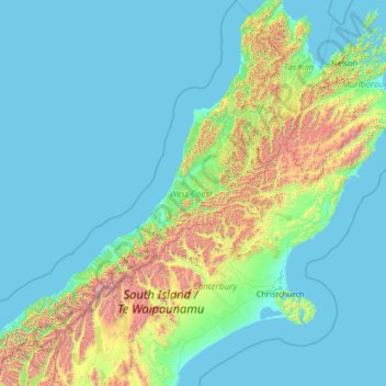
Name: West Coast topographic map, elevation, terrain.
Location: West Coast, New Zealand (-44.49907 167.83884 -40.62833 172.69210)
Average elevation: 1,027 ft
Minimum elevation: -3 ft
Maximum elevation: 11,342 ft
Other topographic maps
Click on a map to view its topography, its elevation and its terrain.
Moerewa
New Zealand > Northland > Far North District > Bay of Islands-Whangaroa Community
Average elevation: 292 ft
Naseby
New Zealand > Otago > Central Otago District
Naseby is a small town, formerly a borough, in the Maniototo area of Central Otago, New Zealand. It is named after a village in Northamptonshire, England, which was the site of a major battle during the English Civil War. Previous names of the township were Parker's, Hogburn and Mt Ida. The town catch phrase…
Average elevation: 2,031 ft
Taumarunui
New Zealand > Manawatu-Whanganui > Ruapehu District
Under the Köppen, Taumarunui has an Oceanic climate:(Cfb). Due to location, low altitude and Geography surroundings, Taumarunui is more liable to warm to hot summers than other central North Island centres and in winter, Taumarunui is cold and frosty. Rainfall yearly is 1,449 mm (57.047244 in). Annual…
Average elevation: 804 ft
Lake Roxburgh
New Zealand > Otago > Central Otago District > Teviot Valley Community
Average elevation: 692 ft
Taipa River
New Zealand > Northland > Far North District > Te Hiku Community > Cable Bay
Average elevation: 82 ft
Mount Cook
New Zealand > Canterbury > Mackenzie District
Aoraki / Mount Cook is the highest mountain in New Zealand. Its height, as of 2014, is listed as 3,724 metres (12,218 feet). It sits in the Southern Alps, the mountain range that runs the length of the South Island. A popular tourist destination, it is also a favourite challenge for mountain climbers. Aoraki /…
Average elevation: 9,580 ft
Queenstown
New Zealand > Otago > Queenstown-Lakes District
The town is at a relatively low altitude for a ski and snowboarding centre, at 310 metres (1,020 ft) above sea level at the lake shore, but is nestled among mountains, most notably the scenic attraction of The Remarkables, to the town's southeast. Below the lake lies the deep Kawarau Gorge, and there are…
Average elevation: 1,942 ft
Matakanui
New Zealand > Otago > Central Otago District > Vincent Community
Average elevation: 1,385 ft
Glenham
New Zealand > Southland > Southland District > Waihopai Toetoe Community
Average elevation: 358 ft
South Featherston
New Zealand > Wellington > South Wairarapa District > Featherston Community > Featherston
Average elevation: 85 ft
Sutherland Falls
New Zealand > Southland > Southland District > Fiordland Community
Average elevation: 3,301 ft
Ohinepaka Bay
New Zealand > Canterbury > Christchurch City > Banks Peninsula Community > Wainui
Average elevation: 308 ft
Central Otago
New Zealand > Otago > Central Otago District > Vincent Community
Average elevation: 3,068 ft
Shalamar Reserve
New Zealand > Canterbury > Christchurch City > Christchurch
Average elevation: 157 ft
Cape Kidnappers / Te Kauwae-a-Māui
New Zealand > Hawke's Bay > Hastings District
Average elevation: 52 ft
Zig Zag
New Zealand > Canterbury > Christchurch City > Banks Peninsula Community
Average elevation: 446 ft
Mount Mackenzie
New Zealand > Southland > Southland District > Fiordland Community
Average elevation: 3,839 ft
Oban
New Zealand > Southland > Southland District > Stewart Island / Rakiura Community
Average elevation: 75 ft