
Estill County topographic map
Interactive map
Click on the map to display elevation.
Estill County
Estill County contains two important rivers. With the Red River, famous for its gorge in neighboring Powell County, forming the northern border. And the Kentucky River bisecting the county. Much of Estill County's development, including the towns of Irvine and Ravenna, is located in the fertile bottomlands of the Kentucky River. Additionally, due to the Kentucky River's deep valley and Estill County's location at the edge of the Cumberland plateau the county's topography is striking. The Pottsville Escarpment is prominent in the county, marking the divide between the Bluegrass and the mountains. Because of this topography total relief is nearly 1000 feet in the county, with the highest point being Zion Mountain, located about 6+1⁄2 miles southwest of Irvine at 1,511 feet, and the lowest point being the confluence of the Kentucky River and the Red River at 566 feet. Other high points include Happy Top Mountain, 1,500 feet; Preacher Estes Mountain, 1,475 feet; Peter Mountain, 1,454 feet; Low Knob, 1,450 feet; and Big Round Mountain, Buzzard Roost, and McKinney Mountain, each at 1,420 feet. [1]
About this map
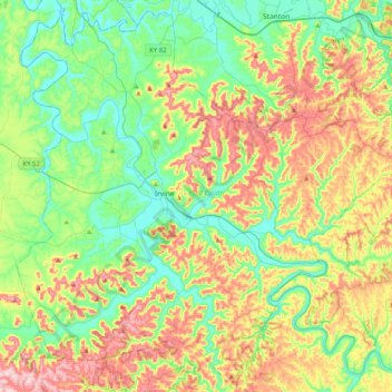
Name: Estill County topographic map, elevation, terrain.
Location: Estill County, Kentucky, United States (37.54287 -84.12695 37.85291 -83.72247)
Average elevation: 928 ft
Minimum elevation: 571 ft
Maximum elevation: 1,565 ft
Kentucky trails, hiking, mountain biking, running and outdoor activities
Other topographic maps
Click on a map to view its topography, its elevation and its terrain.
Jefferson Memorial Forest
United States > Kentucky > Jefferson County > Louisville
Average elevation: 538 ft
Black Mountain
United States > Kentucky > Harlan County
Black Mountain is the highest mountain peak in the Commonwealth of Kentucky, United States, with a summit elevation of 4,145 feet (1,263 m) above mean sea level and a top-to-bottom height of over 2,500 feet (760 m). The summit is located at approximately 36°54′51″N 82°53′38″W / 36.91417°N…
Average elevation: 3,635 ft
Pine Mountain State Resort Park
United States > Kentucky > Bell County > Pineville
Average elevation: 1,604 ft