Estill County topographic map
Interactive map
Click on the map to display elevation.
About this map
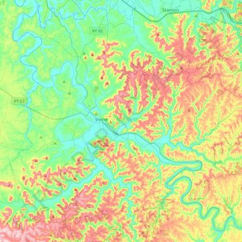
Name: Estill County topographic map, elevation, terrain.
Location: Estill County, Kentucky, United States (37.54319 -84.12708 37.85291 -83.72247)
Average elevation: 928 ft
Minimum elevation: 571 ft
Maximum elevation: 1,565 ft
Estill County contains two important rivers. With the Red River, famous for its gorge in neighboring Powell County, forming the northern border. And the Kentucky River bisecting the county. Much of Estill County's development, including the towns of Irvine and Ravenna, is located in the fertile bottomlands of the Kentucky River. Additionally, due to the Kentucky River's deep valley and Estill County's location at the edge of the Cumberland plateau the county's topography is striking. The Pottsville Escarpment is prominent in the county, marking the divide between the Bluegrass and the mountains. Because of this topography total relief is nearly 1000 feet in the county, with the highest point being Zion Mountain, located about 6+1⁄2 miles southwest of Irvine at 1,511 feet, and the lowest point being the confluence of the Kentucky River and the Red River at 566 feet. Other high points include Happy Top Mountain, 1,500 feet; Preacher Estes Mountain, 1,475 feet; Peter Mountain, 1,454 feet; Low Knob, 1,450 feet; and Big Round Mountain, Buzzard Roost, and McKinney Mountain, each at 1,420 feet. [1]
Other topographic maps
Click on a map to view its topography, its elevation and its terrain.
Louisville
United States > Kentucky > Jefferson County
Louisville, Jefferson County, Kentucky, United States
Average elevation: 617 ft
Owensboro
United States > Kentucky > Daviess County
Owensboro, Daviess County, Kentucky, United States
Average elevation: 404 ft
Paducah
United States > Kentucky > McCracken County
Paducah, McCracken County, Kentucky, United States
Average elevation: 354 ft
Bowling Green
United States > Kentucky > Warren County
Bowling Green, Warren County, Kentucky, 42101, United States
Average elevation: 554 ft
Newport
United States > Kentucky > Campbell County
Newport, Campbell County, Kentucky, 41071, United States
Average elevation: 568 ft
Somerset
United States > Kentucky > Pulaski County
Somerset, Pulaski County, Kentucky, 42503, United States
Average elevation: 968 ft
Pathfork
United States > Kentucky > Harlan County
Pathfork, Harlan County, Kentucky, 40863, United States
Average elevation: 1,752 ft
Lenarue
United States > Kentucky > Harlan County
Lenarue, Harlan County, Kentucky, 40818, United States
Average elevation: 1,703 ft
Lone Star
United States > Kentucky > Hart County
Lone Star, Hart County, Kentucky, 42713, United States
Average elevation: 748 ft
Sonora
United States > Kentucky > Hardin County
Sonora, Hardin County, Kentucky, United States
Average elevation: 725 ft
Load
United States > Kentucky > Greenup County
Load, Greenup County, Kentucky, United States
Average elevation: 728 ft
Hustonville
United States > Kentucky > Lincoln County
Hustonville, Lincoln County, Kentucky, United States
Average elevation: 1,037 ft
Bardo
United States > Kentucky > Harlan County
Bardo, Harlan County, Kentucky, 40830, United States
Average elevation: 2,080 ft
Holmes Mill
United States > Kentucky > Harlan County
Holmes Mill, Harlan County, Kentucky, 40843, United States
Average elevation: 2,487 ft
Putney
United States > Kentucky > Harlan County
Putney, Harlan County, Kentucky, 40865, United States
Average elevation: 1,972 ft
Uno
United States > Kentucky > Hart County
Uno, Hart County, Kentucky, United States
Average elevation: 659 ft
Frankfort
United States > Kentucky > Franklin County
Frankfort, Franklin County, Kentucky, United States
Average elevation: 709 ft
Inez
United States > Kentucky > Martin County
Inez, Martin County, Kentucky, 41224, United States
Average elevation: 830 ft
Elkhorn City
United States > Kentucky > Pike County
Elkhorn City, Pike County, Kentucky, United States
Average elevation: 1,194 ft
Walnut Hill
United States > Kentucky > Fayette County > Lexington
Walnut Hill, Lexington, Fayette County, Kentucky, 40509, United States
Average elevation: 1,020 ft
Paint Lick
United States > Kentucky > Garrard County
Paint Lick, Garrard County, Kentucky, 40461, United States
Average elevation: 892 ft
Sparrow
United States > Kentucky > Anderson County
Sparrow, Anderson County, Kentucky, United States
Average elevation: 755 ft
Pansy
United States > Kentucky > Harlan County
Pansy, Harlan County, Kentucky, 40830, United States
Average elevation: 1,975 ft
Boyd
United States > Kentucky > Harrison County
Boyd, Harrison County, Kentucky, 41003, United States
Average elevation: 702 ft
Hardyville
United States > Kentucky > Hart County
Hardyville, Hart County, Kentucky, United States
Average elevation: 696 ft
Alva
United States > Kentucky > Harlan County
Alva, Harlan County, Kentucky, 40863, United States
Average elevation: 2,139 ft
Leesburg
United States > Kentucky > Harrison County
Leesburg, Harrison County, Kentucky, United States
Average elevation: 919 ft
Frost
United States > Kentucky > Greenup County
Frost, Greenup County, Kentucky, 41175, United States
Average elevation: 591 ft
Saint John
United States > Kentucky > Hardin County
Saint John, Hardin County, Kentucky, 42724, United States
Average elevation: 778 ft
Nolin
United States > Kentucky > Hardin County
Nolin, Hardin County, Kentucky, 42740, United States
Average elevation: 689 ft
Wallins Creek
United States > Kentucky > Harlan County
Wallins Creek, Harlan County, Kentucky, United States
Average elevation: 1,365 ft
Lejunior
United States > Kentucky > Harlan County
Lejunior, Harlan County, Kentucky, 40865, United States
Average elevation: 1,919 ft
Pine Mountain
United States > Kentucky > Harlan County
Pine Mountain, Harlan County, Kentucky, United States
Average elevation: 1,759 ft
Three Point
United States > Kentucky > Harlan County
Three Point, Harlan County, Kentucky, 40815, United States
Average elevation: 1,558 ft
Louellen
United States > Kentucky > Harlan County
Louellen, Harlan County, Kentucky, 40849, United States
Average elevation: 2,290 ft
Jonesville
United States > Kentucky > Hart County
Jonesville, Hart County, Kentucky, 42757, United States
Average elevation: 791 ft
Kenvir
United States > Kentucky > Harlan County
Kenvir, Harlan County, Kentucky, 40847, United States
Average elevation: 2,106 ft
Ages
United States > Kentucky > Harlan County
Ages, Harlan County, Kentucky, 40801, United States
Average elevation: 1,926 ft
Fresh Meadows
United States > Kentucky > Harlan County
Fresh Meadows, Harlan County, Kentucky, 40824, United States
Average elevation: 1,516 ft
Yancey
United States > Kentucky > Harlan County
Yancey, Harlan County, Kentucky, 40830, United States
Average elevation: 2,136 ft
Broadwell
United States > Kentucky > Harrison County
Broadwell, Harrison County, Kentucky, United States
Average elevation: 866 ft
Wolf
United States > Kentucky > Carter County
Wolf, Carter County, Kentucky, United States
Average elevation: 889 ft
Howe Valley
United States > Kentucky > Hardin County
Howe Valley, Hardin County, Kentucky, United States
Average elevation: 725 ft
Hardin Springs
United States > Kentucky > Hardin County
Hardin Springs, Hardin County, Kentucky, 40145, United States
Average elevation: 640 ft
Hartford
United States > Kentucky > Ohio County
Hartford, Ohio County, Kentucky, United States
Average elevation: 404 ft
Limp
United States > Kentucky > Hardin County
Limp, Hardin County, Kentucky, United States
Average elevation: 692 ft
Big Laurel
United States > Kentucky > Harlan County
Big Laurel, Harlan County, Kentucky, 40808, United States
Average elevation: 1,883 ft
Cawood
United States > Kentucky > Harlan County
Cawood, Harlan County, Kentucky, 40818, United States
Average elevation: 1,634 ft
White Mills
United States > Kentucky > Hardin County
White Mills, Hardin County, Kentucky, 42788, United States
Average elevation: 640 ft