
Binh Duong Province topographic map
Interactive map
Click on the map to display elevation.
About this map
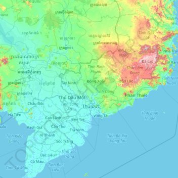
Name: Binh Duong Province topographic map, elevation, terrain.
Location: Binh Duong Province, Vietnam (8.59698 104.10805 13.79698 109.30805)
Average elevation: 397 ft
Minimum elevation: -10 ft
Maximum elevation: 6,857 ft
Other topographic maps
Click on a map to view its topography, its elevation and its terrain.
Bu Gia Map National Park
Vietnam > Bình Phước Province > Bù Gia Mập District
Average elevation: 1,385 ft
Southwest Cay
Vietnam > Khanh Hoa province > Trường Sa District > Xã Song Tử Tây
Average elevation: 0 ft
Hồ Sông Quao
Vietnam > Binh Thuan province > Hàm Thuận Bắc District > Xã Hàm Trí
Average elevation: 413 ft
Đồng Tháp Province
The topography of the province is quite flat with a sloping tendency from north to south and west to east, separating it into two large regions: one to the north of the Tiền River, having an area of 250,731 hectares (619,570 acres), in the Đồng Tháp Muoi area; and one to the south of the Tiền River,…
Average elevation: 10 ft
Hậu Giang Province
An estimated 80% of the province will be underwater following a 0.5 metres (1 ft 8 in) sea level rise relative to the current land elevation, which is subsiding over time.
Average elevation: 10 ft
Van Long Wetland Nature Reserve
Vietnam > Ninh Binh province > Gia Viễn District > Vân Long
Average elevation: 148 ft
Bắc Giang Province
The terrain is moderately mountainous, lying between the high mountains to the north and the Red River Delta to the south. Although a large part of the terrain is mountainous most of it is not isolated. The region to the northern end of the province is mountainous uncleared forest. To the east and southeast of…
Average elevation: 502 ft
Huế
Vietnam > Thừa Thiên Huế Province
Located near Truong Son mountain range, Hue city is a plain area in the lower reaches of the Perfume and Bo rivers, with an average altitude of 3–4 m above sea level and often flooded when the river's headwaters Huong has medium and large rainfall. This plain area is relatively flat, although there are…
Average elevation: 79 ft
Ben Cat Town
Ben Cat is in the transition zone from the Trường Sơn range in the north of the central highland to the southern plain, so the general topography of the whole town is relatively high from 30 to 35m above sea level in the north and lower to the south. In the south, the climate belongs to the tropical…
Average elevation: 82 ft
Tây Ninh Province
Tây Ninh has a tropical monsoon climate with two distinct seasons: a dry season from December to April and a rainy season from May to November. The temperature remains fairly consistent, with cooler and drier conditions in the early dry season and warmer, more humid weather in the rainy season. Daytime…
Average elevation: 75 ft
Tuyên Quang Province
The province has widely varying topography covering high mountains deep valleys; the dominant elevation of the province is in the range 200–600 metres (660–1,970 ft). The province is in the foothills of the Northern Highlands, which forms a broad crescent around the Tonkin Delta; its southern part has…
Average elevation: 1,043 ft
Đăk Nông Province
Đắk Nông is about 500m above sea level in elevation. The terrain is lower in the west. Đắk Nông has large fields and lakes in the south. Đắk Nông has three main river systems: the Ba River, the Srepok (or Sêrêpôk) river (part of the Mekong river basin) and Đồng Nai river demarking the…
Average elevation: 1,985 ft