
Make a donation
Gear up for your next adventure:
As an Amazon Associate, this site earns from qualifying purchases at no extra cost to you.
Grand Kru County topographic map
Click on the map to display elevation.
Make a donation
Gear up for your next adventure:
As an Amazon Associate, this site earns from qualifying purchases at no extra cost to you.
Grand Kru County
The residents have a subsistence farming economy, based on slash-and-burn techniques of clearing the bush. The most important crops are upland rice, cassava, palm nuts, and along the coast, fishing. Feed corn is grown at higher elevations farther inland. Sugar cane and several varieties of bananas grow in the wetland areas. Cash crops include coffee, cocoa and kola. Locally grown bamboo and piassava palm are widely used for construction, mats and baskets. Many tropical fruits, domestic and wild, grow in the region including oranges, limes, mangos, soursop, breadfruit and coconut.
Make a donation
Gear up for your next adventure:
As an Amazon Associate, this site earns from qualifying purchases at no extra cost to you.
About this map
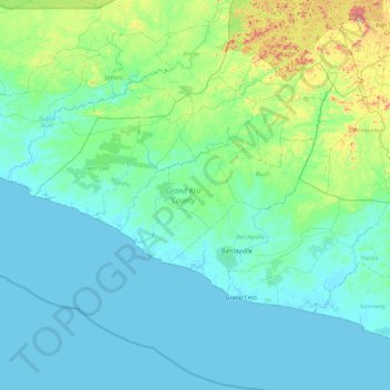
Name: Grand Kru County topographic map, elevation, terrain.
Location: Grand Kru County, Liberia (4.44853 -8.70903 5.17063 -7.79705)
Average elevation: 200 ft
Minimum elevation: -3 ft
Maximum elevation: 1,588 ft
Make a donation
Gear up for your next adventure:
As an Amazon Associate, this site earns from qualifying purchases at no extra cost to you.
Other topographic maps
Click on a map to view its topography, its elevation and its terrain.
Make a donation
Gear up for your next adventure:
As an Amazon Associate, this site earns from qualifying purchases at no extra cost to you.
Make a donation
Gear up for your next adventure:
As an Amazon Associate, this site earns from qualifying purchases at no extra cost to you.
Make a donation
Gear up for your next adventure:
As an Amazon Associate, this site earns from qualifying purchases at no extra cost to you.
Make a donation
Gear up for your next adventure:
As an Amazon Associate, this site earns from qualifying purchases at no extra cost to you.
Make a donation
Gear up for your next adventure:
As an Amazon Associate, this site earns from qualifying purchases at no extra cost to you.
Make a donation
Gear up for your next adventure:
As an Amazon Associate, this site earns from qualifying purchases at no extra cost to you.
Make a donation
Gear up for your next adventure:
As an Amazon Associate, this site earns from qualifying purchases at no extra cost to you.