
Santa Lucía topographic map
Click on the map to display elevation.
Santa Lucía
Santa Lucía se encuentra ubicado en las coordenadas 15°41′44″S 70°36′33″O / -15.69556, -70.60917. Según el INEI, Santa Lucía tiene 1595,67 km² y se encuentra situada en el sur de la Provincia de Lampa, en la zona central del departamento de Puno y en la parte sur del territorio peruano. Se halla a una altitud de 4.045 m s. n. m.
About this map
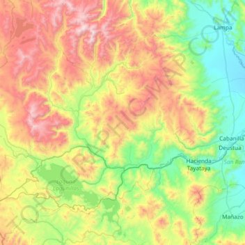
Name: Santa Lucía topographic map, elevation, terrain.
Location: Santa Lucía, Lampa, Puno, Perú (-15.85125 -71.03897 -15.31665 -70.45260)
Average elevation: 14,449 ft
Minimum elevation: 12,592 ft
Maximum elevation: 17,818 ft
Other topographic maps
Click on a map to view its topography, its elevation and its terrain.
La Rinconada
Situada en la alta montaña de los Andes, La Rinconada tiene un clima inusual y extremo, dada su condición de ciudad más alta del mundo por sus 5100 metros de altitud. Presenta un clima de tundra o frígido, de tipo alpino y muy próximo a considerarse clima gélido. La ciudad cuenta con una temperatura…
Average elevation: 16,152 ft
Puno
En 1734, se ve un asentamiento más consolidado en configuración, la bahía del lago Titicaca empieza a tomar importancia al originarse un puerto artesanal en lo que es hoy el muelle de la ciudad, por lo que Puno va creciendo hacia sus márgenes meridional y septentrional, la topografía de los cerros es otro…
Average elevation: 12,989 ft
Acora
Ácora es una localidad peruana capital del distrito homónimo ubicado en la provincia de Puno en el departamento de Puno. Se encuentra a una altitud de 3848 m s.n.m. Tenía 22 961 hab. según el censo de 2017. Está ubicada a 33km de la ciudad de Puno.
Average elevation: 12,635 ft
Allin Qhapaq
Allincapac es una montaña del Perú. Tiene una altitud de 5.807 m s. n. m. Forma parte de la Cordillera de Carabaya en los Andes. Se encuentra en el distrito de Macusani, provincia de Carabaya, departamento de Puno, Perú. Allincapac es acompañada por las montañas Huayna Cápac y Chichi Cápac. Aquí se…
Average elevation: 17,470 ft