
Darmstadt topographic map
Interactive map
Click on the map to display elevation.
About this map
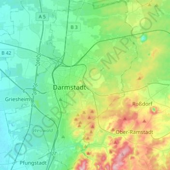
Name: Darmstadt topographic map, elevation, terrain.
Location: Darmstadt, Hesse, Germany (49.79567 8.55816 49.95380 8.74987)
Average elevation: 515 ft
Minimum elevation: 292 ft
Maximum elevation: 1,165 ft
Other topographic maps
Click on a map to view its topography, its elevation and its terrain.
65606
Germany > Hesse > Landkreis Limburg-Weilburg > Villmar
65606, Villmar, Landkreis Limburg-Weilburg, Hesse, Germany
Average elevation: 607 ft
Bergen-Enkheim
Bergen-Enkheim, Frankfurt, Hesse, 60388, Germany
Average elevation: 466 ft
Habitzheim
Germany > Hesse > Landkreis Darmstadt-Dieburg
Habitzheim, Otzberg, Landkreis Darmstadt-Dieburg, Hesse, Germany
Average elevation: 561 ft
Rüsselsheim am Main
Germany > Hesse > Kreis Groß-Gerau > Rüsselsheim am Main
Rüsselsheim am Main, Kreis Groß-Gerau, Hesse, 65428, Germany
Average elevation: 305 ft
Oberzell
Germany > Hesse > Main-Kinzig-Kreis
Oberzell, Sinntal, Main-Kinzig-Kreis, Hesse, Germany
Average elevation: 1,486 ft
Heiligenrode
Germany > Hesse > Landkreis Kassel
Heiligenrode, Niestetal, Landkreis Kassel, Hesse, 34266, Germany
Average elevation: 699 ft
Niedermeilingen
Germany > Hesse > Rheingau-Taunus-Kreis
Niedermeilingen, Heidenrod, Rheingau-Taunus-Kreis, Hesse, Germany
Average elevation: 1,211 ft
Kirchheim
Germany > Hesse > Landkreis Hersfeld-Rotenburg
Kirchheim, Landkreis Hersfeld-Rotenburg, Hesse, 36275, Germany
Average elevation: 1,171 ft
Wächtersbach
Germany > Hesse > Main-Kinzig-Kreis
Wächtersbach, Main-Kinzig-Kreis, Hesse, 63607, Germany
Average elevation: 774 ft
Hohenfels
Germany > Hesse > Landkreis Marburg-Biedenkopf > Buchenau
Hohenfels, Buchenau, Dautphetal, Landkreis Marburg-Biedenkopf, Hesse, 35232, Germany
Average elevation: 955 ft
Diemelstadt
Germany > Hesse > Landkreis Waldeck-Frankenberg
Diemelstadt, Landkreis Waldeck-Frankenberg, Hesse, 34474, Germany
Average elevation: 922 ft
Hochstadt
Germany > Hesse > Main-Kinzig-Kreis
Hochstadt, Maintal, Main-Kinzig-Kreis, Hesse, 63477, Germany
Average elevation: 446 ft
Korbach
Germany > Hesse > Landkreis Waldeck-Frankenberg
Korbach, Landkreis Waldeck-Frankenberg, Hesse, 34497, Germany
Average elevation: 1,276 ft
Wickenberg
Germany > Hesse > Werra-Meißner-Kreis > Bad Sooden-Allendorf
Wickenberg, Bad Sooden-Allendorf, Werra-Meißner-Kreis, Hesse, Germany
Average elevation: 1,355 ft
Karben
Germany > Hesse > Wetteraukreis
Karben, Wetteraukreis, Hesse, 61184, Germany
Average elevation: 463 ft
Flörsheim
Germany > Hesse > Main-Taunus-Kreis
Flörsheim, Main-Taunus-Kreis, Hesse, 65439, Germany
Average elevation: 364 ft
Taunusstein
Germany > Hesse > Rheingau-Taunus-Kreis
Taunusstein, Rheingau-Taunus-Kreis, Hesse, 65232, Germany
Average elevation: 1,286 ft
Nord (Holland)
Nord (Holland), Kassel, Hesse, 34109, Germany
Average elevation: 564 ft
Meißner
Germany > Hesse > Werra-Meißner-Kreis
Meißner, Werra-Meißner-Kreis, Hesse, 37290, Germany
Average elevation: 1,037 ft
Heusenstamm
Germany > Hesse > Landkreis Offenbach
Heusenstamm, Landkreis Offenbach, Hesse, 63150, Germany
Average elevation: 436 ft
Beerfelden
Germany > Hesse > Odenwaldkreis > Beerfelden
Beerfelden, Oberzent, Odenwaldkreis, Hesse, 64760, Germany
Average elevation: 1,325 ft
Lauterbach
Germany > Hesse > Vogelsbergkreis
Lauterbach, Vogelsbergkreis, Hesse, 36341, Germany
Average elevation: 1,184 ft
Witzenhausen
Germany > Hesse > Werra-Meißner-Kreis
Witzenhausen, Werra-Meißner-Kreis, Hesse, Germany
Average elevation: 974 ft
Michelstadt
Germany > Hesse > Odenwaldkreis
Michelstadt, Odenwaldkreis, Hesse, 64720, Germany
Average elevation: 1,175 ft
Rasdorf
Germany > Hesse > Landkreis Fulda
Rasdorf, Landkreis Fulda, Hesse, 36169, Germany
Average elevation: 1,188 ft
Main
Germany > Hesse > Kreis Groß-Gerau > Bischofsheim
Main, Bischofsheim, Kreis Groß-Gerau, Hesse, Germany
Average elevation: 325 ft
Oberzent
Germany > Hesse > Odenwaldkreis
Oberzent, Odenwaldkreis, Hesse, 64760, Germany
Average elevation: 1,302 ft
Oberems
Germany > Hesse > Hochtaunuskreis
Oberems, Glashütten, Hochtaunuskreis, Hesse, Germany
Average elevation: 1,575 ft
Limburg an der Lahn
Germany > Hesse > Landkreis Limburg-Weilburg > Limburg an der Lahn
Limburg an der Lahn, Landkreis Limburg-Weilburg, Hesse, Germany
Average elevation: 581 ft
Maintal
Germany > Hesse > Main-Kinzig-Kreis
Maintal, Main-Kinzig-Kreis, Hesse, 63477, Germany
Average elevation: 410 ft
Oestrich-Winkel
Germany > Hesse > Rheingau-Taunus-Kreis > Oestrich-Winkel
Oestrich-Winkel, Rheingau-Taunus-Kreis, Hesse, 65375, Germany
Average elevation: 981 ft
Friedrichsdorf
Germany > Hesse > Friedrichsdorf
Friedrichsdorf, Hochtaunuskreis, Hesse, 61381, Germany
Average elevation: 741 ft
Schmitten
Germany > Hesse > Hochtaunuskreis > Schmitten
Schmitten, Schmitten im Taunus, Hochtaunuskreis, Hesse, 61389, Germany
Average elevation: 1,752 ft
Reichenbach
Germany > Hesse > Kreis Bergstraße > Lautertal
Reichenbach, Lautertal, Kreis Bergstraße, Hesse, 64686, Germany
Average elevation: 1,030 ft
Hochheim
Germany > Hesse > Main-Taunus-Kreis
Hochheim, Main-Taunus-Kreis, Hesse, 65239, Germany
Average elevation: 404 ft
Braunfels
Germany > Hesse > Lahn-Dill-Kreis
Braunfels, Lahn-Dill-Kreis, Hesse, Germany
Average elevation: 794 ft
Idstein
Germany > Hesse > Rheingau-Taunus-Kreis > Idstein
Idstein, Rheingau-Taunus-Kreis, Hesse, 65510, Germany
Average elevation: 1,161 ft
Fränkisch-Crumbach
Germany > Hesse > Fränkisch-Crumbach
Fränkisch-Crumbach, Odenwaldkreis, Hesse, 64407, Germany
Average elevation: 801 ft
Hofheim am Taunus
Germany > Hesse > Main-Taunus-Kreis > Hofheim am Taunus
Hofheim am Taunus, Main-Taunus-Kreis, Hesse, 65719, Germany
Average elevation: 650 ft
Cölbe
Germany > Hesse > Landkreis Marburg-Biedenkopf > Cölbe
Cölbe, Landkreis Marburg-Biedenkopf, Hesse, 35091, Germany
Average elevation: 804 ft
Grebenstein
Germany > Hesse > Grebenstein
Grebenstein, Landkreis Kassel, Hesse, 34393, Germany
Average elevation: 745 ft
Edersee
Germany > Hesse > Landkreis Waldeck-Frankenberg > Hemfurth-Edersee
Edersee, Hemfurth-Edersee, Edertal, Landkreis Waldeck-Frankenberg, Hesse, Germany
Average elevation: 1,145 ft