
Make a donation
Gear up for your next adventure:
As an Amazon Associate, this site earns from qualifying purchases at no extra cost to you.
Baltimore topographic map
Click on the map to display elevation.
Make a donation
Gear up for your next adventure:
As an Amazon Associate, this site earns from qualifying purchases at no extra cost to you.
Baltimore
Baltimore exhibits a diverse topography that plays a significant role in its character and development. Situated along the Patapsco River, which flows into the Chesapeake Bay, the city is positioned on the fall line that separates the Piedmont Plateau to the west from the Atlantic Coastal Plain to the east. This geographic setting results in varying elevations, with the harbor area at sea level and some neighborhoods reaching heights of approximately 480 feet (150 meters) in the northwest, particularly near Pimlico. The terrain features rolling hills and valleys, contributing to the city's scenic vistas and the fertile land that supports urban green spaces. Overall, Baltimore's topography combines urban development with natural landscapes, creating a unique environment that reflects both its historical significance and modern character.
Make a donation
Gear up for your next adventure:
As an Amazon Associate, this site earns from qualifying purchases at no extra cost to you.
About this map
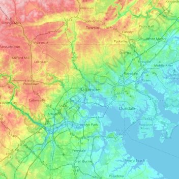
Name: Baltimore topographic map, elevation, terrain.
Location: Baltimore, Maryland, 21233, United States (39.13088 -76.77076 39.45088 -76.45076)
Average elevation: 213 ft
Minimum elevation: -16 ft
Maximum elevation: 719 ft
Maryland trails, hiking, mountain biking, running and outdoor activities
Make a donation
Gear up for your next adventure:
As an Amazon Associate, this site earns from qualifying purchases at no extra cost to you.
Other topographic maps
Click on a map to view its topography, its elevation and its terrain.
Chesapeake Bay
Tides in the Chesapeake Bay exhibit an interesting and unique behavior due to the nature of the topography (both horizontal and vertical shape), wind-driven circulation, and how the Bay interacts with oceanic tides. Research into the peculiar behavior of tides both at the northern and southern extents of the…
Average elevation: 108 ft
Worcester County
The terrain is mostly level and coastal. The lowest elevation is sea level along the Atlantic Ocean and the highest elevation is 49 ft (15 m) in the northwestern part of the county along State Route 12 just south of the Wicomico County line.
Average elevation: 20 ft
Make a donation
Gear up for your next adventure:
As an Amazon Associate, this site earns from qualifying purchases at no extra cost to you.
Deep Creek Lake Natural Resource Management Area
United States > Maryland > Garrett County > McHenry
Average elevation: 2,602 ft
Make a donation
Gear up for your next adventure:
As an Amazon Associate, this site earns from qualifying purchases at no extra cost to you.
Make a donation
Gear up for your next adventure:
As an Amazon Associate, this site earns from qualifying purchases at no extra cost to you.
Make a donation
Gear up for your next adventure:
As an Amazon Associate, this site earns from qualifying purchases at no extra cost to you.
Darlington
United States > Maryland > Harford County > Darlington > Hopkins Corner
Average elevation: 289 ft
Wicomico County
The county's boundary with Delaware is composed of the Mason-Dixon line and the Transpeninsular Line. The intersection of these two historical lines is the midpoint of the Transpeninsular Line, fixed by Mason and Dixon between 1763 and 1767. The midpoint is located about 8 miles (13 km) northwest of Salisbury,…
Average elevation: 30 ft
Make a donation
Gear up for your next adventure:
As an Amazon Associate, this site earns from qualifying purchases at no extra cost to you.
Rawlings
United States > Maryland > Allegany County > Rawlings > Rawlings Heights
Average elevation: 860 ft
Make a donation
Gear up for your next adventure:
As an Amazon Associate, this site earns from qualifying purchases at no extra cost to you.
Crisfield
United States > Maryland > Somerset County
Crisfield is a very compact city, with little vacant land. According to the United States Census Bureau, the city has a total area of 3.06 square miles (7.93 km2), of which 1.62 square miles (4.20 km2) (53.0%) is land and 1.44 square miles (3.73 km2) (47.0%) is water. As one of the southern points on the…
Average elevation: 3 ft
Make a donation
Gear up for your next adventure:
As an Amazon Associate, this site earns from qualifying purchases at no extra cost to you.
Make a donation
Gear up for your next adventure:
As an Amazon Associate, this site earns from qualifying purchases at no extra cost to you.
Make a donation
Gear up for your next adventure:
As an Amazon Associate, this site earns from qualifying purchases at no extra cost to you.
Patapsco Valley State Park
United States > Maryland > Howard County > Ilchester
Average elevation: 430 ft
Make a donation
Gear up for your next adventure:
As an Amazon Associate, this site earns from qualifying purchases at no extra cost to you.
Snow Hill
United States > Maryland > Worcester County
Snow Hill was founded in 1686 in Somerset County by English settlers, who may have named it after a street and neighborhood of the City of London called "Snow Hill", despite the location's elevation of just 16 feet (4.9 m) above sea level and the infrequency of snowfall. The town received its first charter on…
Average elevation: 23 ft
Make a donation
Gear up for your next adventure:
As an Amazon Associate, this site earns from qualifying purchases at no extra cost to you.
Make a donation
Gear up for your next adventure:
As an Amazon Associate, this site earns from qualifying purchases at no extra cost to you.
Make a donation
Gear up for your next adventure:
As an Amazon Associate, this site earns from qualifying purchases at no extra cost to you.
Rosaryville State Park
United States > Maryland > Prince George's County > Upper Marlboro
Average elevation: 194 ft
Make a donation
Gear up for your next adventure:
As an Amazon Associate, this site earns from qualifying purchases at no extra cost to you.
Make a donation
Gear up for your next adventure:
As an Amazon Associate, this site earns from qualifying purchases at no extra cost to you.
Shaft
United States > Maryland > Allegany County > Borden Shaft > Braddock Estates
Shaft is a census-designated place (CDP) corresponding to the unincorporated community of Borden Shaft in Allegany County, Maryland, United States. As of the 2010 census, the CDP had a population of 235. It is located south of Frostburg, in the Georges Creek Valley. It lies at an elevation of 1,795 feet (547…
Average elevation: 1,929 ft
Make a donation
Gear up for your next adventure:
As an Amazon Associate, this site earns from qualifying purchases at no extra cost to you.
Make a donation
Gear up for your next adventure:
As an Amazon Associate, this site earns from qualifying purchases at no extra cost to you.
Assateague Island National Seashore
United States > Maryland > Worcester County > West Ocean City
Average elevation: 7 ft
Make a donation
Gear up for your next adventure:
As an Amazon Associate, this site earns from qualifying purchases at no extra cost to you.
Lavale Community Park
United States > Maryland > Allegany County > Allegany Grove
Average elevation: 1,161 ft
Make a donation
Gear up for your next adventure:
As an Amazon Associate, this site earns from qualifying purchases at no extra cost to you.
Darnestown
United States > Maryland > Montgomery County
In the 2000 census, the Census Bureau created a new Census-designated place (CDP) called Darnestown. A Darnestown CDP was also used in the 2010 census. The Darnestown CDP has 16.39 square miles (42.4 km2) of land, which is smaller than the old Darnestown MCD. The CDP uses the Muddy Branch, Turkey Foot Road,…
Average elevation: 318 ft
Avondale Wildlife Management Area
United States > Maryland > Carroll County > Chapel Heights
Average elevation: 676 ft
Make a donation
Gear up for your next adventure:
As an Amazon Associate, this site earns from qualifying purchases at no extra cost to you.
Paramount-Long Meadow
United States > Maryland > Washington County > Paramount
Average elevation: 581 ft
Make a donation
Gear up for your next adventure:
As an Amazon Associate, this site earns from qualifying purchases at no extra cost to you.
Franklin Point State Park
United States > Maryland > Anne Arundel County > Columbia Beach
Average elevation: 3 ft
Make a donation
Gear up for your next adventure:
As an Amazon Associate, this site earns from qualifying purchases at no extra cost to you.
Cape St. Claire
United States > Maryland > Anne Arundel County > Cape Saint Claire
Average elevation: 39 ft
Make a donation
Gear up for your next adventure:
As an Amazon Associate, this site earns from qualifying purchases at no extra cost to you.
Assateague State Park
United States > Maryland > Worcester County > Berlin > Golf Club Shores
Average elevation: 3 ft
Make a donation
Gear up for your next adventure:
As an Amazon Associate, this site earns from qualifying purchases at no extra cost to you.
Chapman State Park
United States > Maryland > Charles County > Indian Head > Chapman Landing
Average elevation: 62 ft
Soldiers Delight Natural Environment Area
United States > Maryland > Baltimore County > Owings Mills
Average elevation: 614 ft
Make a donation
Gear up for your next adventure:
As an Amazon Associate, this site earns from qualifying purchases at no extra cost to you.