
Harrison County topographic map
Interactive map
Click on the map to display elevation.
About this map
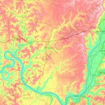
Name: Harrison County topographic map, elevation, terrain.
Location: Harrison County, Indiana, United States (37.95869 -86.33109 38.42269 -85.89961)
Average elevation: 673 ft
Minimum elevation: 377 ft
Maximum elevation: 1,010 ft
Indiana trails, hiking, mountain biking, running and outdoor activities
Other topographic maps
Click on a map to view its topography, its elevation and its terrain.
Indianapolis
United States > Indiana > Indianapolis
Indianapolis is within the Tipton Till Plain, a flat to gently sloping terrain underlain by glacial deposits known as till. The lowest point in the city is about 650 feet (198 m) above mean sea level, with the highest natural elevation at about 900 feet (274 m) above sea level. Few hills or short ridges, known…
Average elevation: 791 ft
Brown County State Park
United States > Indiana > Nashville
Brown County State Park is sometimes called "the Little Smokies" because of similarities with the Smokey Mountains. Activities available in the park include camping, fishing, biking, hiking, and seasonal horseback riding. Many of these activities are available all year. Overnight visitors may stay in the…
Average elevation: 735 ft
Clifty Falls State Park
United States > Indiana > Jefferson County > Madison
Average elevation: 787 ft
Starve Hollow State Recreation Area
United States > Indiana > Jackson County
Average elevation: 614 ft
White River
United States > Indiana > Marion County > Indianapolis > Ravenswood
Average elevation: 745 ft