
Make a donation
Gear up for your next adventure:
As an Amazon Associate, this site earns from qualifying purchases at no extra cost to you.
Democratic Republic of the Congo topographic map
Click on the map to display elevation.
Make a donation
Gear up for your next adventure:
As an Amazon Associate, this site earns from qualifying purchases at no extra cost to you.
Democratic Republic of the Congo
The tropical climate produced the Congo River system which dominates the region topographically along with the rainforest it flows through. The Congo Basin occupies nearly the entire country and an area of nearly 1,000,000 km2 (390,000 sq mi). The river and its tributaries form the backbone of Congolese economics and transportation. Major tributaries include the Kasai, Sangha, Ubangi, Ruzizi, Aruwimi, and Lulonga.
Make a donation
Gear up for your next adventure:
As an Amazon Associate, this site earns from qualifying purchases at no extra cost to you.
About this map
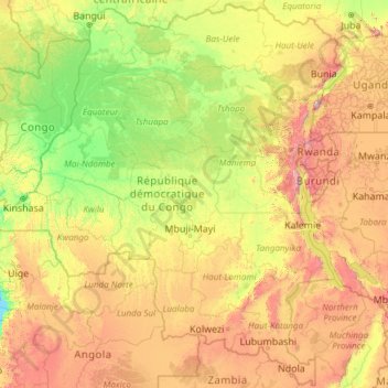
Name: Democratic Republic of the Congo topographic map, elevation, terrain.
Location: Democratic Republic of the Congo (-13.45904 12.03907 5.39200 31.30568)
Average elevation: 2,753 ft
Minimum elevation: 705 ft
Maximum elevation: 14,019 ft
Make a donation
Gear up for your next adventure:
As an Amazon Associate, this site earns from qualifying purchases at no extra cost to you.
Other topographic maps
Click on a map to view its topography, its elevation and its terrain.
Africa
Africa's topography is a complex tapestry of plateaus, mountains, valleys, and deserts. The continent is dominated by vast plateaus, with elevations averaging around 1,000 meters (3,281 feet), especially prominent in the south and east. The Ethiopian Highlands, often referred to as the "Roof of Africa," rise…
Average elevation: 1,516 ft
Columbia
United States of America > Maryland > Columbia
The primary landforms in Columbia are rolling hills and stream valleys; Columbia's road network is laid out to follow the terrain, with many winding streets and cul-de-sacs. Elevations range from about 200 to 500 feet (61 to 152 m) above sea level. Most of Columbia is drained by the Middle Patuxent and Little…
Average elevation: 361 ft
San Francisco Bay Area
United States > California > San Francisco
The San Francisco Bay Area is characterized by a diverse and dynamic topography shaped by geological processes over millions of years. This region features a combination of coastal plains, steep hills, and rugged mountains, all influenced by the tectonic activity associated with the nearby San Andreas Fault…
Average elevation: 371 ft
Make a donation
Gear up for your next adventure:
As an Amazon Associate, this site earns from qualifying purchases at no extra cost to you.
Appalachian Mountains
United States > North Carolina > Yancey County
The Appalachian Mountains (French: Appalaches), often called the Appalachians, are a system of mountains in eastern to northeastern North America. The Appalachians first formed roughly 480 million years ago during the Ordovician Period. They once reached elevations similar to those of the Alps and the Rocky…
Average elevation: 4,800 ft
South America
South America's topography is marked by remarkable diversity and dramatic contrasts. The continent is dominated by the Andes mountain range, which runs along its western edge, stretching over 4,300 miles from Venezuela to Chile. These mountains are home to some of the highest peaks in the Western Hemisphere,…
Average elevation: 928 ft
Flagstaff
United States > Arizona > Coconino County
Flagstaff, located in Coconino County, Arizona, is characterized by its diverse topography, primarily shaped by its high elevation and volcanic activity. Sitting at around 7,000 feet (approximately 2,130 meters), the city is surrounded by the expansive Coconino National Forest, which features a blend of…
Average elevation: 7,139 ft
Alun-Alun Ambarawa
Indonesia > Central Java > Kabupaten Semarang > Tambakboyo > Katang
Average elevation: 1,637 ft
Make a donation
Gear up for your next adventure:
As an Amazon Associate, this site earns from qualifying purchases at no extra cost to you.
Make a donation
Gear up for your next adventure:
As an Amazon Associate, this site earns from qualifying purchases at no extra cost to you.
Tucson
United States > Arizona > Pima County > Tucson
The city's elevation is 2,643 ft (806 m) above sea level (as measured at the Tucson International Airport). Tucson is on an alluvial plain in the Sonoran Desert, surrounded by five minor ranges of mountains: the Santa Catalina Mountains and the Tortolita Mountains to the north, the Santa Rita Mountains to the…
Average elevation: 2,743 ft
Make a donation
Gear up for your next adventure:
As an Amazon Associate, this site earns from qualifying purchases at no extra cost to you.
Atlanta
United States > Georgia > Fulton County
Atlanta (/ætˈlæntə/ at-LAN-tə) is the capital and most populous city of the U.S. state of Georgia. It is the seat of Fulton County, the most populous county in Georgia. With a population of 498,715 living within the city limits, it is the eighth most populous city in the Southeast and 38th most populous…
Average elevation: 935 ft
Make a donation
Gear up for your next adventure:
As an Amazon Associate, this site earns from qualifying purchases at no extra cost to you.
Boise
United States > Idaho > Ada County
Boise (locally /ˈbɔɪsi/ BOY-see) is the capital and most populous city of the U.S. state of Idaho and is the county seat of Ada County. As of the 2020 census, there were 235,684 people residing in the city. On the Boise River in southwestern Idaho, it is 41 miles (66 km) east of the Oregon border and 110…
Average elevation: 3,412 ft
Make a donation
Gear up for your next adventure:
As an Amazon Associate, this site earns from qualifying purchases at no extra cost to you.
Mauna Kea
United States > Hawaii > Hawaiʻi County
Mauna Kea (/ˌmaʊnə ˈkeɪə/; Hawaiian: [ˈmɐwnə ˈkɛjə]; abbreviation for Mauna a Wākea) is a dormant volcano on the island of Hawaiʻi. Its peak is 4,207.3 m (13,803 ft) above sea level, making it the highest point in the state of Hawaiʻi and second-highest peak of an island on Earth. The peak is…
Average elevation: 13,051 ft
Himalayas
Nepal > Koshi Province > Solukhumbu
The Himalayas present a dramatic and varied topography characterized by towering peaks, deep valleys, and extensive glaciers. This majestic mountain range features some of the highest elevations on Earth, including Mount Everest, which rises to 29,035 feet. The terrain is marked by steep, jagged ridges and…
Average elevation: 24,787 ft
City of London
United Kingdom > England > City of London > City of London
The elevation of the City ranges from sea level at the Thames to 21.6 metres (71 ft) at the junction of High Holborn and Chancery Lane. Two small but notable hills are within the historic core, Ludgate Hill to the west and Cornhill to the east. Between them ran the Walbrook, one of the many "lost" rivers or…
Average elevation: 138 ft
North America
North America's topography is characterized by its diverse and dramatic landscapes, stretching from the towering Rocky Mountains in the west to the expansive Great Plains in the central region, and the rugged Appalachian Mountains in the east. The Rocky Mountains, which include peaks exceeding 20,000 feet…
Average elevation: 965 ft
Make a donation
Gear up for your next adventure:
As an Amazon Associate, this site earns from qualifying purchases at no extra cost to you.
Placerville
United States > California > Placerville
The region east of Placerville, popularly known as Apple Hill and Pleasant Valley, is becoming a center for wine production. The wine region is officially designated as the El Dorado AVA. The largest wineries in the area are Boeger, Lava Cap and Madrona, but most of the 30 plus wineries surrounding Placerville…
Average elevation: 1,926 ft
Make a donation
Gear up for your next adventure:
As an Amazon Associate, this site earns from qualifying purchases at no extra cost to you.
Make a donation
Gear up for your next adventure:
As an Amazon Associate, this site earns from qualifying purchases at no extra cost to you.
Make a donation
Gear up for your next adventure:
As an Amazon Associate, this site earns from qualifying purchases at no extra cost to you.
Make a donation
Gear up for your next adventure:
As an Amazon Associate, this site earns from qualifying purchases at no extra cost to you.
Gran Chaco
Paraguay > Alto Paraguay > Bahía Negra
Large tracts of the central and northern Chaco have high soil fertility, sandy alluvial soils with elevated levels of phosphorus, and a topography that is favorable for agricultural development. Other aspects are challenging for farming: a semiarid to semihumid climate (600–1300 mm annual rainfall) with a…
Average elevation: 545 ft
Kveda Tkhilvana
Georgia > Autonomous Republic of Adjara > Khulo Municipality
Average elevation: 5,364 ft
Make a donation
Gear up for your next adventure:
As an Amazon Associate, this site earns from qualifying purchases at no extra cost to you.
Aluva
Aluva Railway Station (IR Code: AWY) is a grade-A station and the third busiest in Kochi after Ernakulam Junction railway station and Ernakulam Town railway station. Every passenger and express train bound for southern Kerala stops here. Travelers from the Idukki district typically use either the Aluva or the…
Average elevation: 36 ft
Make a donation
Gear up for your next adventure:
As an Amazon Associate, this site earns from qualifying purchases at no extra cost to you.
Austria
According to the Köppen Climate Classification Austria has the following climate types: Oceanic (Cfb), Cool/Warm-summer humid continental (Dfb), Subarctic/Subalpine (Dfc), Tundra/Alpine (ET), and Ice-Cap (EF). It is important to note though that Austria may experience very cold, severe winters, but most of…
Average elevation: 1,096 ft
Anna Maria island
United States > Florida > Manatee County
Anna Maria Island features a flat, sandy topography typical of a barrier island on the Gulf Coast. With an average elevation of around 15 feet above sea level, the terrain includes broad beaches, low dunes, and narrow stretches of sandy soil, making it highly vulnerable to storm surges and tidal flooding. The…
Average elevation: 7 ft
East Texas
United States > Pennsylvania > Lehigh County > Lower Macungie Township
Average elevation: 413 ft
Make a donation
Gear up for your next adventure:
As an Amazon Associate, this site earns from qualifying purchases at no extra cost to you.
Largo
United States > Florida > Pinellas County > Largo
In 2010, Largo's total area was 18.6 square miles (48.1 km2), of which 17.6 square miles (45.6 km2) was land and 0.97 square miles (2.5 km2), or 5.22%, was water. As of 2004, there were 651 acres (2.6 km2) of park lands. The city's lowest elevation is sea level. At its highest, the city's elevation is about 69…
Average elevation: 16 ft
Englewood
United States > Florida > Sarasota County
Englewood features predominantly flat and low-lying terrain typical of the region's coastal landscape. The average elevation here is approximately 15 feet above sea level, which makes the area particularly susceptible to tidal influences and storm surges. The terrain is interspersed with wetlands and…
Average elevation: 10 ft
Make a donation
Gear up for your next adventure:
As an Amazon Associate, this site earns from qualifying purchases at no extra cost to you.
Washington, D.C.
United States of America > Washington, D.C. > Washington, D.C.
The highest natural elevation in the District is 409 feet (125 m) above sea level at Fort Reno Park in upper northwest Washington. The lowest point is sea level at the Potomac River. The geographic center of Washington is near the intersection of 4th and L Streets NW.
Average elevation: 207 ft
Make a donation
Gear up for your next adventure:
As an Amazon Associate, this site earns from qualifying purchases at no extra cost to you.
Fraser
United States > Colorado > Grand County
Fraser is located in southeastern Grand County at 39°56′39″N 105°48′48″W / 39.94417°N 105.81333°W / 39.94417; -105.81333 (39.944158, -105.813355), at an elevation of 8,574 feet (2,613 m) above sea level. It is bordered to the south by the town of Winter Park and to the north by…
Average elevation: 8,845 ft
Santiago
Chile > Santiago Metropolitan Region > Provincia de Santiago
The city lies in the center of the Santiago Basin, a large bowl-shaped valley consisting of broad and fertile lands surrounded by mountains. The city has a varying elevation, gradually increasing from 400 m (1,312 ft) in the western areas to more than 700 m (2,297 ft) in the eastern areas. Santiago's…
Average elevation: 2,369 ft
Monterrey
Mexico > Nuevo León > Monterrey
The city of Monterrey is 540 metres (1,770 ft) above sea level in the northeastern state of Nuevo León. Monterrey translated literally from Spanish to English is "King Mount" or "King Mountain", and folk etymology claims that this refers to the city's topography and the large mountains that surround it…
Average elevation: 2,470 ft
Santa Cruz Mountains
United States > California > Santa Clara County
The Santa Cruz Mountains are a region of great biological diversity, encompassing cool, moist coastal ecosystems as well as warm, dry chaparral. Much of the area in the Santa Cruz mountains is considered temperate rainforest. In valleys and moist ocean-facing slopes some of the southernmost coast redwoods…
Average elevation: 755 ft
Make a donation
Gear up for your next adventure:
As an Amazon Associate, this site earns from qualifying purchases at no extra cost to you.
Grand Canyon
United States > Arizona > Coconino County
Uplift associated with mountain formation later moved these sediments thousands of feet upward and created the Colorado Plateau. The higher elevation has also resulted in greater precipitation in the Colorado River drainage area, but not enough to change the Grand Canyon area from being semi-arid. The uplift…
Average elevation: 3,356 ft
Scottish Highlands
United Kingdom > Scotland > Highland
The Scottish Highlands are renowned for their rugged, mountainous terrain that dominates much of the region. Stretching across the northern and central parts of Scotland, the landscape is shaped by ancient geological forces, including the Caledonian Orogeny, which caused significant tectonic collisions…
Average elevation: 2,976 ft
Make a donation
Gear up for your next adventure:
As an Amazon Associate, this site earns from qualifying purchases at no extra cost to you.
La Jolla
United States > California > San Diego County > San Diego > La Jolla
Average elevation: 121 ft
Make a donation
Gear up for your next adventure:
As an Amazon Associate, this site earns from qualifying purchases at no extra cost to you.
Europe
Europe's topography is characterized by a striking contrast between its rugged southern mountains and the expansive plains of the north. The continent is often described as a "peninsula of peninsulas," featuring major peninsulas like the Iberian, Italian, and Balkan, each with unique geological features. In…
Average elevation: 732 ft
Sarajevo
Bosnia and Herzegovina > Federation of Bosnia and Herzegovina > Sarajevo
Average elevation: 3,117 ft
Make a donation
Gear up for your next adventure:
As an Amazon Associate, this site earns from qualifying purchases at no extra cost to you.
Menifee
United States > California > Riverside County
Menifee is a city in Riverside County, California, United States, and part of the Los Angeles Combined Statistical Area. The city is centrally located in Southern California in the Menifee Valley. It is almost 15 miles (24 km) north of Temecula and just north of Murrieta. Menifee is roughly 46 square miles…
Average elevation: 1,496 ft
Troy
United States > New York > Rensselaer County
The western edge of the city is flat along the river, and then steeply slopes to higher terrain to the east. The average elevation is 50 feet, with the highest elevation being 500 feet in the eastern part of the city. The city is longer than it is wide, with the southern part wider than the northern section of…
Average elevation: 449 ft
Tijuana
Mexico > Baja California > Municipio de Tijuana
Housing development in the Tijuana Hills has led to eradication of many seasonal mountain streams. This lack of natural drainage makes places within the city vulnerable to landslides during the rainy season. The varied terrain of Tijuana gives the city elevation extremes that range from sea level to 790 meters…
Average elevation: 463 ft
Make a donation
Gear up for your next adventure:
As an Amazon Associate, this site earns from qualifying purchases at no extra cost to you.
Medellín
Colombia > Antioquia > Medellín
Medellín has 16 comunas (districts), 5 corregimientos (townships), and 271 barrios (neighborhoods). The metropolitan area of Medellín lies within the Aburrá valley at an elevation of 1,500 metres (4,900 feet) above sea level and is bisected by the Medellín River (also called Porce), which flows northward.…
Average elevation: 6,883 ft
Denver
Denver is in the western United States, in the South Platte River Valley on the western edge of the High Plains just east of the Front Range of the Rocky Mountains. Its downtown district is immediately east of the confluence of Cherry Creek and the South Platte River, about 12 miles (19 kilometres) east of the…
Average elevation: 5,459 ft
Make a donation
Gear up for your next adventure:
As an Amazon Associate, this site earns from qualifying purchases at no extra cost to you.
Evergreen
United States > Colorado > Jefferson County
Evergreen sits at an elevation of 7,220 feet (2,200 m) in the Rocky Mountains, 19 miles west of Denver, Colorado. Its addresses are oriented according to the Street_system_of_Denver.
Average elevation: 7,575 ft
Fairhope
United States > Alabama > Baldwin County > Fairhope
According to the U.S. Census Bureau, the city has a total area of 12.0 square miles (31.1 km2), of which 0.019 square mile (0.05 km2), or 0.16%, is water. Its elevation ranges from sea level at the bay to 122 feet (37 m) in the city center.
Average elevation: 115 ft
Lancaster
United States > California > Lancaster
According to the United States Census Bureau, the city has a total area of 94.5 square miles (245 km2), of which 94.3 square miles (244 km2) is land and 0.3 square miles (0.78 km2) (0.29%) is water. Lancaster's elevation is 2,350 feet (720 m) above sea level on a high, flat valley surrounded by pristine…
Average elevation: 2,582 ft
Make a donation
Gear up for your next adventure:
As an Amazon Associate, this site earns from qualifying purchases at no extra cost to you.
Virginia Beach
United States > Virginia > Virginia Beach
Virginia Beach, Virginia, located in the coastal region of the United States, features a predominantly flat terrain characterized by its proximity to the Atlantic Ocean. The elevation is remarkably low, averaging about 10 feet (3 meters) above sea level, which contributes to the area's susceptibility to…
Average elevation: 7 ft
Baltimore
Baltimore exhibits a diverse topography that plays a significant role in its character and development. Situated along the Patapsco River, which flows into the Chesapeake Bay, the city is positioned on the fall line that separates the Piedmont Plateau to the west from the Atlantic Coastal Plain to the east.…
Average elevation: 213 ft
Make a donation
Gear up for your next adventure:
As an Amazon Associate, this site earns from qualifying purchases at no extra cost to you.
Indianapolis
United States > Indiana > Indianapolis
Indianapolis is within the Tipton Till Plain, a flat to gently sloping terrain underlain by glacial deposits known as till. The lowest point in the city is about 650 feet (198 m) above mean sea level, with the highest natural elevation at about 900 feet (274 m) above sea level. Few hills or short ridges, known…
Average elevation: 791 ft
Augusta
United States > Georgia > Augusta
As with the rest of the state, Augusta has a humid subtropical climate (Köppen Cfa), with short, mild winters, very hot, humid summers, and a wide diurnal temperature variation throughout much of the year, despite its low elevation and moisture. The monthly daily average temperature ranges from 45.4 °F (7.4…
Average elevation: 295 ft
Fairbanks
United States > Alaska > Fairbanks North Star
Fairbanks is situated within the central Tanana Valley, characterized by a diverse and dynamic topography. The city straddles the Chena River, which flows southwest into the larger Tanana River, defining Fairbanks' southern border. To the north, a gradual incline leads into a chain of hills that ascend toward…
Average elevation: 479 ft
Make a donation
Gear up for your next adventure:
As an Amazon Associate, this site earns from qualifying purchases at no extra cost to you.