
Sequoyah County topographic map
Interactive map
Click on the map to display elevation.
About this map
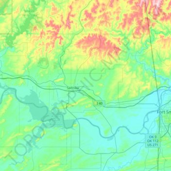
Name: Sequoyah County topographic map, elevation, terrain.
Location: Sequoyah County, Oklahoma, United States (35.29042 -95.13233 35.63872 -94.43121)
Average elevation: 692 ft
Minimum elevation: 394 ft
Maximum elevation: 1,919 ft
Oklahoma trails, hiking, mountain biking, running and outdoor activities
Other topographic maps
Click on a map to view its topography, its elevation and its terrain.
Sutton Urban Wilderness Park
United States > Oklahoma > Cleveland County > Norman
Average elevation: 1,198 ft
Medicine Bluffs
United States > Oklahoma > Comanche County > Lawton > White Wolf Bridge
Average elevation: 1,191 ft
Southwest Oklahoma City Sludge Lagoon Dam
United States > Oklahoma > Cleveland County > Oklahoma City
Average elevation: 1,142 ft
Newalla
United States > Oklahoma > Oklahoma County > Oklahoma City
Newalla, with a current elevation of 1,148 feet, is located within the Eastern bounds of Oklahoma County and appears on the Harrah, Oklahoma U.S. Geological Survey Map due to their proximity. Newalla is a geographic area which spans unincorporated Oklahoma County and unincorporated Cleveland County (also…
Average elevation: 1,125 ft
No Head Hollow Public Use Area
United States > Oklahoma > Cherokee County > Tahlequah
Average elevation: 876 ft
Honey Springs Battlefield
United States > Oklahoma > McIntosh County > Rentiesville
Average elevation: 607 ft
South East Corner Landing Strip
United States > Oklahoma > Comanche County
Average elevation: 1,257 ft
Lightning Creek Holding Pond B Dam
United States > Oklahoma > Oklahoma County > Oklahoma City
Average elevation: 1,266 ft