
建始县 topographic map
Interactive map
Click on the map to display elevation.
About this map
Name: 建始县 topographic map, elevation, terrain.
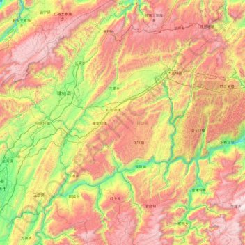
Location: 建始县, 恩施土家族苗族自治州, 湖北省, 中国 (30.11319 109.56311 30.90275 110.22194)
Average elevation: 3,704 ft
Minimum elevation: 650 ft
Maximum elevation: 7,280 ft
建始县位于鄂西南山区北部,东连巴东县,以野三河为界;西接恩施市,以太阳河为界;南邻鹤峰县,以长河、茶寮河为界;北与重庆市巫山县毗连;西北与重庆市奉节、巫山两县接壤。南北长89公里,东西最宽64.5公里,最窄处12.5公里,总面积2666.55平方公里。全县最高点北部太平峰海拔2090.1米,最低点东南部野三口(汇入清江处)海拔213米,平均海拔1152米。
Other topographic maps
Click on a map to view its topography, its elevation and its terrain.